
States of the Empire of the Great Lord, Also Known As Sultan and Emperor of the Ottoman Turks In Three Parts of the World: Europe, Asia, and Africa. (Estats De L'Empire Du Grand Seigneur Dit Sultan Et Ottomans Empereur Des Turcs Dans Trois Parties Du ...
- Regular price
-
$49.95 - Regular price
-
$34.95 - Sale price
-
$49.95
Buy one map, get any other map in our collection for 50% OFF! Add to cart to see discount.
Couldn't load pickup availability
About This Map
Discover the timeless beauty of our fine art quality printed reproduction of this antique map. Perfect for history enthusiasts, collectors, and interior decorators.
Restored with meticulous attention to detail by our team with over a decade of experience, this stunning reproduction captures the intricate artistry and historical significance of the original map.
Whether you're a collector or seeking a unique decor piece, this archival-quality map reproduction is a timeless addition to any space. Order now to bring history to life!
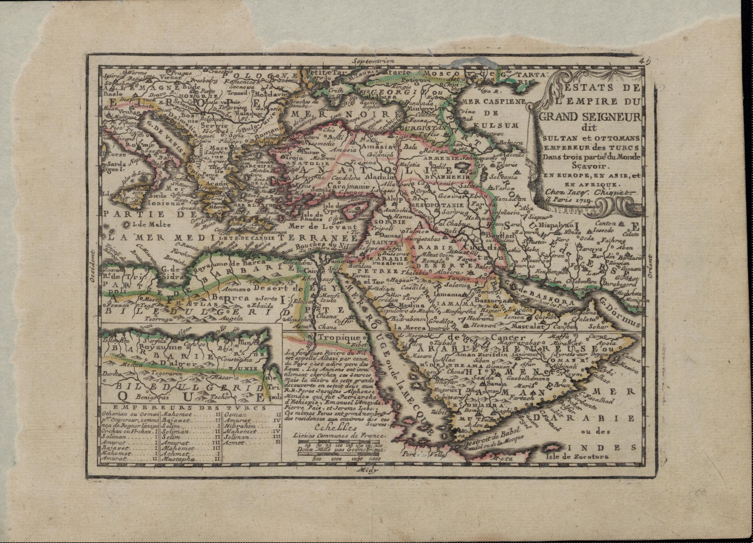
1721) was a French cartographer who published two atlases, both of which appeared in 1719: Le Nouveau et Curieux Atlas Geographique et Historique (New and curious geographic and historical atlas), a world atlas with 24 maps; and Noveau Atlas Francais (New French atlas), an atlas of France with 15 maps. Presented here is Chiquet's map of the Ottoman Empire, which spread over parts of the three continents of the old world: Africa, Asia, and Europe. In the lower left is a small inset map showing the extension of Ottoman territory along the coast of North Africa beyond the bounds of the main map. Also included is a table listing the Ottoman emperors, from Osman I (1258-1326) to Ahmed II (1643-95). A curious note on the bottom center of the map concerns the Nile and its sources. The note states that the ancients had been unable to discover the source of the river, but that this honor belonged to Pierre Pais (Pedro Páez), Alphonse Mendez (Alfonso Mendes), and other Jesuit priests active in Ethiopia in the early 17th century. The Jesuits had in fact identified the Blue Nile, one of the main sources of the river; the origins of the White Nile were not found by Europeans until the 19th century.Created by Jacques Chiquet in 1719.
- Title devised, in English, by Library staff.
- "Linear scale 29,600,000"--Note extracted from World Digital Library.
- Original resource extent: 1 map ; 29 x 21 centimeters.
- Original resource at: National and University Library "St Kliment Ohridski" -- Skopje.
- Content in French.
- Description based on data extracted from World Digital Library, which may be extracted from partner institutions.
- For the best legibility, order your map in the original size or larger. Most maps have intricate detail and small text that is best appreciated when the print size hasn't been reduced.
- Sizes labeled "Fits a Standard Frame" will drop right into any frame that you purchase in that size. The sizes that we offer are commonly available online and at most retail stores.
- Our standard sizes are recommendations based on the aspect ratio of the original map, but still may require some added "white space" in one dimension to fit.
- Non-standard sizes will require custom framing, and we suggest taking your print to the frame shop of your choice after you receive it for the best results.
- Custom sizes are available, simply contact us for a quote.
Below is an approximation of the scale of a few standard sizes, and how they might appear in your space.

