
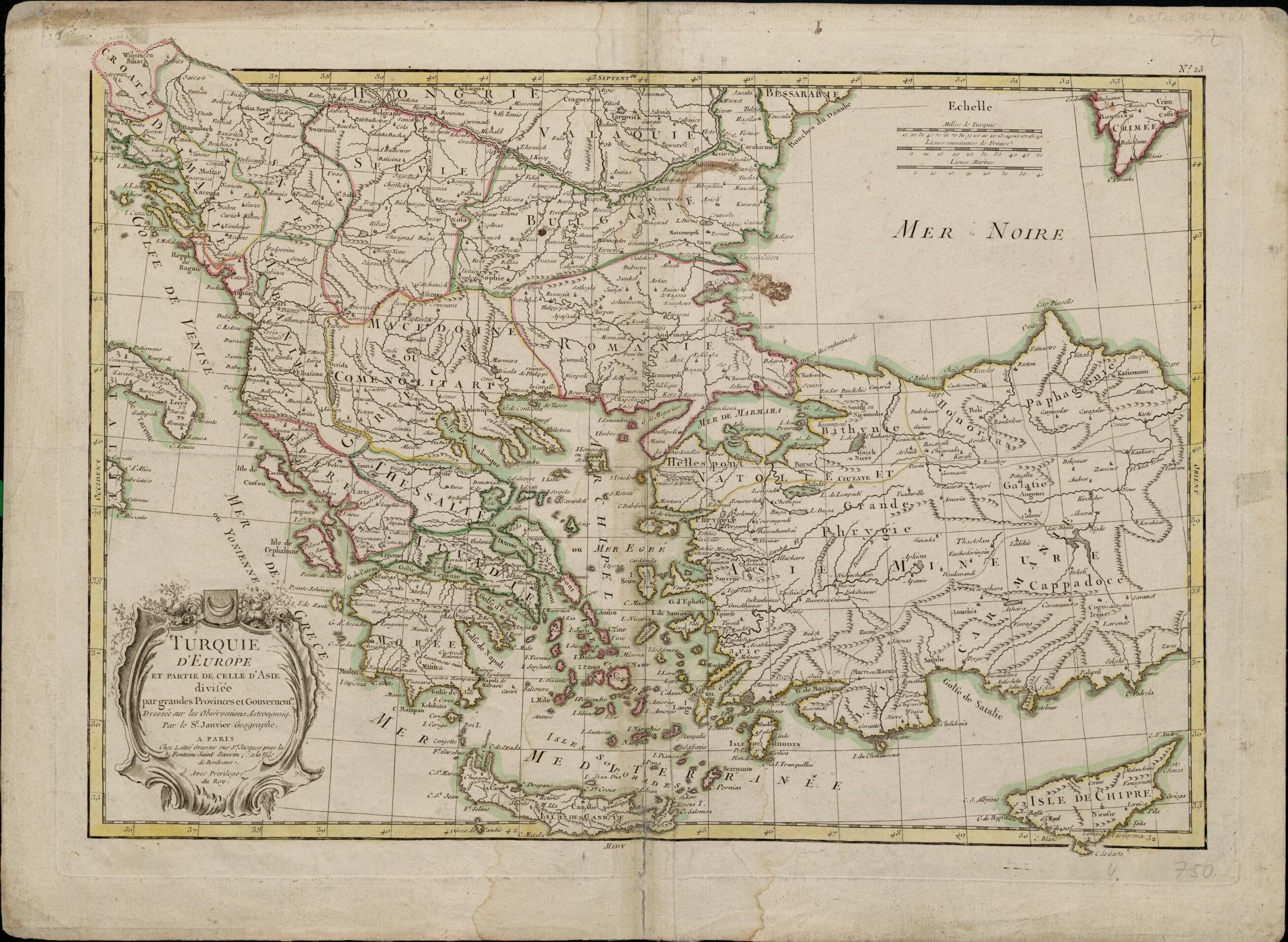
European Turkey and Part of Asian Turkey, Divided Into Large Provinces and Governorships. (Turquie D'Europe Et Partie De Celle D'Asie Divisée Par Grandes Provinces Et Gouvernemts) 1750
- Regular price
-
$54.95 - Regular price
-
$31.95 - Sale price
-
$54.95
Buy one map, get any other map in our collection for 50% OFF! Add to cart to see discount.
Couldn't load pickup availability
About This Map
Discover the timeless beauty of our fine art quality printed reproduction of this antique map. Perfect for history enthusiasts, collectors, and interior decorators.
Restored with meticulous attention to detail by our team with over a decade of experience, this stunning reproduction captures the intricate artistry and historical significance of the original map.
Whether you're a collector or seeking a unique decor piece, this archival-quality map reproduction is a timeless addition to any space. Order now to bring history to life!
Old map of Albania, Bosnia and Herzegovina, Bulgaria, Croatia, Cyprus, Former Yugoslav Republic of Macedonia, Greece, Hungary, Italy, Romania, Turkey.18th century French map shows the Balkan Peninsula, most of Anatolia (present-day Turkey), and the Mediterranean islands of Cyprus and Crete. The map bears the inscription "Sr. Janvier" ("Le Sieur Janvier"), a designation that refers to a cartographer active in Paris between 1746 and 1776 whose name was either Jean or Robert Janvier. The map offers a striking view of the European territories of the Ottoman Empire. Although past the peak of its power, the empire still controlled Albania, Bosnia, Bulgaria, Greece, Macedonia, Romania, and Serbia. The borders of these territories are demarcated by colored inks, and their names given in French. Countries bordering the Adriatic Sea (called the Gulf of Venice on the map) are shown, including parts of present-day Croatia that were then part of Venice, Dalmatia (also controlled by Venice at that time), and the Republic of Ragusa (present-day Dubrovnik, Croatia, and environs). Three distance scales are provided: Turkish miles, French leagues, and marine leagues.
Created by Jean Janvier in 1750.
- Title devised, in English, by Library staff.
- "Scale 1:3,700,000"--Note extracted from World Digital Library.
- Original resource extent: 1 map ; 50 x 37 centimeters.
- Original resource at: National and University Library "St Kliment Ohridski" -- Skopje.
- Content in French.
- Description based on data extracted from World Digital Library, which may be extracted from partner institutions.
- For the best legibility, order your map in the original size or larger. Most maps have intricate detail and small text that is best appreciated when the print size hasn't been reduced.
- Sizes labeled "Fits a Standard Frame" will drop right into any frame that you purchase in that size. The sizes that we offer are commonly available online and at most retail stores.
- Our standard sizes are recommendations based on the aspect ratio of the original map, but still may require some added "white space" in one dimension to fit.
- Non-standard sizes will require custom framing, and we suggest taking your print to the frame shop of your choice after you receive it for the best results.
- Custom sizes are available, simply contact us for a quote.
Below is an approximation of the scale of a few standard sizes, and how they might appear in your space.

