
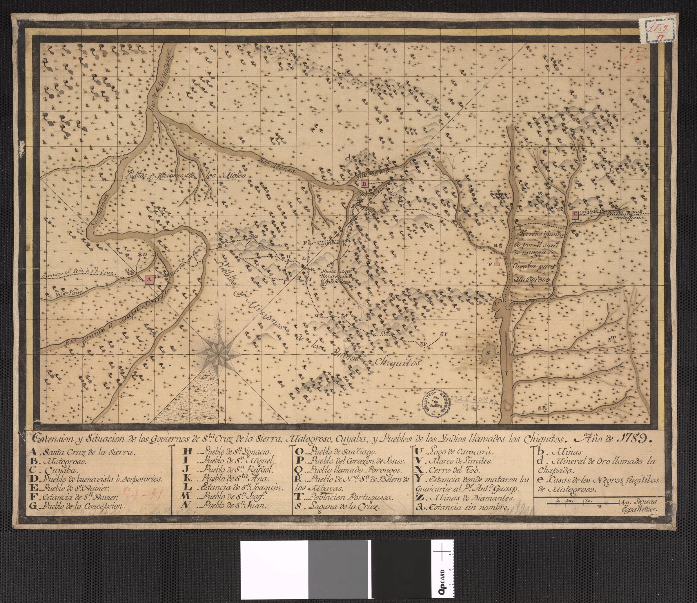
Extent and Location of the Governments of Santa Cruz De La Sierra, Matogroso, Cuyaba, and Towns of Native Americans Called Chiquitos. (Extension Y Situacion De Los Goviernos De Sta. Cruz De La Sierra, Matogroso, Cuyaba, Y Pueblos De Los Indios Llamado...
- Regular price
-
$49.95 - Regular price
-
$34.95 - Sale price
-
$49.95
Buy one map, get any other map in our collection for 50% OFF! Add to cart to see discount.
Couldn't load pickup availability
About This Map
Discover the timeless beauty of our fine art quality printed reproduction of this antique map. Perfect for history enthusiasts, collectors, and interior decorators.
Restored with meticulous attention to detail by our team with over a decade of experience, this stunning reproduction captures the intricate artistry and historical significance of the original map.
Whether you're a collector or seeking a unique decor piece, this archival-quality map reproduction is a timeless addition to any space. Order now to bring history to life!
Old map of Bolivia, Brazil.day Bolivian provinces of Santa Cruz de la Sierra and Chiquitos, and the Brazilian state of Mato Grosso. The map indicates the settlements of native people, known at that time as Chiquitos. This area was a center of Jesuit activity and many of the settlements may have been the remnants of Jesuit centers, called reducciones (reductions or townships). The Jesuits began their missionary work in South America in 1609. At the height of their activity, they sponsored 40 communities that were home to more than 150,000 native people. The major cities mentioned on the map, Santa Cruz de la Sierra and Cuyaba, were religious centers. Santa Cruz was an important staging point for the Jesuit missions, and Cuyaba, the capital of Mato Grosso, was established as a Catholic primature in 1745. The Jesuits were expelled from the Spanish colonies in 1767.
- Title devised, in English, by Library staff.
- Original resource extent: 1 manuscript map : color ; 35 x 45 centimeters.
- Original resource at: National Library of Brazil.
- Content in Spanish.
- Description based on data extracted from World Digital Library, which may be extracted from partner institutions.
- For the best legibility, order your map in the original size or larger. Most maps have intricate detail and small text that is best appreciated when the print size hasn't been reduced.
- Sizes labeled "Fits a Standard Frame" will drop right into any frame that you purchase in that size. The sizes that we offer are commonly available online and at most retail stores.
- Our standard sizes are recommendations based on the aspect ratio of the original map, but still may require some added "white space" in one dimension to fit.
- Non-standard sizes will require custom framing, and we suggest taking your print to the frame shop of your choice after you receive it for the best results.
- Custom sizes are available, simply contact us for a quote.
Below is an approximation of the scale of a few standard sizes, and how they might appear in your space.

