
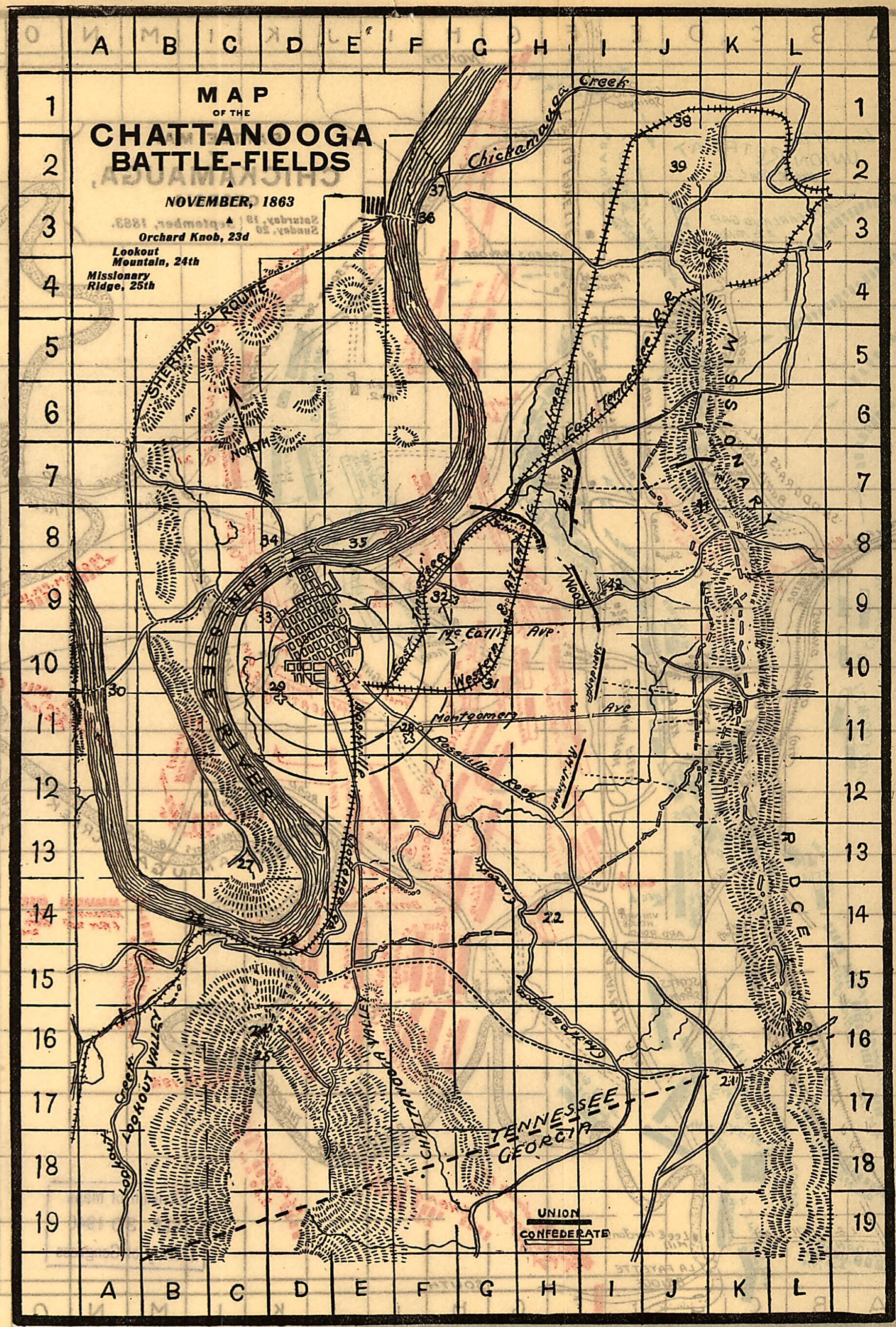
Fields, November, 1863. Orchard Knob, 23d, Lookout Mountain, 24th, Missionary Ridge, 25th 1898
- Regular price
-
$49.95 - Regular price
-
$29.95 - Sale price
-
$49.95
Buy one map, get any other map in our collection for 50% OFF! Add to cart to see discount.
Couldn't load pickup availability
About This Map
Discover the timeless beauty of our fine art quality printed reproduction of this antique map. Perfect for history enthusiasts, collectors, and interior decorators.
Restored with meticulous attention to detail by our team with over a decade of experience, this stunning reproduction captures the intricate artistry and historical significance of the original map.
Whether you're a collector or seeking a unique decor piece, this archival-quality map reproduction is a timeless addition to any space. Order now to bring history to life!
Old map of Chattanooga, Chickamauga, Georgia, Tennessee, United States.Created by Charles W. Norwood in 1898.
- Scale ca. 1:32,600. -- Scale ca. 1:63,360.
- Civil War Map
- In his The Chickamauga and Chattanooga battle-fields. Chatanooga, Gervis M. Connelly [1898] opp. p. 18-19.
- Cover title of pamphlet: Book of Battles Chickamauga, Chattanooga, Lookout Mountain, and Missionary Ridge.
- The Chickamauga map is divided "into quarter-mile sections, numbered 1 to 20 on the west and east margins, and lettered A to O on the north and sourth." Map indicates approximate troop positions, movements, commanding officers, a few houses and names of residents, roads, "Chatta., Rome & Southern R.R.," and drainage.
- The Chattanooga map is divided "into half-mile sections, numbered 1 to 19 on the west and east sides, and lettered A to L on the north and south." The map includes positions of "troops only in their critical situations," relief by hachures, drainage, railroads, and the outline of the streets of Chattanooga.
- On pages 3 to 31 in the pamphlet, there is a description of the battles with the points under discussion keyed by letter and number to the map.
- Description derived from published bibliography.
Map Subjects
Chattanooga
Chattanooga (Tenn.) Battle Of
Chattanooga Battle Of Chattanooga Tenn
Chickamauga
Chickamauga (Ga.) Battle Of
Chickamauga Battle Of GA
Georgia
Tennessee
United States
Charles W. Norwood
1898
- For the best legibility, order your map in the original size or larger. Most maps have intricate detail and small text that is best appreciated when the print size hasn't been reduced.
- Sizes labeled "Fits a Standard Frame" will drop right into any frame that you purchase in that size. The sizes that we offer are commonly available online and at most retail stores.
- Our standard sizes are recommendations based on the aspect ratio of the original map, but still may require some added "white space" in one dimension to fit.
- Non-standard sizes will require custom framing, and we suggest taking your print to the frame shop of your choice after you receive it for the best results.
- Custom sizes are available, simply contact us for a quote.
Below is an approximation of the scale of a few standard sizes, and how they might appear in your space.

