

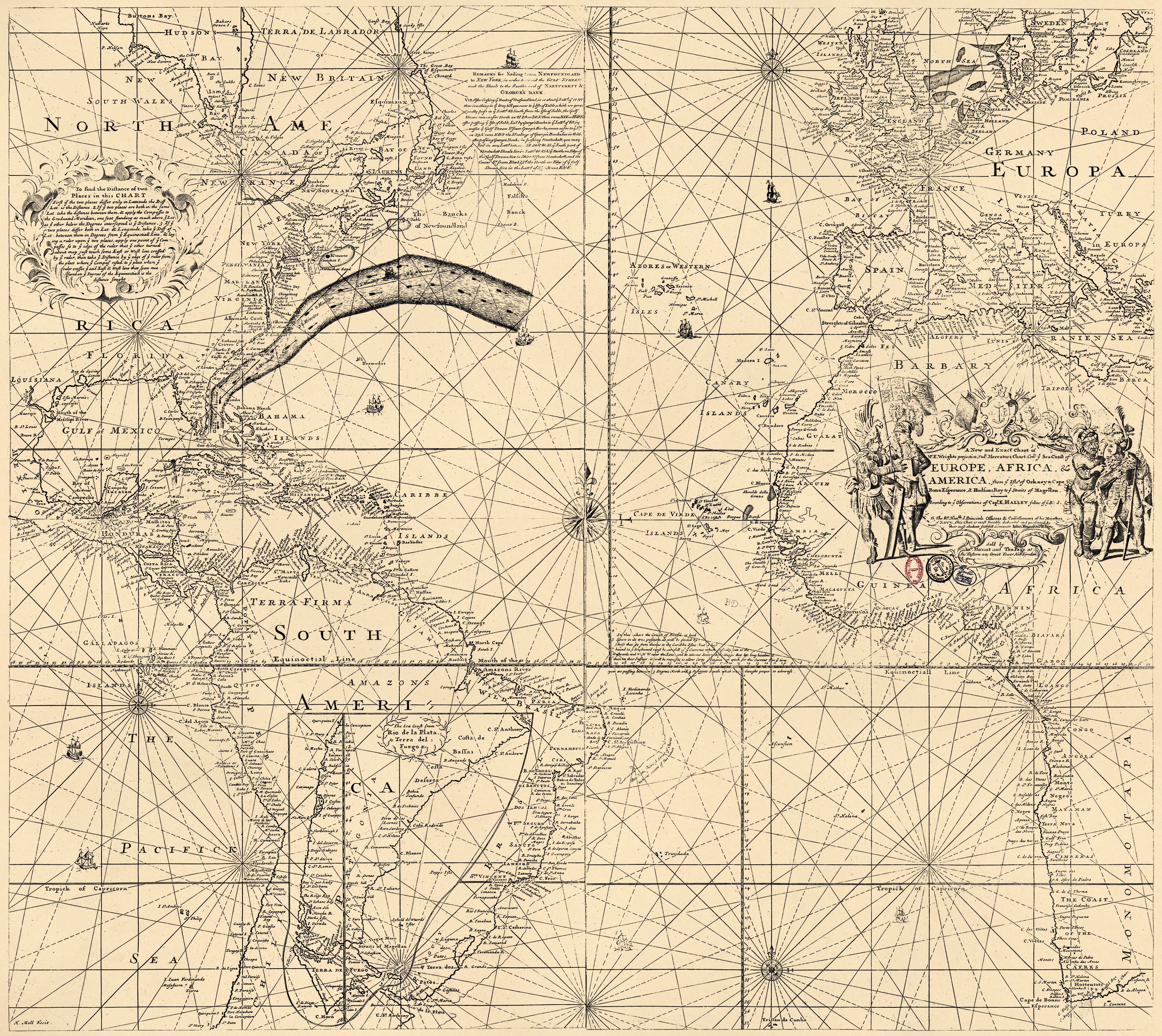
Folger Chart of the Gulf Stream in 1768
- Regular price
-
$96.95 - Regular price
-
$91.95 - Sale price
-
$96.95
Buy one map, get any other map in our collection for 50% OFF! Add to cart to see discount.
Couldn't load pickup availability
About This Map
Discover the timeless beauty of our fine art quality printed reproduction of this antique map. Perfect for history enthusiasts, collectors, and interior decorators.
Restored with meticulous attention to detail by our team with over a decade of experience, this stunning reproduction captures the intricate artistry and historical significance of the original map.
Whether you're a collector or seeking a unique decor piece, this archival-quality map reproduction is a timeless addition to any space. Order now to bring history to life!
Old map of Atlantic Ocean, Earth, Gulf Stream.Created by Timothy Folger, Benjamin Franklin, Edmond Halley, Jno. Mount and Tho. Page, Herman Moll, Edward Wright in 1768.
- Shows the Gulf Stream.
- Publication authorized by Benjamin Franklin and Timothy Folger.
- Gulf Stream information overprinted on: A new and exact chart of Mr. E. Wrights projection, rut. Mercators chart, con. ye sea coast of Europe, Africa & America, from ye Isles of Orkney to Cape Bona Esperance & Hudsons Bay to ye straits of Magellan, according to ye observations of Capt. E. Halley, fellow of ye R.S. / to the Rt. Honble., ye Principle Officers & Commissioners of His Majesties Navy ; this chart is most humbly dedicated and presented by their most obedient faithfull servants John Mount & Th. Page ; H. Moll fecit.
- Includes text and inset of "The sea coast from Rio de la Plata to Terra del Fuego &c."
- Acquisitions control no.: 14-88.
- For the best legibility, order your map in the original size or larger. Most maps have intricate detail and small text that is best appreciated when the print size hasn't been reduced.
- Sizes labeled "Fits a Standard Frame" will drop right into any frame that you purchase in that size. The sizes that we offer are commonly available online and at most retail stores.
- Our standard sizes are recommendations based on the aspect ratio of the original map, but still may require some added "white space" in one dimension to fit.
- Non-standard sizes will require custom framing, and we suggest taking your print to the frame shop of your choice after you receive it for the best results.
- Custom sizes are available, simply contact us for a quote.
Below is an approximation of the scale of a few standard sizes, and how they might appear in your space.

