
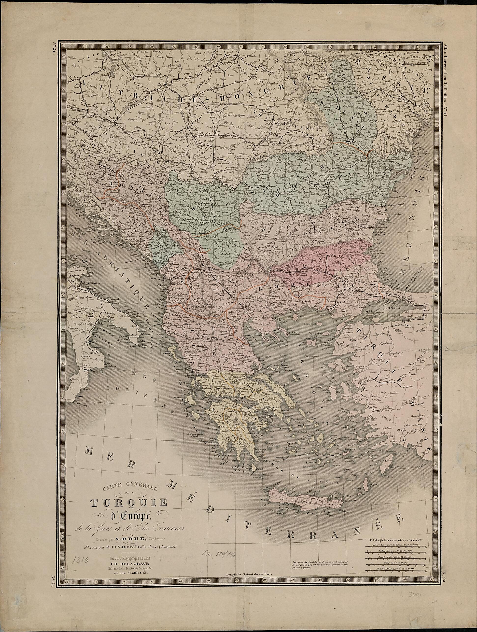
General Map of European Turkey, Greece and the Ionian Islands. (Carte Générale De La Turquie D'Europe, De La Grèce Et Des Iles Ioniennes) 1816
- Regular price
-
$51.95 - Regular price
-
$46.95 - Sale price
-
$51.95
Buy one map, get any other map in our collection for 50% OFF! Add to cart to see discount.
Couldn't load pickup availability
About This Map
Discover the timeless beauty of our fine art quality printed reproduction of this antique map. Perfect for history enthusiasts, collectors, and interior decorators.
Restored with meticulous attention to detail by our team with over a decade of experience, this stunning reproduction captures the intricate artistry and historical significance of the original map.
Whether you're a collector or seeking a unique decor piece, this archival-quality map reproduction is a timeless addition to any space. Order now to bring history to life!
Old map of Albania, Bosnia and Herzegovina, Bulgaria, Croatia, Former Yugoslav Republic of Macedonia, Greece, Hungary, Italy, Moldova, Montenegro, Romania, Serbia, Slovakia, Turkey, Ukraine.Hubert Brué (1786-1832) was a French geographer and cartographer who as a young man accompanied the explorer Nicolas Baudin on his 1800-1803 voyage to New Holland (Australia). Brué returned to France to become an important geographer, associated with the Institut Geographique de Paris and geographer to the king. His Grand atlas universel (Large universal atlas) was first published in 1816 and issued in revised and updated editions in 1825, 1830, and 1838. Shown here is Brué's map of the Ottoman Empire in Europe, Greece, and the Ionian Islands. The Ottoman territories in Europe were divided into 36 sanjaks, or administrative districts, of which six were in Greece. These districts are marked with colored ink, and their capitals indicated by underlining. Major roads are marked with black. Five distance scales are provided: common leagues, marine leagues, Turkish agashes, miles, and German miles. Greece declared its independence from the Ottoman Empire in 1821, and the Greek war of independence continued until 1832. Many people in France, Britain, and Russia were highly sympathetic to the Greeks and closely followed events in the country.
Created by Adrien Hubert Brué in 1816.
- Title devised, in English, by Library staff.
- "Scale 1:3,600,000"--Note extracted from World Digital Library.
- Original resource extent: 1 map ; 46 x 60 centimeters.
- Original resource at: National and University Library "St Kliment Ohridski" -- Skopje.
- Content in French.
- Description based on data extracted from World Digital Library, which may be extracted from partner institutions.
Map Subjects
Albania
Balkan Peninsula
Bosnia And Herzegovina
Bulgaria
Croatia
Former Yugoslav Republic Of Macedonia
Greece
Hungary
Italy
Moldova
Montenegro
Ottoman Empire
Romania
Serbia
Slovakia
Turkey
Ukraine
Adrien Hubert Brué
1816
- For the best legibility, order your map in the original size or larger. Most maps have intricate detail and small text that is best appreciated when the print size hasn't been reduced.
- Sizes labeled "Fits a Standard Frame" will drop right into any frame that you purchase in that size. The sizes that we offer are commonly available online and at most retail stores.
- Our standard sizes are recommendations based on the aspect ratio of the original map, but still may require some added "white space" in one dimension to fit.
- Non-standard sizes will require custom framing, and we suggest taking your print to the frame shop of your choice after you receive it for the best results.
- Custom sizes are available, simply contact us for a quote.
Below is an approximation of the scale of a few standard sizes, and how they might appear in your space.

