
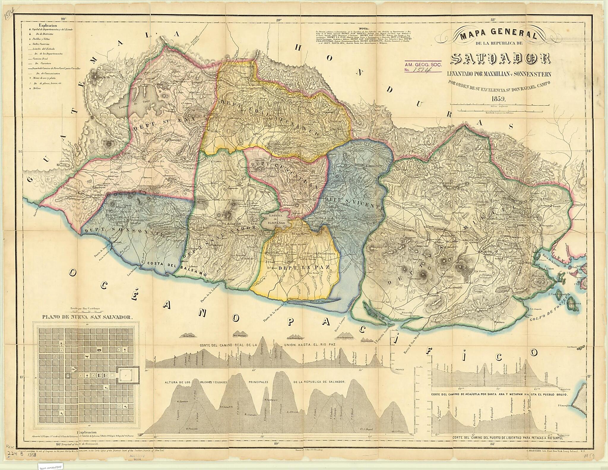
General Map of the Republic of El Salvador, 1858. (Mapa General De La Republica De Salvador)
- Regular price
-
$78.95 - Regular price
-
$73.95 - Sale price
-
$78.95
Buy one map, get any other map in our collection for 50% OFF! Add to cart to see discount.
Couldn't load pickup availability
About This Map
Discover the timeless beauty of our fine art quality printed reproduction of this antique map. Perfect for history enthusiasts, collectors, and interior decorators.
Restored with meticulous attention to detail by our team with over a decade of experience, this stunning reproduction captures the intricate artistry and historical significance of the original map.
Whether you're a collector or seeking a unique decor piece, this archival-quality map reproduction is a timeless addition to any space. Order now to bring history to life!
Old map of El Salvador.90), president of El Salvador in 1856-58. The map contains nine cross sections, showing the heights of mountains and volcanoes. An inset map depicts Nueva San Salvador, generally known today as Santa Tecla, which was founded in 1854 and briefly served as the national capital when San Salvador (located 11 kilometers to the northeast) was devastated by an earthquake. The map shows international borders with Guatemala and Honduras, department borders, cities and towns, rivers, roads, planned railroad lines, mines, mills, and the Pacific Ocean. Relief is shown by hachures. Two distance scales are given: Castilian leagues and English miles (one Castilian league = 4.18 kilometers; one mile = 1.61 kilometers).
Created by Rafael Campo, G. Kraetzer, J. Rau, Maximilian Von Sonnenstern in 1858.
- Title devised, in English, by Library staff.
- "Scale 1:370,000"--Note extracted from World Digital Library.
- Original resource extent: 1 map : color ; 54 x 74 centimeters.
- Original resource at: University of Wisconsin-Milwaukee Libraries.
- Content in Spanish.
- Description based on data extracted from World Digital Library, which may be extracted from partner institutions.
Map Subjects
El Salvador
Topographic Maps
Rafael Campo
G. Kraetzer
J. Rau
Maximilian Von Sonnenstern
1858
- For the best legibility, order your map in the original size or larger. Most maps have intricate detail and small text that is best appreciated when the print size hasn't been reduced.
- Sizes labeled "Fits a Standard Frame" will drop right into any frame that you purchase in that size. The sizes that we offer are commonly available online and at most retail stores.
- Our standard sizes are recommendations based on the aspect ratio of the original map, but still may require some added "white space" in one dimension to fit.
- Non-standard sizes will require custom framing, and we suggest taking your print to the frame shop of your choice after you receive it for the best results.
- Custom sizes are available, simply contact us for a quote.
Below is an approximation of the scale of a few standard sizes, and how they might appear in your space.

