
General Map of the Swedish Kingdom. (Generalkarta över Svenska Riket) 1688
- Regular price
-
$69.95 - Regular price
-
$64.95 - Sale price
-
$69.95
Buy one map, get any other map in our collection for 50% OFF! Add to cart to see discount.
Couldn't load pickup availability
About This Map
Discover the timeless beauty of our fine art quality printed reproduction of this antique map. Perfect for history enthusiasts, collectors, and interior decorators.
Restored with meticulous attention to detail by our team with over a decade of experience, this stunning reproduction captures the intricate artistry and historical significance of the original map.
Whether you're a collector or seeking a unique decor piece, this archival-quality map reproduction is a timeless addition to any space. Order now to bring history to life!
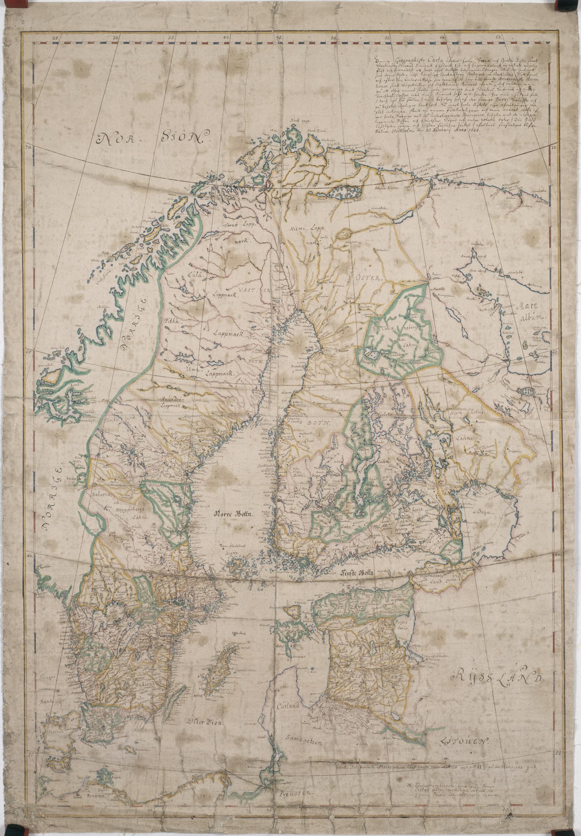
Old map of Finland, Sweden.-94) was appointed the first director of the Swedish Land Survey. Much of Sweden was at that time sparsely populated and not well surveyed. Gripenhielm undertook an ambitious program of mapping and surveying, extending over several decades. The completion of detailed maps of Sweden's agricultural land, forests, and surrounding seas coincided with the country's economic development and its rise to great power status under the rule of strong monarchs and a centralized state bureaucracy. By the 18th century, Sweden's cartographical and cadastral surveys had gained worldwide acclaim. This manuscript map by Gripenhielm depicts Sweden at the end of the 17th century. Sweden was at that time an empire whose rule extended over, in addition to Sweden itself, Finland, the Swedish Baltic provinces, and Swedish Pomerania. The note in the upper right, presumably by Gripenhielm or an assistant, reads: "This Geographic Map of all of Svea and Göta Kingdom, as well as the Grand Duchy of Finland, Livland, Est[land] and Ingermanland, has been compiled, with all possible diligence and through a whole year's work, from the regional maps that are available at this time in the Royal Surveying Office at the Palace of Stockholm, and according to the information obtained from Astronomical observations as well as Road maps and Sailings. Although in some places the maps of whole Provinces and Districts, Parishes and other areas have not yet been available, in such cases (still, in few places) earlier Swedish maps now out of print have had to be used. As soon as new measurements of the whole Kingdom are gathered, another, more complete and accurate map of all of Sweden will be made without fail, with the subordinate Provinces, and also the neighboring Kingdoms and borders, Lakes and other notable places (where God may safeguard [our] life time and bestow health). Date Stockholm February 10 Year 1688."
Created by Carl Gripenhielm in 1688.
- Title devised, in English, by Library staff.
- "Scale around 1 inch to 3,340,000 feet ; scale bar 10 Swedish miles equal 3.2 centimeters"--Note extracted from World Digital Library.
- Original resource extent: 1 handdrawn map : pencil, watercolor ; 74 x 51 centimeters.
- Original resource at: National Library of Sweden.
- Content in Swedish.
- Description based on data extracted from World Digital Library, which may be extracted from partner institutions.
- For the best legibility, order your map in the original size or larger. Most maps have intricate detail and small text that is best appreciated when the print size hasn't been reduced.
- Sizes labeled "Fits a Standard Frame" will drop right into any frame that you purchase in that size. The sizes that we offer are commonly available online and at most retail stores.
- Our standard sizes are recommendations based on the aspect ratio of the original map, but still may require some added "white space" in one dimension to fit.
- Non-standard sizes will require custom framing, and we suggest taking your print to the frame shop of your choice after you receive it for the best results.
- Custom sizes are available, simply contact us for a quote.
Below is an approximation of the scale of a few standard sizes, and how they might appear in your space.

