
Geographic Chart of the Kingdom of Chile. (Tabula Geographica Regni Chile) 1646
- Regular price
-
$49.95 - Regular price
-
$34.95 - Sale price
-
$49.95
Buy one map, get any other map in our collection for 50% OFF! Add to cart to see discount.
Couldn't load pickup availability
About This Map
Discover the timeless beauty of our fine art quality printed reproduction of this antique map. Perfect for history enthusiasts, collectors, and interior decorators.
Restored with meticulous attention to detail by our team with over a decade of experience, this stunning reproduction captures the intricate artistry and historical significance of the original map.
Whether you're a collector or seeking a unique decor piece, this archival-quality map reproduction is a timeless addition to any space. Order now to bring history to life!
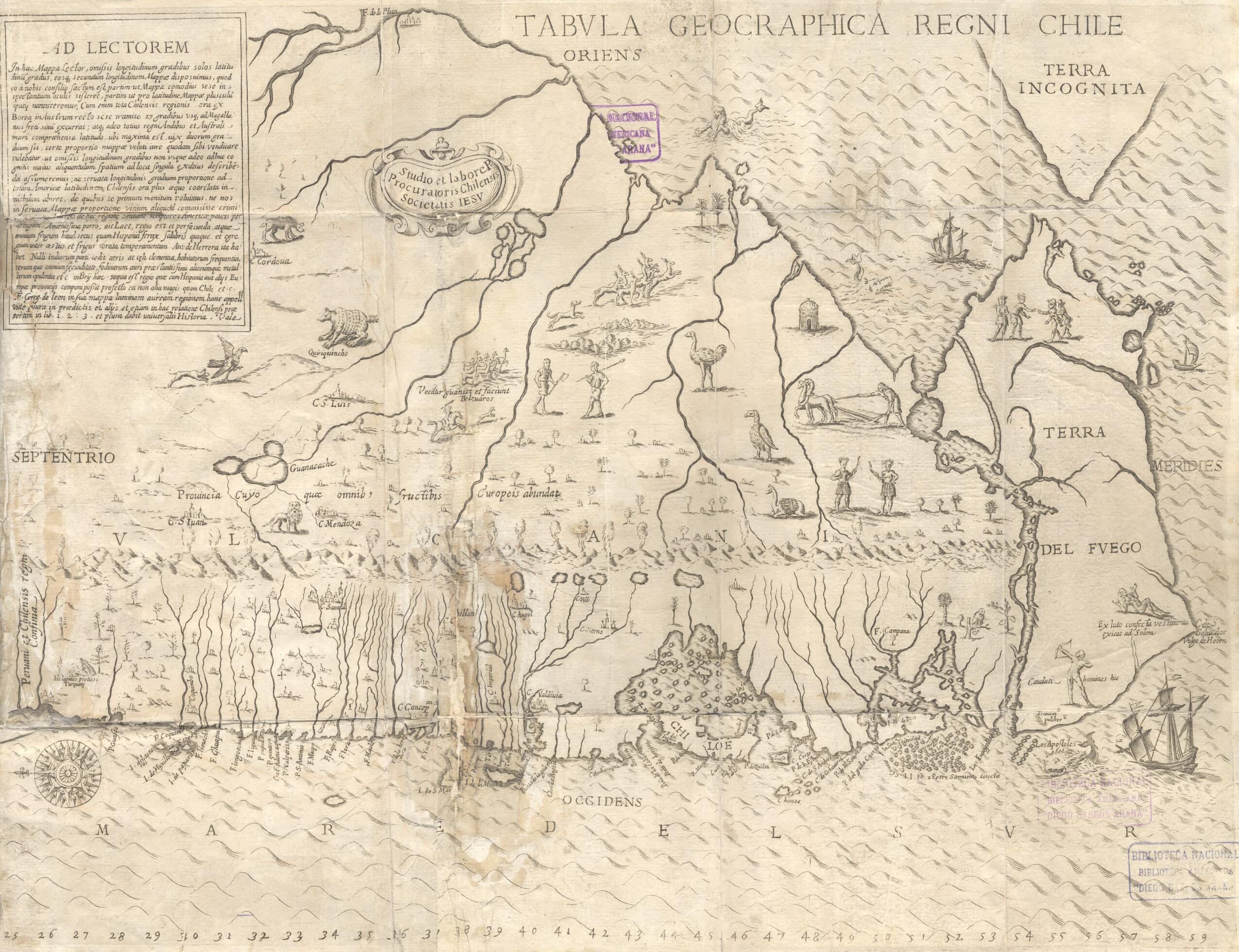
Old map of Chile.-51) appears in his book Histórica Relación del Reyno de Chile (Historical narration about the kingdom of Chile), considered the first history of the country. The map is the result of a major descriptive effort begun during Ovalle's first trip to Europe, as "Procurator" of Chile, in 1641. At the time, the Jesuits needed support for their missionary work in the south of Chile, and Ovalle was commissioned to recruit help and raise money. Answering the need for information about the country, Ovalle's book and map were published in Rome in 1646, in both Spanish and Italian editions. The printer was Francesco Cavallo; Ovalle dedicated the work to Pope Innocent X. The book highlighted Jesuit missionary activities and focused on the physical, social, and cultural aspects of Chile during the first 40 years of the 17th century. It provided detailed topographical and ethnological descriptions of the southern settlements. Ovalle's map complemented the text with illustrations of volcanoes, rivers, and lakes, along with decorative images of wildlife and vegetation and scenes of people engaged in various social and commercial activities. The figure of a native with a tail is a puzzling, unexplained detail. From a cartographic perspective, the map contains errors. In his statement to the reader (Ad Lectorem), Ovalle admits uncertainties and the absence of longitudes. The orientation of the map is unusual. North (septentrio) is on the left, placing Tierra del Fuego on the right. The Strait of Magellan divides the mainland from "Terra Incognita," the as-yet unknown Antarctica, which is placed in the upper right-hand corner, to the southeast of the South American continent.
Created by Alonso De Ovalle, Society of Jesus in 1646.
- Title devised, in English, by Library staff.
- Original resource extent: 1 map ; 23 x 13 centimeters.
- Original resource at: National Library of Chile.
- Content in Latin.
- Description based on data extracted from World Digital Library, which may be extracted from partner institutions.
- For the best legibility, order your map in the original size or larger. Most maps have intricate detail and small text that is best appreciated when the print size hasn't been reduced.
- Sizes labeled "Fits a Standard Frame" will drop right into any frame that you purchase in that size. The sizes that we offer are commonly available online and at most retail stores.
- Our standard sizes are recommendations based on the aspect ratio of the original map, but still may require some added "white space" in one dimension to fit.
- Non-standard sizes will require custom framing, and we suggest taking your print to the frame shop of your choice after you receive it for the best results.
- Custom sizes are available, simply contact us for a quote.
Below is an approximation of the scale of a few standard sizes, and how they might appear in your space.

