
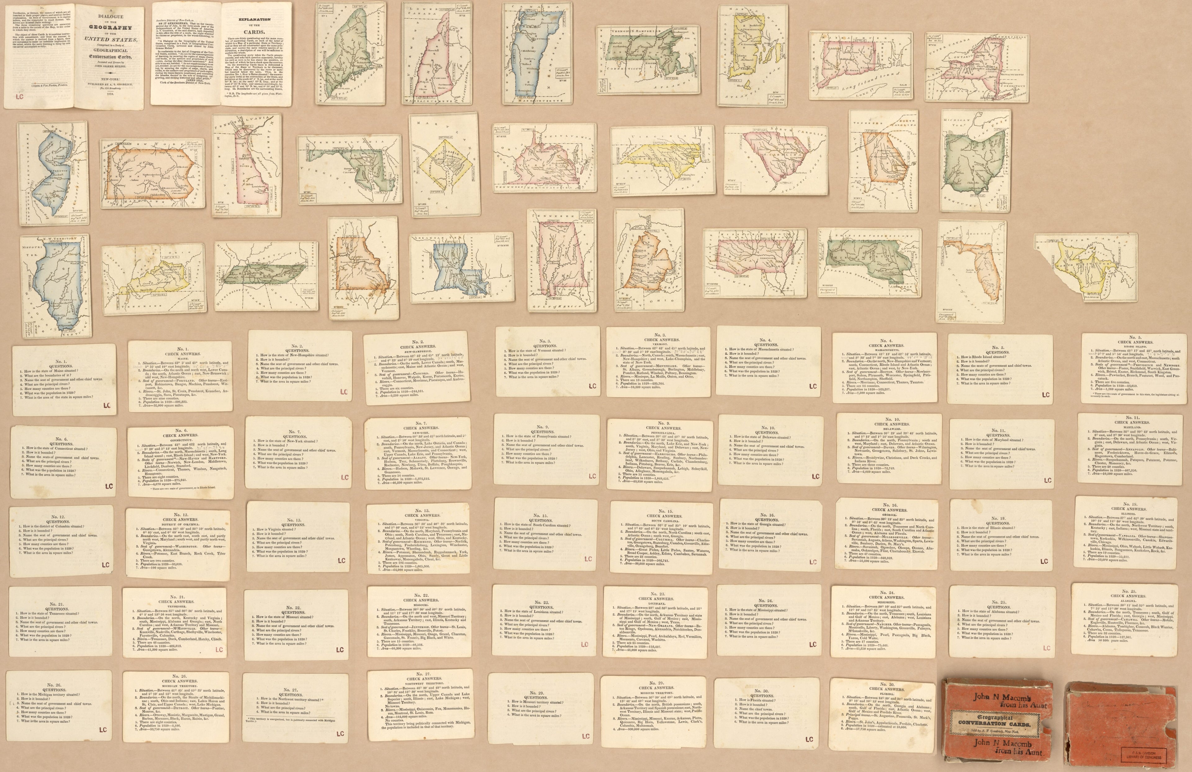
Geographical Conversation Cards : states of the United States in 1824
- Regular price
-
$193.95 - Regular price
-
$188.95 - Sale price
-
$193.95
Buy one map, get any other map in our collection for 50% OFF! Add to cart to see discount.
Couldn't load pickup availability
About This Map
Discover the timeless beauty of our fine art quality printed reproduction of this antique map. Perfect for history enthusiasts, collectors, and interior decorators.
Restored with meticulous attention to detail by our team with over a decade of experience, this stunning reproduction captures the intricate artistry and historical significance of the original map.
Whether you're a collector or seeking a unique decor piece, this archival-quality map reproduction is a timeless addition to any space. Order now to bring history to life!
Old map of United States.Created by Clayton & Van Norden, A. T. (Andrew Thompson) Goodrich, John Græme Melish in 1824.
- Each playing card has a map of 1 state or territory of the U.S.
- Title from printed label affixed to box.
- Pack complete in 30 playing cards.
- Incomplete: 28 playing cards and 24 question-and-answer cards as of May 2002.
- This map has some imperfections: north west territory card has sw quarter torn away, verso of some cards annotated in lead pencil, box torn and missing small sections, box rubber-stamped: john n. macomb from his aunt. We'll do our best to restore the image before printing.
- Each playing card is accompanied by a corresponding question-and-answer card.
- Pack accompanied by text: A dialogue on the geography of the United States : comprised in a pack of geographical conversation cards. iv p. ; 9 cm.
- Each playing card includes small rectangle containing statistical data.
- Acquisitions control no.: 98-18
- For the best legibility, order your map in the original size or larger. Most maps have intricate detail and small text that is best appreciated when the print size hasn't been reduced.
- Sizes labeled "Fits a Standard Frame" will drop right into any frame that you purchase in that size. The sizes that we offer are commonly available online and at most retail stores.
- Our standard sizes are recommendations based on the aspect ratio of the original map, but still may require some added "white space" in one dimension to fit.
- Non-standard sizes will require custom framing, and we suggest taking your print to the frame shop of your choice after you receive it for the best results.
- Custom sizes are available, simply contact us for a quote.
Below is an approximation of the scale of a few standard sizes, and how they might appear in your space.
