

Geographic Description of the Travels of the Apostles and the Journeys of Paul, Together With the Countries and Empires Where They First Preached the Gospel. (Geographische Beschryvinghe Van De Wandeling Der Apostelen Ende De Reysen Pauli, Mitsgaders ...
- Regular price
-
$55.95 - Regular price
-
$50.95 - Sale price
-
$55.95
Buy one map, get any other map in our collection for 50% OFF! Add to cart to see discount.
Couldn't load pickup availability
About This Map
Discover the timeless beauty of our fine art quality printed reproduction of this antique map. Perfect for history enthusiasts, collectors, and interior decorators.
Restored with meticulous attention to detail by our team with over a decade of experience, this stunning reproduction captures the intricate artistry and historical significance of the original map.
Whether you're a collector or seeking a unique decor piece, this archival-quality map reproduction is a timeless addition to any space. Order now to bring history to life!
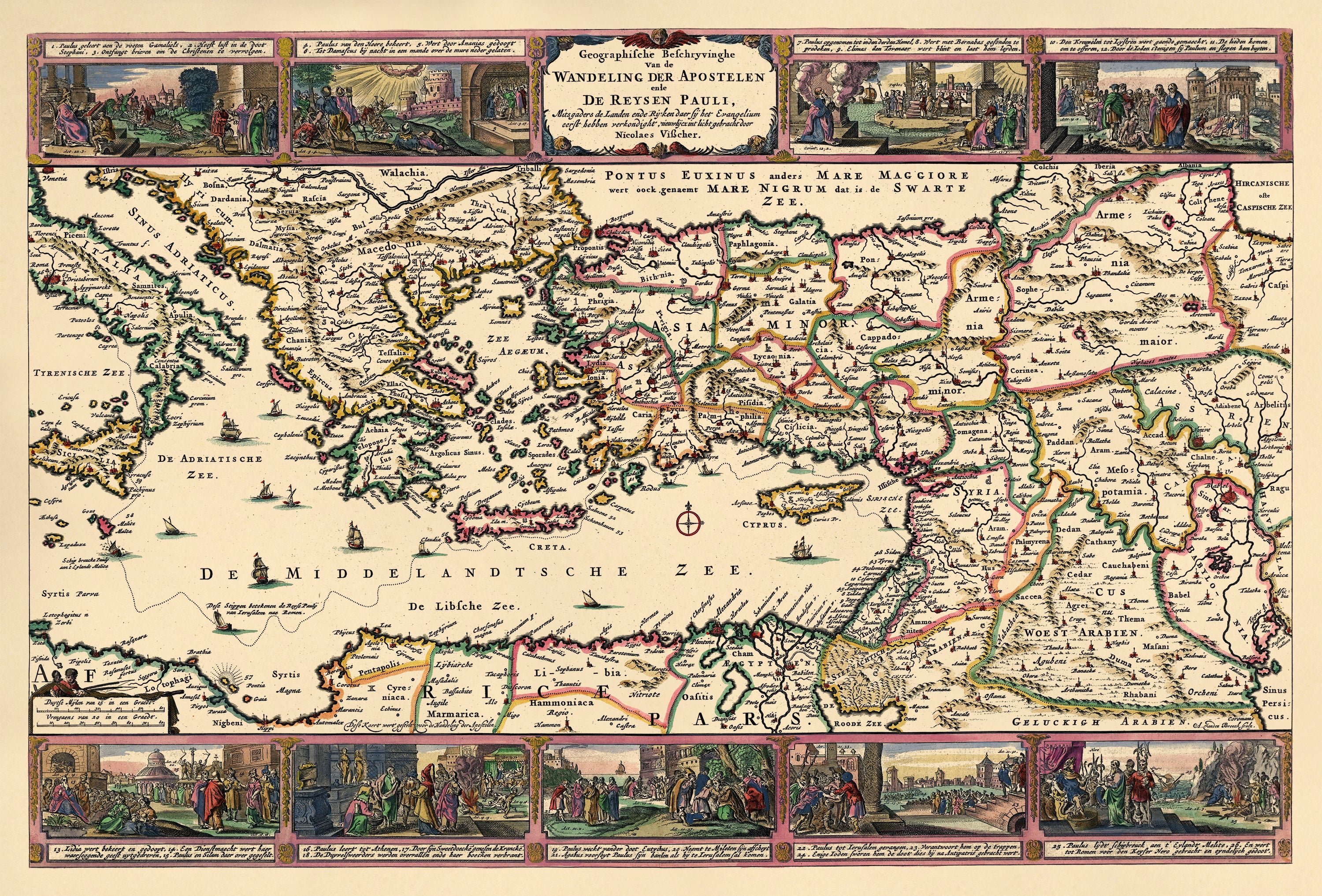
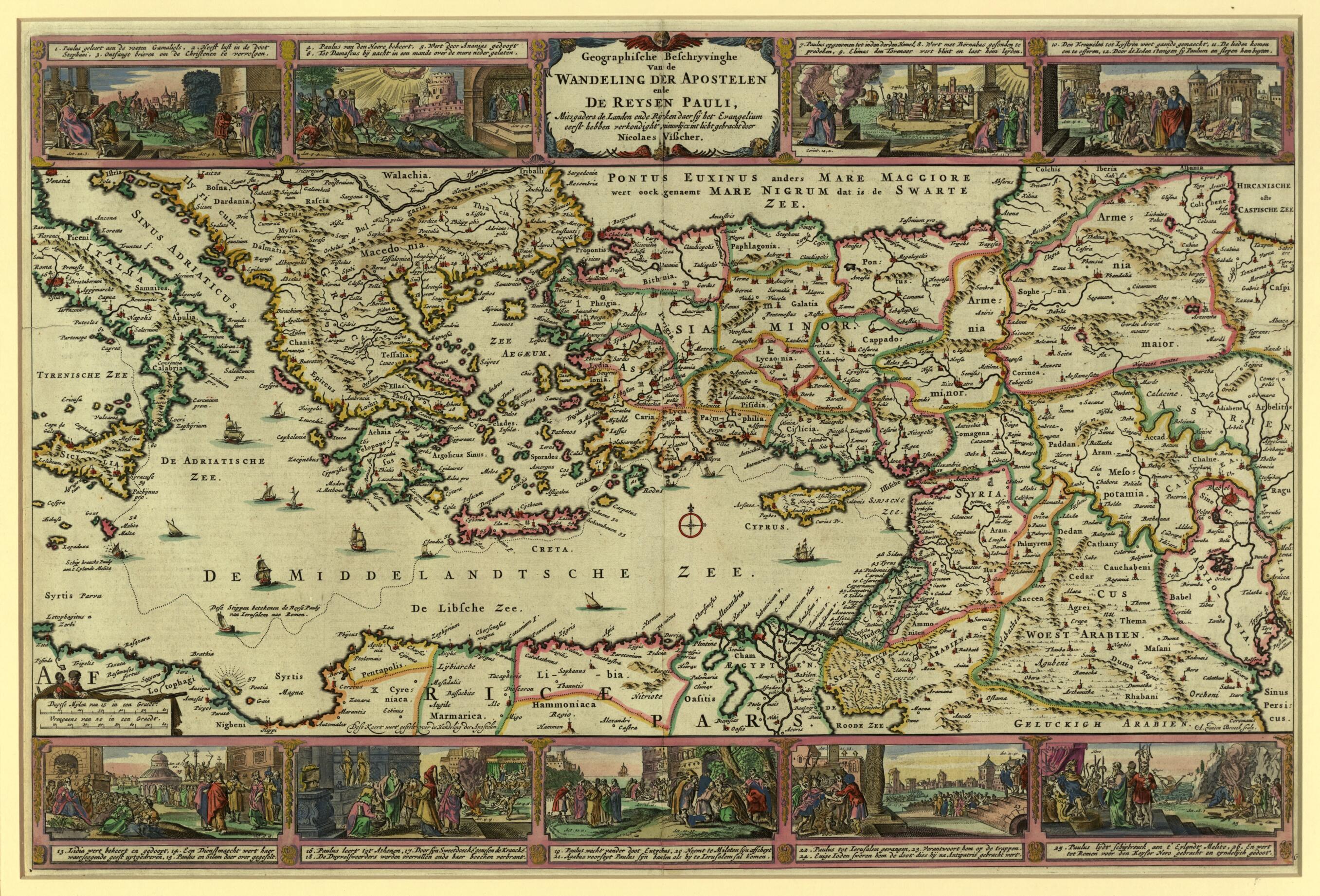
Old map of Cyprus, Egypt, Greece, Israel, Italy, Lebanon, Libya, Syrian Arab Republic, Turkey.79) shows the eastern Mediterranean and environs in the first century AD and the journey of the Apostle Paul from Jerusalem to Rome in 60--61. Nine panels surrounding the map depict major scenes from the life of Paul and the journey, including his being blinded on the road to Damascus, his baptism, his escape from Damascus, shipwreck off the island of Malta (also illustrated on the map), and his appearance before the Emperor Nero in Rome. Each panel is a composite containing two or three scenes from the apostle's life; annotations link the scenes to the appropriate Bible verses. The map was engraved and hand colored to display the administrative and political divisions of the period. Numerous cities, towns, islands, and regions are labeled, including Memphis, Alexandria, Jerusalem, Babel, Tripoli, Constantinople, Athens, and Rome. The seas are decorated with sailing ships and a compass rose. Members of the Visscher family were important art and map dealers in Amsterdam for about 100 years, beginning in the early 17th century. The Visschers worked primarily as art dealers, but they were also publishers who produced individual maps and compiled atlases to order. Their works are noteworthy for their fine engraving, the accuracy of the maps, and the beautiful illustrations.
Created by Nicolaes Visscher in 1642.
- Title devised, in English, by Library staff.
- Original resource extent: 1 map ; 22 x 48 centimeters.
- Original resource at: Qatar National Library.
- Content in German and Dutch.
- Description based on data extracted from World Digital Library, which may be extracted from partner institutions.
- For the best legibility, order your map in the original size or larger. Most maps have intricate detail and small text that is best appreciated when the print size hasn't been reduced.
- Sizes labeled "Fits a Standard Frame" will drop right into any frame that you purchase in that size. The sizes that we offer are commonly available online and at most retail stores.
- Our standard sizes are recommendations based on the aspect ratio of the original map, but still may require some added "white space" in one dimension to fit.
- Non-standard sizes will require custom framing, and we suggest taking your print to the frame shop of your choice after you receive it for the best results.
- Custom sizes are available, simply contact us for a quote.
Below is an approximation of the scale of a few standard sizes, and how they might appear in your space.
