
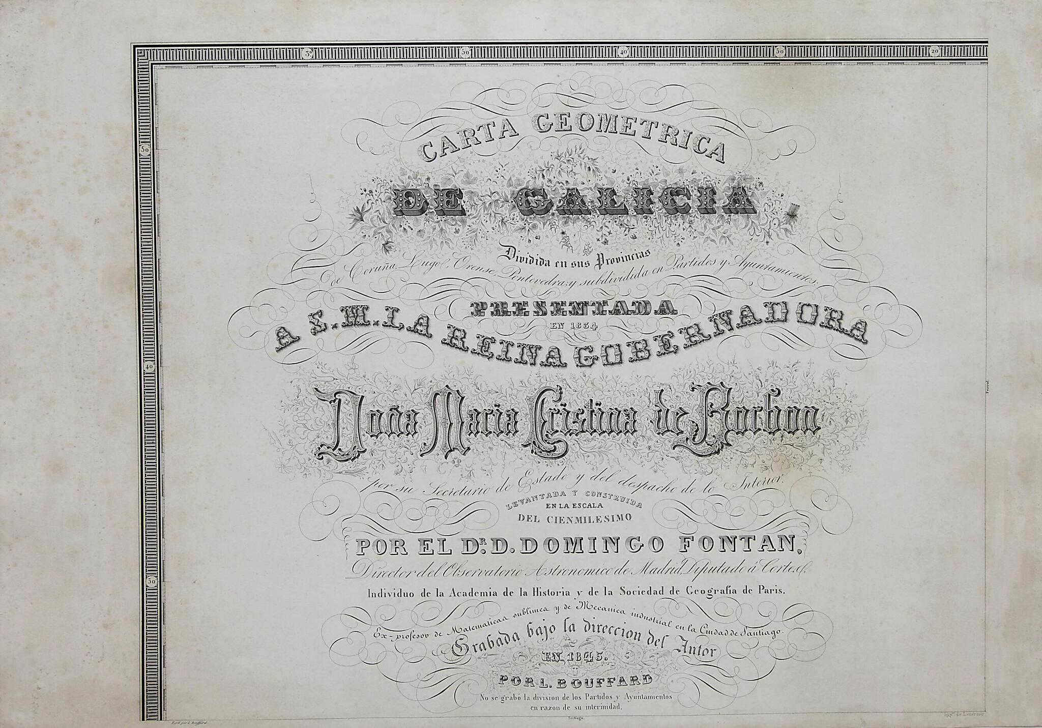
Geometric Chart of Galicia: Divided Into the Provinces of La Coruña, Lugo, Orense, and Pontevedra; and Subdivided by Judicial Districts and Town Councils. (Carta Geométrica De Galicia Dividida En Sus Provincias De Coruña, Lugo, Orense, Pontevedra Y...
- Regular price
-
$49.95 - Regular price
-
$29.95 - Sale price
-
$49.95
Buy one map, get any other map in our collection for 50% OFF! Add to cart to see discount.
Couldn't load pickup availability
About This Map
Discover the timeless beauty of our fine art quality printed reproduction of this antique map. Perfect for history enthusiasts, collectors, and interior decorators.
Restored with meticulous attention to detail by our team with over a decade of experience, this stunning reproduction captures the intricate artistry and historical significance of the original map.
Whether you're a collector or seeking a unique decor piece, this archival-quality map reproduction is a timeless addition to any space. Order now to bring history to life!
Old map of Galicia, Spain.1866), a leading figure of his day in Galicia, was a polymath--a mathematician, geographer, philosopher, and politician--who, with the work presented here, created the first scientific topographical map of Galicia. It was based on the method of geodesic triangulation, which Fontán had developed. He began work on the project in 1817 but did not receive official support for it until about 12 years later. It took Fontán until 1834 to complete his chart, which is inscribed "Presentada en 1834 a S.M. La Reina Gobernadora Doña Maria Cristina de Borbon" (Presented in 1834 to Her Majesty, the Queen Regent, Doña Maria Cristina de Borbon). The work was not printed until 1845, by which time Fontán had made some corrections and enhancements to the original manuscript. He moved to Paris to oversee the printing process, for which 12 lithographic plates were engraved on stone by L. Bouffard; the chart was printed by Joseph Lemercier. The scale of 1:100,000 is also expressed in leagues of 20,000 feet, and miles in degrees and in thousands of meters (kilometers). An explanatory key appears on the last page. The Carta geométrica de Galicia (Geometric chart of Galicia), despite its high quality, accuracy, and detail, did not receive the distribution it deserved and was not even considered an "official map." Its ultimate recognition was due mainly to the influence it had on geographers such as Francisco de Coello (1822-98), whose debt to Fontán he acknowledged in the maps of the Galician provinces in his Atlas de España y sus posesiones de ultramar (Atlas of Spain and its overseas possessions). It is through these later maps that Fontán's work became, albeit indirectly, known to the public.
Created by L. Bouffard, Domingo Fontán Rodríguez, Joseph Lemercier, Queen María Cristina in 1845.
- Title devised, in English, by Library staff.
- "Scale approximately 1:100,000"--Note extracted from World Digital Library.
- Original resource extent: 1 map in 12 sections : lithograph, black-and-white ; 63 x 90 centimeters.
- Original resource at: Library of Galicia.
- Content in Spanish.
- Description based on data extracted from World Digital Library, which may be extracted from partner institutions.
Map Subjects
Administrative And Political Divisions
Galicia
Spain
Topographic Maps
L. Bouffard
Domingo Fontán Rodríguez
Joseph Lemercier
Queen María Cristina
1845
- For the best legibility, order your map in the original size or larger. Most maps have intricate detail and small text that is best appreciated when the print size hasn't been reduced.
- Sizes labeled "Fits a Standard Frame" will drop right into any frame that you purchase in that size. The sizes that we offer are commonly available online and at most retail stores.
- Our standard sizes are recommendations based on the aspect ratio of the original map, but still may require some added "white space" in one dimension to fit.
- Non-standard sizes will require custom framing, and we suggest taking your print to the frame shop of your choice after you receive it for the best results.
- Custom sizes are available, simply contact us for a quote.
Below is an approximation of the scale of a few standard sizes, and how they might appear in your space.
