
Great Circle Sailing Chart of the North Atlantic Ocean 1926
- Regular price
-
$141.95 - Regular price
-
$136.95 - Sale price
-
$141.95
Buy one map, get any other map in our collection for 50% OFF! Add to cart to see discount.
Couldn't load pickup availability
About This Map
Discover the timeless beauty of our fine art quality printed reproduction of this antique map. Perfect for history enthusiasts, collectors, and interior decorators.
Restored with meticulous attention to detail by our team with over a decade of experience, this stunning reproduction captures the intricate artistry and historical significance of the original map.
Whether you're a collector or seeking a unique decor piece, this archival-quality map reproduction is a timeless addition to any space. Order now to bring history to life!
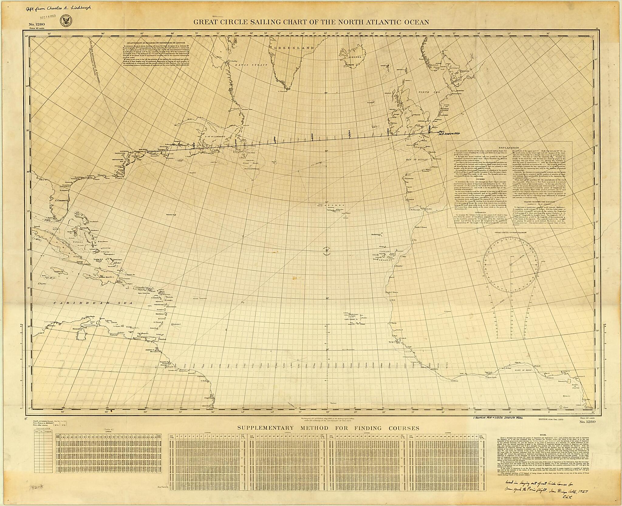
-74) was the American aviator who made the first nonstop solo flight across the Atlantic Ocean on May 21--22, 1927. This is the chart with the gnomonic projection that he referred to as the "nugget of gold" that he found in a shop in San Pedro, California, while preparing for his transatlantic flight. It was this chart that enabled Lindbergh to determine quickly and accurately the great circle latitudes and longitudes as he plotted his course. The annotation on the map reads, "Used in laying out Great Circle Course for New York to Paris flight. San Diego, Calif. 1927. C.A.L." In his 1953 book, The Spirit of St. Louis, Lindbergh described his use of this map: "My navigating problems have begun to clarify. I found, printed on the charts I bought, ample instructions for laying out my great-circle route. With the instruments Hall loaned me, I drew a straight line between New York and Paris on the gnomonic projection. Then I transferred points from that line, at hundred-mile intervals, to the Mercator's projection, and connected these points with straight lines. At each point, I mark down the distance from New York and the magnetic course to the next change in angle."Created by Charles A. (Charles Augustus) Lindbergh, United States. Hydrographic Office in 1926.
- Title devised, in English, by Library staff.
- "Scale 1:14,000,000. 41st edition."--Note extracted from World Digital Library.
- Original resource extent: 1 map : color, annotated ; 64 x 96 centimeters, on sheet 74 x 101 centimeters.
- Original resource at: University of Wisconsin-Milwaukee Libraries.
- Content in English.
- Description based on data extracted from World Digital Library, which may be extracted from partner institutions.
Map Subjects
Flight
Circle Sailing
Nautical Charts
North Atlantic Ocean
Transatlantic Flights
Charles A. (Charles Augustus) Lindbergh
United States. Hydrographic Office
1926
- For the best legibility, order your map in the original size or larger. Most maps have intricate detail and small text that is best appreciated when the print size hasn't been reduced.
- Sizes labeled "Fits a Standard Frame" will drop right into any frame that you purchase in that size. The sizes that we offer are commonly available online and at most retail stores.
- Our standard sizes are recommendations based on the aspect ratio of the original map, but still may require some added "white space" in one dimension to fit.
- Non-standard sizes will require custom framing, and we suggest taking your print to the frame shop of your choice after you receive it for the best results.
- Custom sizes are available, simply contact us for a quote.
Below is an approximation of the scale of a few standard sizes, and how they might appear in your space.

