
Guiana and Caribana. (Guiana, Verdeelt In Guiana En Caribana) 1700
- Regular price
-
$49.95 - Regular price
-
$34.95 - Sale price
-
$49.95
Buy one map, get any other map in our collection for 50% OFF! Add to cart to see discount.
Couldn't load pickup availability
About This Map
Discover the timeless beauty of our fine art quality printed reproduction of this antique map. Perfect for history enthusiasts, collectors, and interior decorators.
Restored with meticulous attention to detail by our team with over a decade of experience, this stunning reproduction captures the intricate artistry and historical significance of the original map.
Whether you're a collector or seeking a unique decor piece, this archival-quality map reproduction is a timeless addition to any space. Order now to bring history to life!
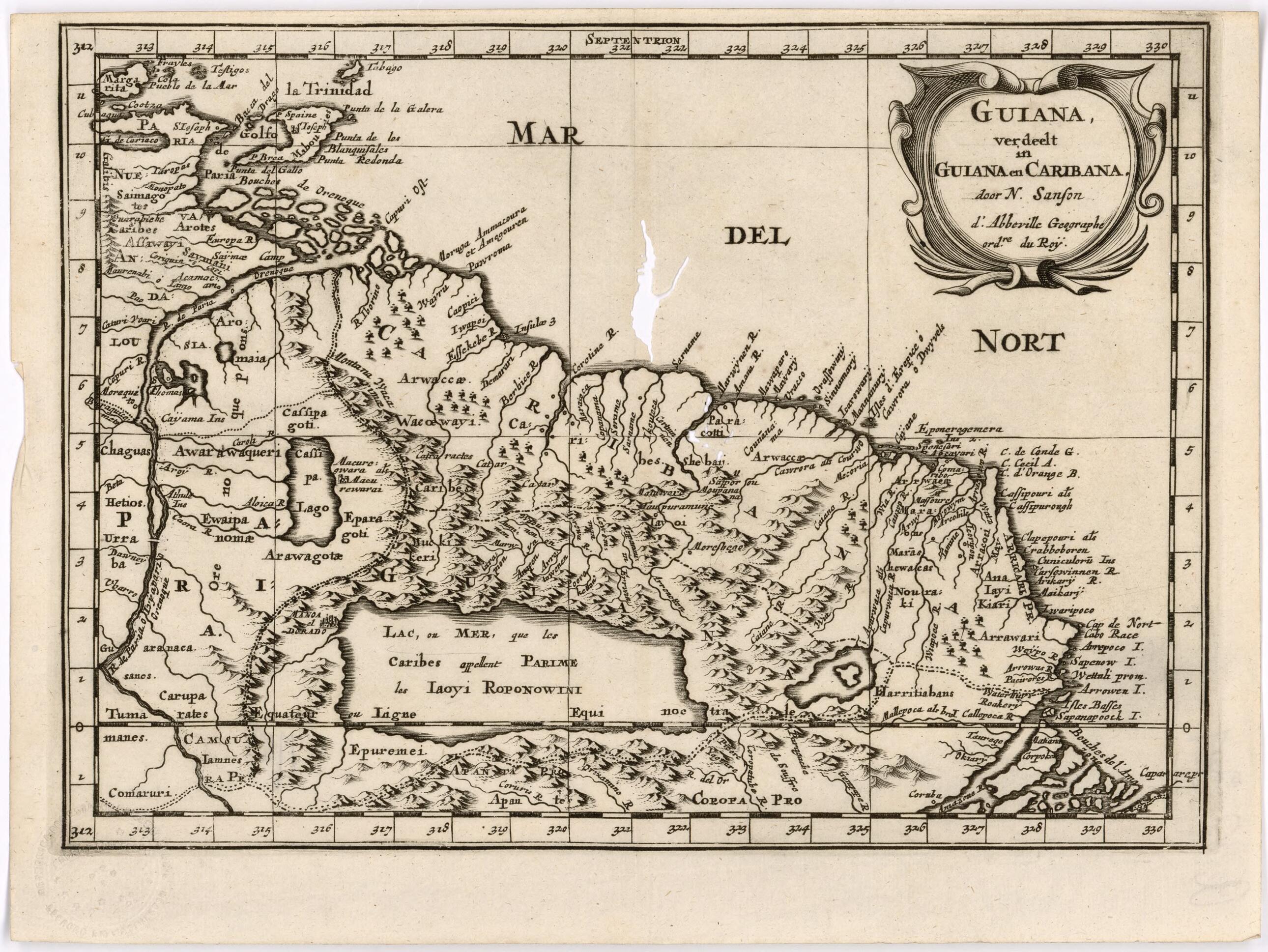
Old map of Brazil, France, French Guiana, Guyana, Suriname, Trinidad and Tobago, Venezuela (Bolivarian Republic of).-1667), royal geographer to Kings Louis XIII and XIV, and commonly known as the father of French cartography. Numerous editions copied from Sanson were printed in the early 18th century. The map covers the region from the island of Trinidad and the mouth of the Orinoco River in the west to the mouth of the Amazon River in the southeast. Sanson divides this area into New Andalusia, Guiana, and Caribana and gives the names of the indigenous peoples inhabiting the region. European interest in this region was spurred by the publication, in 1596, of Sir Walter Raleigh's The Discovery of the Large, Rich and Beautiful Empire of Guiana. Raleigh had made an expedition in 1595 up the Orinoco River in search of the legendary kingdom of El Dorado. The kingdom was believed to be located on the shores of a large body of water, known as Lake Parime. This map shows the lake, and attributes its name to the Carib people. The nonexistence of the mythical lake was not definitively proven until the 19th century.
Created by Nicolas Sanson in 1700.
- Title devised, in English, by Library staff.
- Reference extracted from World Digital Library: Mark Nicholls and Penry Williams, "Ralegh, Sir Walter (1554--1618)," Oxford Dictionary of National Biography (Oxford: Oxford University Press, 2004).|John Silver, "The Myth of El Dorado," History Workshop, number 34 (Autumn 1992).
- Original resource at: Columbus Memorial Library, Organization of American States.
- Content in French and Dutch.
- Description based on data extracted from World Digital Library, which may be extracted from partner institutions.
- For the best legibility, order your map in the original size or larger. Most maps have intricate detail and small text that is best appreciated when the print size hasn't been reduced.
- Sizes labeled "Fits a Standard Frame" will drop right into any frame that you purchase in that size. The sizes that we offer are commonly available online and at most retail stores.
- Our standard sizes are recommendations based on the aspect ratio of the original map, but still may require some added "white space" in one dimension to fit.
- Non-standard sizes will require custom framing, and we suggest taking your print to the frame shop of your choice after you receive it for the best results.
- Custom sizes are available, simply contact us for a quote.
Below is an approximation of the scale of a few standard sizes, and how they might appear in your space.

