
Gvinea Propria, Nec Non Nigritiae Vel Terrae Nigrorvm Maxima Pars : Geographis Hodiernis Dicta Utraque Aethiopia Inferior, & Hujus Quidem Pars Australis (Guinea Propria, Nec Non Nigritiae Vel Terrae Nigrorum Maxima Pars, Guinee De Meme Que La Plus Gra...
- Regular price
-
$61.95 - Regular price
-
$56.95 - Sale price
-
$61.95
Buy one map, get any other map in our collection for 50% OFF! Add to cart to see discount.
Couldn't load pickup availability
About This Map
Discover the timeless beauty of our fine art quality printed reproduction of this antique map. Perfect for history enthusiasts, collectors, and interior decorators.
Restored with meticulous attention to detail by our team with over a decade of experience, this stunning reproduction captures the intricate artistry and historical significance of the original map.
Whether you're a collector or seeking a unique decor piece, this archival-quality map reproduction is a timeless addition to any space. Order now to bring history to life!
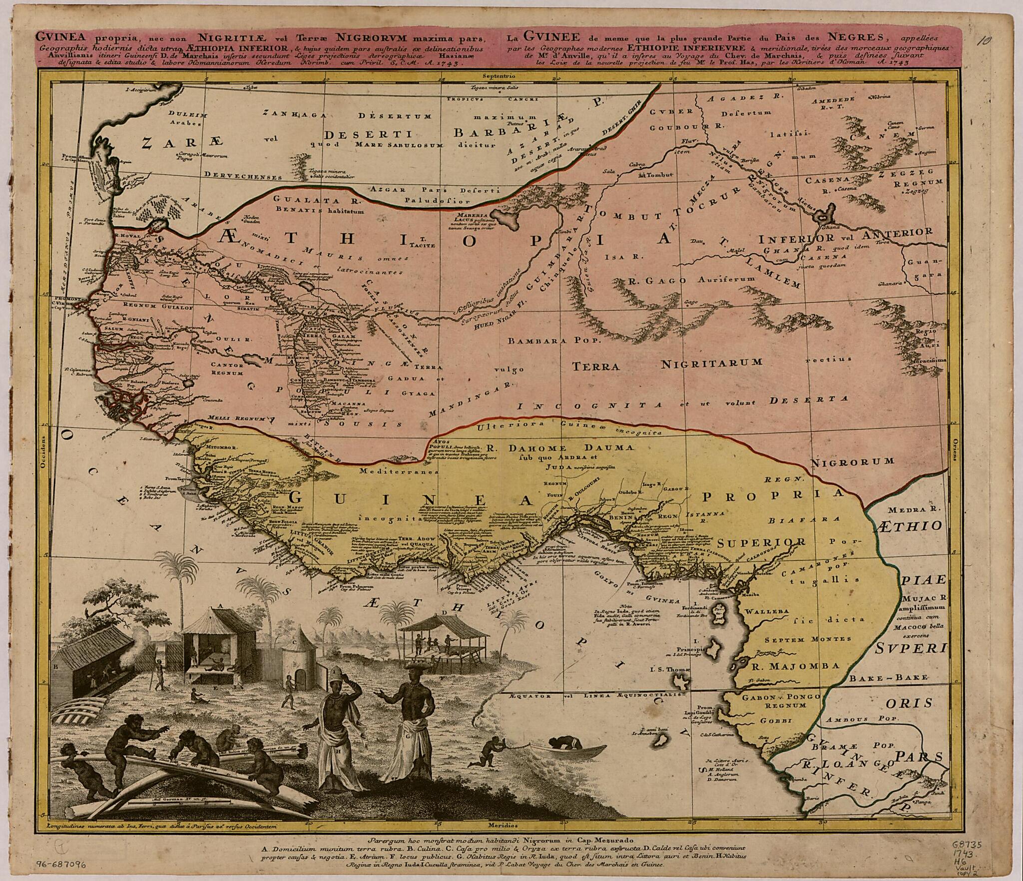
Old map of Africa, West, West Africa.day Gabon in the south to Niger, Mali, and Mauritania in the north. The map was published in Nuremberg, Germany, by the firm of Homännische Erben, meaning the successors of the Nuremberg engraver and publisher Johann Baptist Homann (1663-1724) and his son, Johann Christoph Homann (1703-30). It is based on an earlier work by the great French mapmaker Jean Baptiste d'Anville (1697-1782). The illustration at the lower left depicts an African village. Items such as dress, houses and other buildings, and economic activities are keyed by letter to an explanatory index, in Latin, at the bottom of the map. Place names and notes on the map are mainly in Latin, but in a few places French and Dutch also are used. The Gold Coast, for example, is identified as Littus Auri (Latin), Cote d'Or (French), and Goud Kust (Dutch). Ancient geographers referred to the whole of Africa as "Aethiopia," a name that, from the 15th century onward, gave way to the term Nigritia to designate the interior of the continent. This map uses both names." World Digital Library.
Created by Jean Baptiste Bourguignon D Anville, Homann Erben (Firm), R. De Marchais in 1743.
- Covers West Africa from Gabon in the south to Niger, Mali, and Mauritania in the north.
- Includes indexed ill. depicting the dress, dwellings, and work of native Africans.
- Prime meridian: Ferro.
- Relief shown pictorially.
- Three copies. Copy 1 has land areas colored green and yellow and border colored pink. Copy 2 has land areas colored pink and yellow, border colored yellow, and title/upper margin area colored pink; and "10" annotated in upper right corner. Copy 3 has land areas colored pink and yellow and border colored green; and "9" annotated in upper right corner.
Map Subjects
Africa West
Early Works To 1800
West Africa
Jean Baptiste Bourguignon D Anville
Homann Erben (Firm)
R. De Marchais
1743
- For the best legibility, order your map in the original size or larger. Most maps have intricate detail and small text that is best appreciated when the print size hasn't been reduced.
- Sizes labeled "Fits a Standard Frame" will drop right into any frame that you purchase in that size. The sizes that we offer are commonly available online and at most retail stores.
- Our standard sizes are recommendations based on the aspect ratio of the original map, but still may require some added "white space" in one dimension to fit.
- Non-standard sizes will require custom framing, and we suggest taking your print to the frame shop of your choice after you receive it for the best results.
- Custom sizes are available, simply contact us for a quote.
Below is an approximation of the scale of a few standard sizes, and how they might appear in your space.

