
Herat, Afghanistan 1880
- Regular price
-
$49.95 - Regular price
-
$34.95 - Sale price
-
$49.95
Buy one map, get any other map in our collection for 50% OFF! Add to cart to see discount.
Couldn't load pickup availability
About This Map
Discover the timeless beauty of our fine art quality printed reproduction of this antique map. Perfect for history enthusiasts, collectors, and interior decorators.
Restored with meticulous attention to detail by our team with over a decade of experience, this stunning reproduction captures the intricate artistry and historical significance of the original map.
Whether you're a collector or seeking a unique decor piece, this archival-quality map reproduction is a timeless addition to any space. Order now to bring history to life!
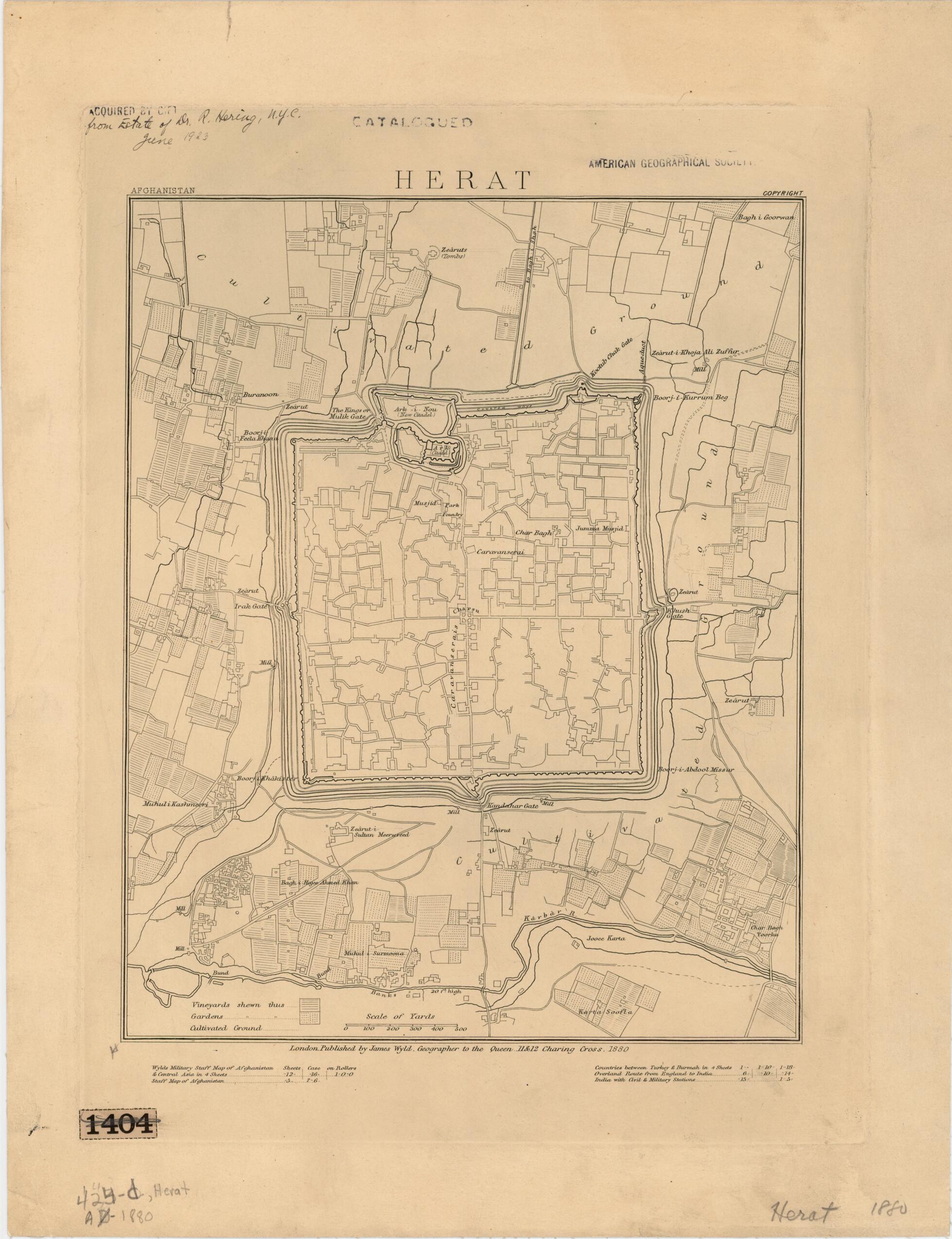
Old map of Afghanistan, Herat, Herāt.Afghan War (1878--80). The map depicts Herat's impressive defenses and its roughly square plan. The southern and most imposing part of the citadel, "the Ark" (from the Persian arg, citadel) remains standing and is one of the major landmarks of Herat, as is the Friday Mosque (the Jumma Musjid in northeastern Herat). The defensive walls have long been replaced by spacious boulevards, however. Also noteworthy are the extensive vineyards that surround the city along with gardens and other cultivated land. The governor of Herat, Ayub Khan (1857--1914), was the son of the Afghan ruler Sher Ali Khan, who died in 1879 while seeking the assistance of the Russians against the British forces that had invaded Afghanistan. Sher Ali Khan was succeeded by another son, Mohammad Yaqub Khan (reigned February--October 1879), who adopted a conciliatory policy toward the British. Ayub Khan refused to recognize the conciliatory policies of his brother, and in August 1880 struck the British forces at Maiwand, near Kandahar (483 kilometers to the southeast of Herat, as the crow flies). After inflicting a serious defeat on the British forces, Ayub Khan proceeded to lay siege to Kandahar in an engagement known as the Battle of Kandahar, but was defeated in early September of the same year. At his defeat, Ayub Khan was forced to seek asylum in Persia. The Battle of Kandahar marked the end of the Second Anglo-Afghan war, and allowed the British to help consolidate the power of ʻAbd al-Rahman Khan (also called Abdur Rahman, reigned 1880--1901) as ruler of Afghanistan. The map was produced by the famous British mapmaker James Wyld the younger (1812-87). After studying at the Royal Military Academy at Woolwich, he joined his father's mapmaking and publishing firm, which he eventually inherited. Wyld published numerous maps, many of which were intended to satisfy public interest in current events, such as the Anglo-Afghan wars, the California Gold Rush, and the Crimean War. Wyld's maps were of high quality, and he was appointed geographer to Queen Victoria and Prince Albert.
Created by James Wyld in 1880.
- Title devised, in English, by Library staff.
- "Scale 1:12,000"--Note extracted from World Digital Library.
- Original resource extent: 1 map ; sheet 44 x 34 centimeters.
- Original resource at: University of Wisconsin-Milwaukee Libraries.
- Content in English.
- Description based on data extracted from World Digital Library, which may be extracted from partner institutions.
- For the best legibility, order your map in the original size or larger. Most maps have intricate detail and small text that is best appreciated when the print size hasn't been reduced.
- Sizes labeled "Fits a Standard Frame" will drop right into any frame that you purchase in that size. The sizes that we offer are commonly available online and at most retail stores.
- Our standard sizes are recommendations based on the aspect ratio of the original map, but still may require some added "white space" in one dimension to fit.
- Non-standard sizes will require custom framing, and we suggest taking your print to the frame shop of your choice after you receive it for the best results.
- Custom sizes are available, simply contact us for a quote.
Below is an approximation of the scale of a few standard sizes, and how they might appear in your space.

