
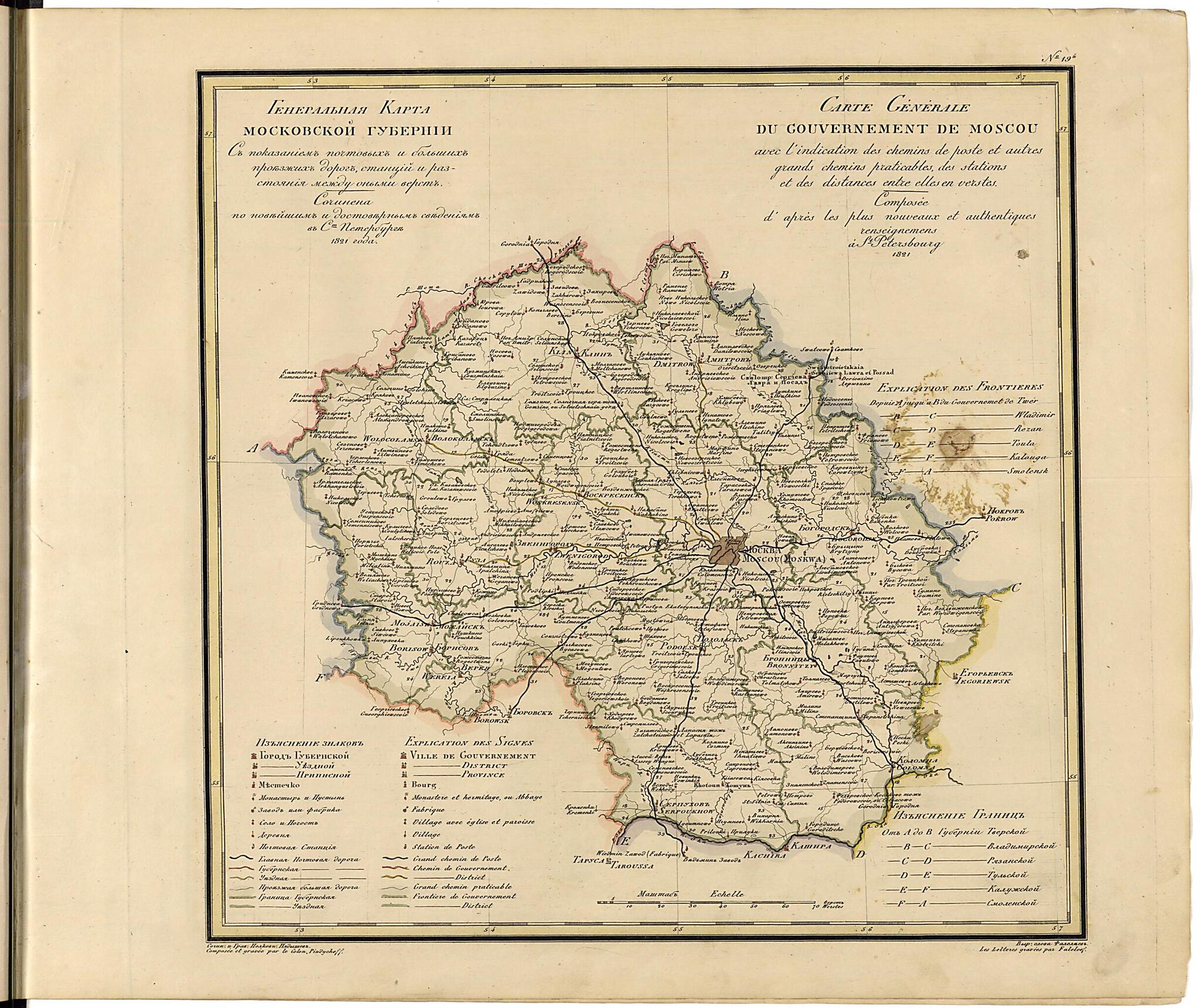
Generalʹnai︠a︡ Karta Moskovskoĭ Gubernii Sʺ Pokazaniemʺ Pochtovykhʺ I Bolʹshikhʺ Proi︠e︡zzhikhʺ Dorogʺ, Stant︠s︡iĭ I Razstoi︠a︡nii︠a︡ Mezhdu Onymi Verstʺ. (Генеральная Карта Московской Губе�...
- Regular price
-
$54.95 - Regular price
-
$33.95 - Sale price
-
$54.95
Buy one map, get any other map in our collection for 50% OFF! Add to cart to see discount.
Couldn't load pickup availability
About This Map
Discover the timeless beauty of our fine art quality printed reproduction of this antique map. Perfect for history enthusiasts, collectors, and interior decorators.
Restored with meticulous attention to detail by our team with over a decade of experience, this stunning reproduction captures the intricate artistry and historical significance of the original map.
Whether you're a collector or seeking a unique decor piece, this archival-quality map reproduction is a timeless addition to any space. Order now to bring history to life!
Old map of Moscow, Moscow Oblast, Russian Federation.names are in Russian and French. The prince of Suzdal', YuryVladimirovich(known as Yury Dolgoruky), founded Moscow in the mid-12th century as a fortified outpost for his realm in the northern reaches of Kievan Rus'. Moscow rose in prominence as many of its neighboring cities were sacked by the Mongols in the 13th century. The princes of Moscow were masterful in the complicated politics of the Golden Horde and advanced their interests through subtle negotiations and service to the khans in Sarai. In the late 14th century, Dmitrii Donskoi raised an army and inflicted the first major Russian military defeat on the Mongols at the Battle of Kulikovo in 1380. Thereafter, the grand princes of Muscovy stopped paying tribute to the Golden Horde and began the process of the "gathering of Russian lands" with Moscow as the effective national capital, which gained pace in earnest under Ivan the Great in the late 15th century. Ivan the Terrible became the first Russian tsar in the mid-16th century, and continued the expansion of Muscovy into the Lower Volga and ultimately into Siberia. Upon the fall of Constantinople to the Ottoman Turks in 1453, Moscow also assumed the moniker of the "Third Rome" and by 1589, the seat of an Orthodox patriarch. In the early 18th century, Peter the Great turned westward and moved the national capital to his new city on the Baltic, Saint Petersburg. World Digital Library.
Created by Faleleef, Vasiliĭ Petrovich Pi︠a︡dyshev, Russia. General Staff. Military Topographical Depot in 1821.
- No. 19 Iz izdanii︠a︡: Geograficheskiĭ atlas Rossiĭskoĭ imperii, T︠S︡arstva Polʹskago i Velikago Kni︠a︡zhestva Finli︠a︡ndskogo. Raspolozhennyĭ po gubernii︠a︡m na dvukh i︠a︡zykakh s oznacheniem v onykh gorodov, mestechek, sel, derevenʹ i vsekh primechatelʹneĭshikh mest; pochtovykh i bolʹshikh proezzhikh dorog, stant︠s︡iĭ i razstoi︠a︡niĭ mezhdu onymi, i prochimi selenii︠a︡mi v verstakh i mili︠a︡kh. Na 70 listakh s Generalʹnoi︠u︡ kartoi︠u︡ i Tablit︠s︡ei︠u︡ razstoi︠a︡nii︠a︡ verst po pochtovym dorogam mezhdu znatneĭshimi gorodami. Sochinen po noveĭshim i dostovernym svedenii︠a︡m, v polʹzu obuchai︠u︡shchikhsi︠a︡ Rossiĭskoĭ Geografii i dli︠a︡ sostavlenii︠a︡ dorozhnikov puteshestvennikam, Sluzhashchim v Voenno-topograficheskom Depo, Svity Ego Imperatorskago Velichestva po kvartirmeĭsterskoĭ chasti Podpolkovnikom Pi︠a︡dyshevym, 1821 goda. [SPb., 1820-1827]. Gravi︠u︡ra, raskrashena. Kartograficheskai︠a︡ setka cherez 1°; schet dolgot ot Ferro. Parallelʹno na frant︠s︡uzskom i︠a︡zyke.
- Uslovnye znaki: naselennye punkty (6 grupp), monastyri i pustyni, zavody i fabriki, pochtovye stant︠s︡ii, dorogi (4 vida), granit︠s︡y (gubernskai︠a︡, uezdnai︠a︡). Ukazatelʹ: Izʺi︠a︡snenie granit︠s︡ (A-F).
- Original map at: National Library of Russia
- From the atlas "Географической атласъ Россiйской Имперiи, Царства Польскаго и Великаго княжества Финляндскаго."
- No. 19 Из издания: Географический атлас Российской империи, Царства Польскаго и Великаго Княжества Финляндского. Расположенный по губерниям на двух языках с означением в оных городов, местечек, сел, деревень и всех примечательнейших мест; почтовых и больших проезжих дорог, станций и разстояний между оными, и прочими селениями в верстах и милях. На 70 листах с Генеральною картою и Таблицею разстояния верст по почтовым дорогам между знатнейшими городами. Сочинен по новейшим и достоверным сведениям, в пользу обучающихся Российской Географии и для составления дорожников путешественникам, Служащим в Военно-топографическом Депо, Свиты Его Императорскаго Величества по квартирмейстерской части Подполковником Пядышевым, 1821 года. [СПб., 1820-1827]. Гравюра, раскрашена. Картографическая сетка через 1°; счет долгот от Ферро. Параллельно на французском языке.
- Условные знаки: населенные пункты (6 групп), монастыри и пустыни, заводы и фабрики, почтовые станции, дороги (4 вида), границы (губернская, уездная). Указатель: Изъяснение границ (А-F).
Map Subjects
Atlases
Moscow
Moscow Oblast
Russian Federation
Siberia
Faleleef
Vasiliĭ Petrovich Pi︠a︡dyshev
Russia. General Staff. Military Topographical Depot
1821
- For the best legibility, order your map in the original size or larger. Most maps have intricate detail and small text that is best appreciated when the print size hasn't been reduced.
- Sizes labeled "Fits a Standard Frame" will drop right into any frame that you purchase in that size. The sizes that we offer are commonly available online and at most retail stores.
- Our standard sizes are recommendations based on the aspect ratio of the original map, but still may require some added "white space" in one dimension to fit.
- Non-standard sizes will require custom framing, and we suggest taking your print to the frame shop of your choice after you receive it for the best results.
- Custom sizes are available, simply contact us for a quote.
Below is an approximation of the scale of a few standard sizes, and how they might appear in your space.

