
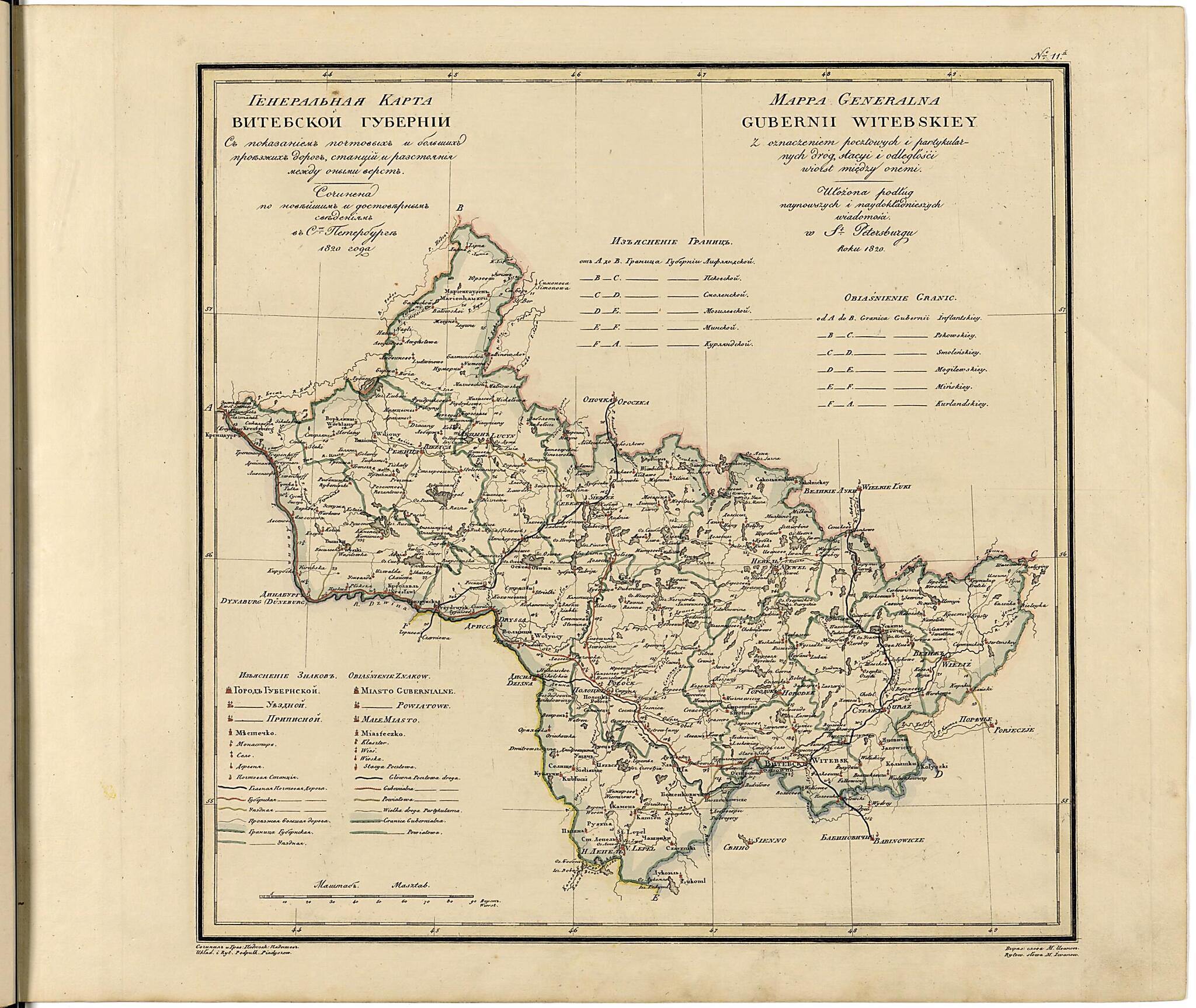
Generalʹnai︠a︡ Karta Vitebskoĭ Gubernii Sʺ Pokazaniemʺ Pochtovykhʺ I Bolʹshikhʺ Proi︠e︡zzhikhʺ Dorogʺ, Stant︠s︡iĭ I Razstoi︠a︡nii︠a︡ Mezhdu Onymi Verstʺ. (Генеральная Карта Витебской Губерн...
- Regular price
-
$54.95 - Regular price
-
$32.95 - Sale price
-
$54.95
Buy one map, get any other map in our collection for 50% OFF! Add to cart to see discount.
Couldn't load pickup availability
About This Map
Discover the timeless beauty of our fine art quality printed reproduction of this antique map. Perfect for history enthusiasts, collectors, and interior decorators.
Restored with meticulous attention to detail by our team with over a decade of experience, this stunning reproduction captures the intricate artistry and historical significance of the original map.
Whether you're a collector or seeking a unique decor piece, this archival-quality map reproduction is a timeless addition to any space. Order now to bring history to life!
Old map of Belarus, Russian Federation, Vitsyebskaya Voblasts.names are in Russian and Polish. The territory depicted on the map lies within present-day Belarus. Vitebsk is mentioned in early chronicles as having been founded in the tenth century. It developed as a semi-independent principality in the Middle Ages, influenced by neighboring polities in Kiev, Polotsk, and Smolensk. Its location on the river systems traversing the lands between the Baltic and Black Seas gave the region prominence and wealth already during Viking times. After the 14th century, Vitebsk fell under the sway of the Grand Duchy of Lithuania and later the Polish-Lithuanian Commonwealth. Vitebsk and the surrounding region became part of the Russian Empire after the First Partition of Poland in 1772, when Vitebsk Province was established. World Digital Library.
Created by Iwanoff, Vasiliĭ Petrovich Pi︠a︡dyshev, Russia. General Staff. Military Topographical Depot in 1820.
- No. 11 Iz izdanii︠a︡: Geograficheskiĭ atlas Rossiĭskoĭ imperii, T︠S︡arstva Polʹskago i Velikago Kni︠a︡zhestva Finli︠a︡ndskogo. Raspolozhennyĭ po gubernii︠a︡m na dvukh i︠a︡zykakh s oznacheniem v onykh gorodov, mestechek, sel, derevenʹ i vsekh primechatelʹneĭshikh mest; pochtovykh i bolʹshikh proezzhikh dorog, stant︠s︡iĭ i razstoi︠a︡niĭ mezhdu onymi, i prochimi selenii︠a︡mi v verstakh i mili︠a︡kh. Na 70 listakh s Generalʹnoi︠u︡ kartoi︠u︡ i Tablit︠s︡ei︠u︡ razstoi︠a︡nii︠a︡ verst po pochtovym dorogam mezhdu znatneĭshimi gorodami. Sochinen po noveĭshim i dostovernym svedenii︠a︡m, v polʹzu obuchai︠u︡shchikhsi︠a︡ Rossiĭskoĭ Geografii i dli︠a︡ sostavlenii︠a︡ dorozhnikov puteshestvennikam, Sluzhashchim v Voenno-topograficheskom Depo, Svity Ego Imperatorskago Velichestva po kvartirmeĭsterskoĭ chasti Podpolkovnikom Pi︠a︡dyshevym, 1821 goda. [SPb., 1820-1827]. Gravi︠u︡ra, raskrashena. Kartograficheskai︠a︡ setka cherez 1°; schet dolgot ot Ferro. Parallelʹno na polʹskom i︠a︡zyke.
- Uslovnye znaki: naselennye punkty (6 grupp), monastyri, pochtovye stant︠s︡ii, dorogi (4 vida), granit︠s︡y (gubernskai︠a︡, uezdnai︠a︡). Ukazatelʹ: Izʺi︠a︡snenie granit︠s︡ (A-F).
- Original map at: National Library of Russia
- From the atlas "Географической атласъ Россiйской Имперiи, Царства Польскаго и Великаго княжества Финляндскаго."
- No. 11 Из издания: Географический атлас Российской империи, Царства Польскаго и Великаго Княжества Финляндского. Расположенный по губерниям на двух языках с означением в оных городов, местечек, сел, деревень и всех примечательнейших мест; почтовых и больших проезжих дорог, станций и разстояний между оными, и прочими селениями в верстах и милях. На 70 листах с Генеральною картою и Таблицею разстояния верст по почтовым дорогам между знатнейшими городами. Сочинен по новейшим и достоверным сведениям, в пользу обучающихся Российской Географии и для составления дорожников путешественникам, Служащим в Военно-топографическом Депо, Свиты Его Императорскаго Величества по квартирмейстерской части Подполковником Пядышевым, 1821 года. [СПб., 1820-1827]. Гравюра, раскрашена. Картографическая сетка через 1°; счет долгот от Ферро. Параллельно на польском языке.
- Условные знаки: населенные пункты (6 групп), монастыри, почтовые станции, дороги (4 вида), границы (губернская, уездная). Указатель: Изъяснение границ (А-F).
Map Subjects
Atlases
Belarus
Russian Federation
Siberia
Vitsyebskaya Voblasts
Iwanoff
Vasiliĭ Petrovich Pi︠a︡dyshev
Russia. General Staff. Military Topographical Depot
1820
- For the best legibility, order your map in the original size or larger. Most maps have intricate detail and small text that is best appreciated when the print size hasn't been reduced.
- Sizes labeled "Fits a Standard Frame" will drop right into any frame that you purchase in that size. The sizes that we offer are commonly available online and at most retail stores.
- Our standard sizes are recommendations based on the aspect ratio of the original map, but still may require some added "white space" in one dimension to fit.
- Non-standard sizes will require custom framing, and we suggest taking your print to the frame shop of your choice after you receive it for the best results.
- Custom sizes are available, simply contact us for a quote.
Below is an approximation of the scale of a few standard sizes, and how they might appear in your space.

