
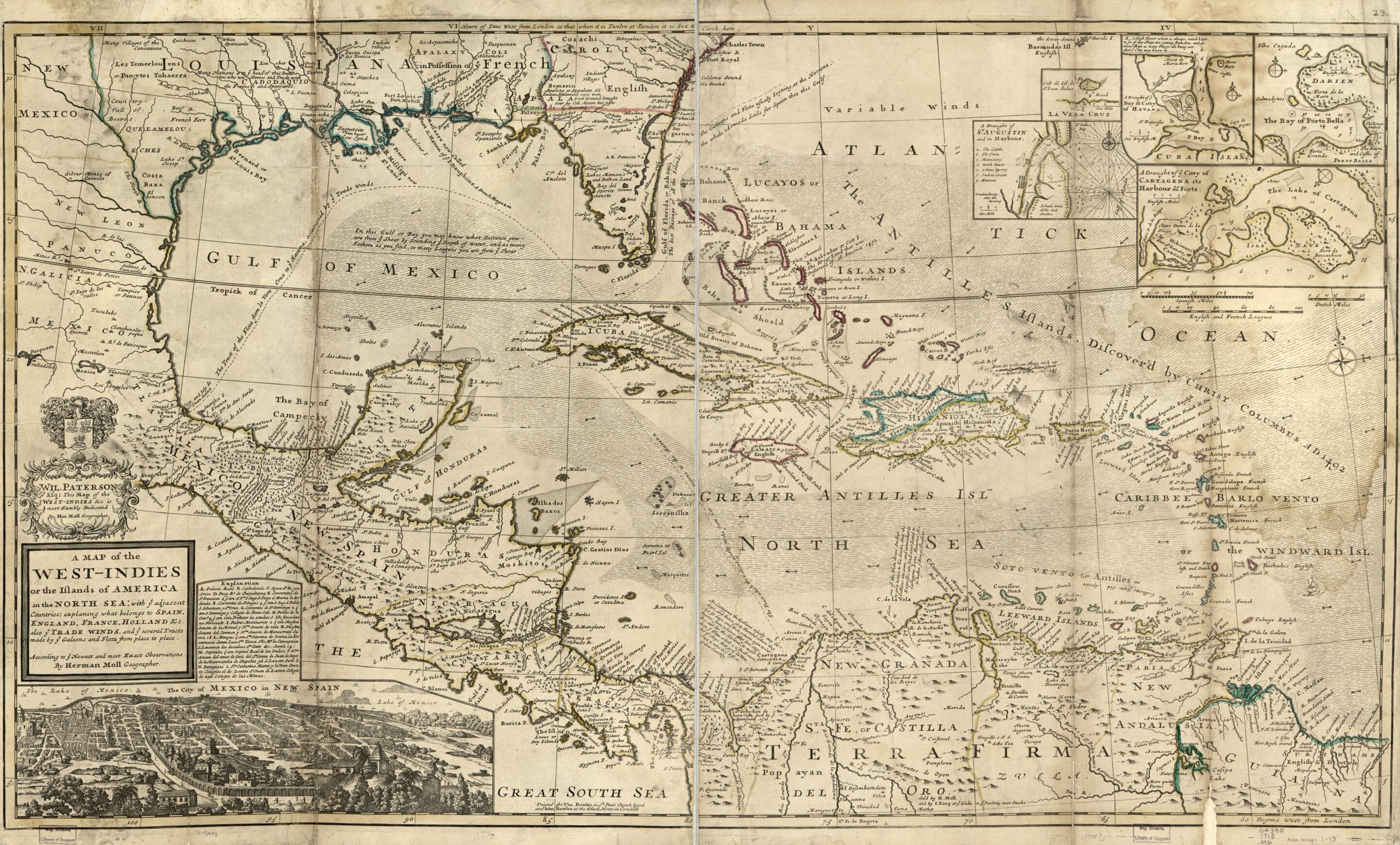
Indies Or the Islands of America In the North Sea; With Ye Adjacent Countries; Explaning sic What Belongs to Spain, England, France, Holland, &c. Also Ye Trade Winds, and Ye Several Tracts Made by Ye Galeons and Flota From Place to Place in 1715
- Regular price
-
$101.95 - Regular price
-
$96.95 - Sale price
-
$101.95
Buy one map, get any other map in our collection for 50% OFF! Add to cart to see discount.
Couldn't load pickup availability
About This Map
Discover the timeless beauty of our fine art quality printed reproduction of this antique map. Perfect for history enthusiasts, collectors, and interior decorators.
Restored with meticulous attention to detail by our team with over a decade of experience, this stunning reproduction captures the intricate artistry and historical significance of the original map.
Whether you're a collector or seeking a unique decor piece, this archival-quality map reproduction is a timeless addition to any space. Order now to bring history to life!
Old map of Caribbean Area, West Indies.Created by Thomas Bowles, Herman Moll in 1715.
- Scale ca. 1:5,500,000.
- Hand colored.
- Relief shown pictorially.
- "Printed for Tho: Bowles in St. Pauls Church Yard and Iohn Bowles at the Black Horse in Cornhill."
- "To Wil. Paterson, Esq; this map of the West Indies &c. is most humbly dedicated by Her. Moll, geographer."
- Insets: La Vera Cruz.--A draught of ye bay & citty of Havana.--[The bay of Porto Bella]--A draught of St. Augustin and its harbour.--A draught of ye citty of Cartagena its harbour & forts.--The city of Mexico in New Spain.
- For the best legibility, order your map in the original size or larger. Most maps have intricate detail and small text that is best appreciated when the print size hasn't been reduced.
- Sizes labeled "Fits a Standard Frame" will drop right into any frame that you purchase in that size. The sizes that we offer are commonly available online and at most retail stores.
- Our standard sizes are recommendations based on the aspect ratio of the original map, but still may require some added "white space" in one dimension to fit.
- Non-standard sizes will require custom framing, and we suggest taking your print to the frame shop of your choice after you receive it for the best results.
- Custom sizes are available, simply contact us for a quote.
Below is an approximation of the scale of a few standard sizes, and how they might appear in your space.
