
Iran. Eastern Half Including Afghanistan, Baluchistan, and the Uzbek Khanate On the Oxus. (Iran. Östliche Halfte Enthaltend Afghanistan, Balutschistan, Und Die Özbeghischen Khanate Am Oxus) 1878
- Regular price
-
$65.95 - Regular price
-
$60.95 - Sale price
-
$65.95
Buy one map, get any other map in our collection for 50% OFF! Add to cart to see discount.
Couldn't load pickup availability
About This Map
Discover the timeless beauty of our fine art quality printed reproduction of this antique map. Perfect for history enthusiasts, collectors, and interior decorators.
Restored with meticulous attention to detail by our team with over a decade of experience, this stunning reproduction captures the intricate artistry and historical significance of the original map.
Whether you're a collector or seeking a unique decor piece, this archival-quality map reproduction is a timeless addition to any space. Order now to bring history to life!
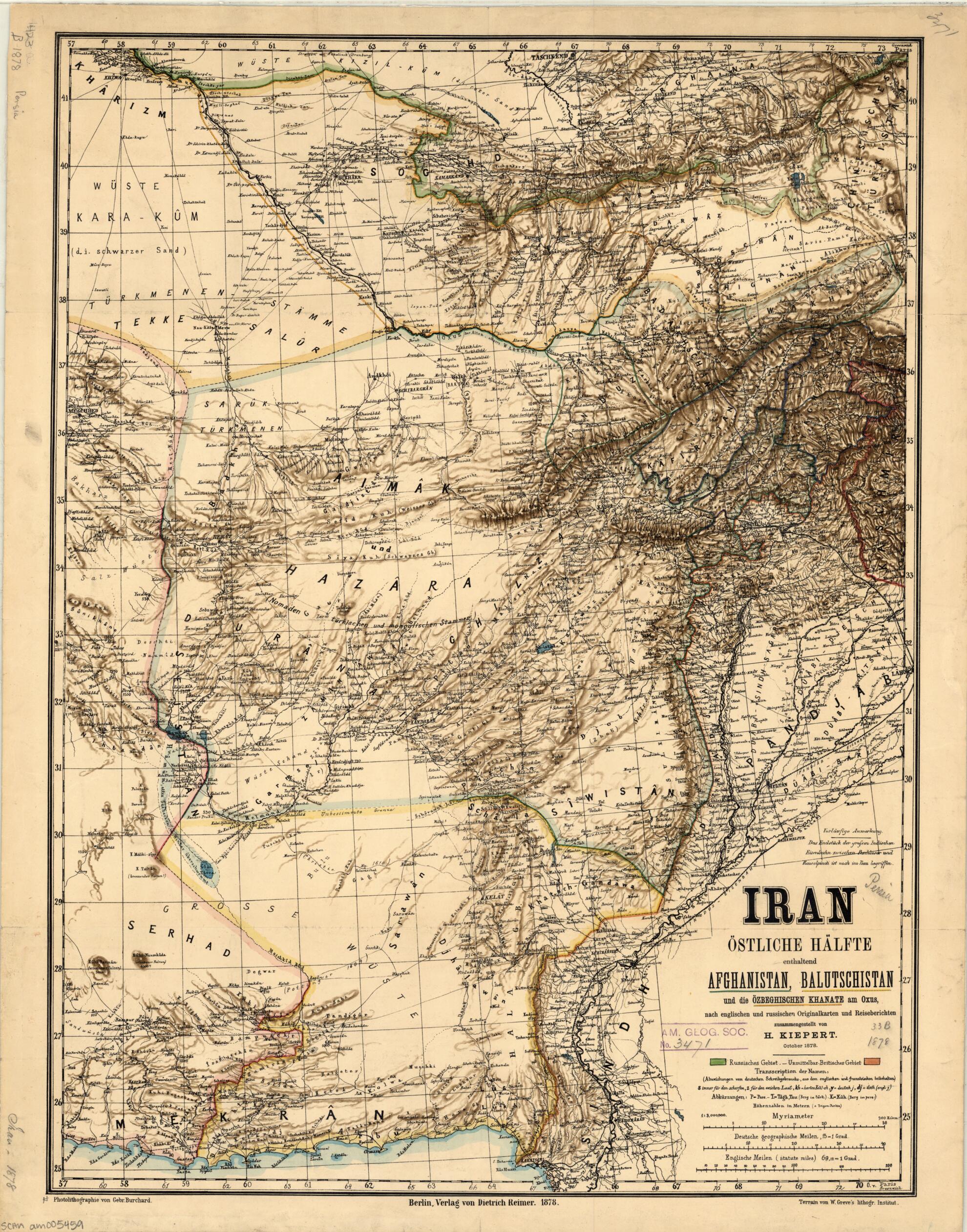
Old map of Afghanistan, Iran, Islamic Republic of, Pakistan, Turkmenistan, Uzbekistan.99), was a German geographer, who published several atlases of the ancient world during his career. The title, Iran. Östliche halfte enthaltend Afghanistan, Balutschistan, und die Özbeghischen Khanate am Oxus (Iran. Eastern Half Including Afghanistan, Baluchistan, and the Uzbek Khanate on the Oxus), can perhaps be understood in terms of historic Persian claims over parts of Afghanistan and Baluchistan, dating from the Safavid and Afsharid dynasties of Persia. Given the author's interest in ancient history, it is also possible that, in choosing his title, he was referring to the history of the ancient world and the Achaemenid Empire of Persia (550-330 BC). Whatever the case, prior to the publication of this map the ruling Qajar dynasty of Persia had ceded its claims to Afghanistan in the Treaty of Paris (1857), concluded with Great Britain after the Anglo-Persian War of 1856-57. Persia also later ceded large parts of the Makran coast (in 1863) and Baluchistan (in 1872) directly to British India. Shading in different colors is used to indicate the Russian and British spheres of influence. The map shows international borders, important cities, mountains, and railroads. The note above the title indicates that "the final section of the great Indian railroad from Peshawar to Rawalpindi is still under construction." Three distance scales are provided: kilometers, English statute miles, and German geographic miles. Kiepert was a professor of geography at Humboldt University in Berlin from 1854 until his death.
Created by Gebrueder Burchard, W. Greve, Heinrich Kiepert in 1878.
- Title devised, in English, by Library staff.
- "Scale 1:3,000,000"--Note extracted from World Digital Library.
- Original resource extent: 1 map : color ; 63 x 47 centimeters.
- Original resource at: University of Wisconsin-Milwaukee Libraries.
- Content in German.
- Description based on data extracted from World Digital Library, which may be extracted from partner institutions.
- For the best legibility, order your map in the original size or larger. Most maps have intricate detail and small text that is best appreciated when the print size hasn't been reduced.
- Sizes labeled "Fits a Standard Frame" will drop right into any frame that you purchase in that size. The sizes that we offer are commonly available online and at most retail stores.
- Our standard sizes are recommendations based on the aspect ratio of the original map, but still may require some added "white space" in one dimension to fit.
- Non-standard sizes will require custom framing, and we suggest taking your print to the frame shop of your choice after you receive it for the best results.
- Custom sizes are available, simply contact us for a quote.
Below is an approximation of the scale of a few standard sizes, and how they might appear in your space.

