
J. Sage & Son's New & Reliable Rail Road Map Comprising All the Railroads of the United States and Canadas With Their Stations and Distances 1858
- Regular price
-
$224.95 - Regular price
-
$219.95 - Sale price
-
$224.95
Buy one map, get any other map in our collection for 50% OFF! Add to cart to see discount.
Couldn't load pickup availability
About This Map
Discover the timeless beauty of our fine art quality printed reproduction of this antique map. Perfect for history enthusiasts, collectors, and interior decorators.
Restored with meticulous attention to detail by our team with over a decade of experience, this stunning reproduction captures the intricate artistry and historical significance of the original map.
Whether you're a collector or seeking a unique decor piece, this archival-quality map reproduction is a timeless addition to any space. Order now to bring history to life!
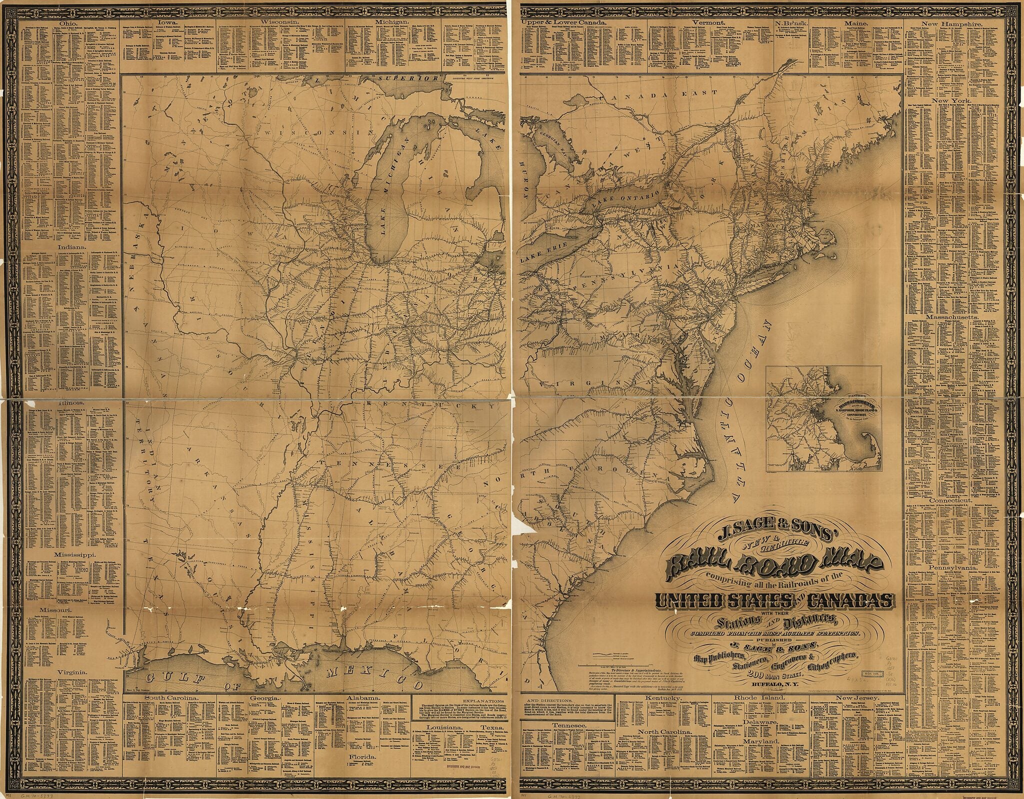
Outline commercial map of the eastern half of the United States framed in decorative borders indicating major drainage systems, state boundaries, cities and towns along railroad routes, and distances between stations. Includes detailed lists of railroad companies, stations, and distances by state in marginal text. [From published bibliography]Created by Sage (J.) & Sons, Hugo Stammann in 1858.
- Scale 1:2,112,000; 33 1/3 miles to an in.
- Shows railroads in operation, under construction, and projected.
- Note: "To Directors & Superintendents. The low price of this map must insure a large sale and as it will be printed in small editions, the publishers believe it to be the interest of the Rail Road Community to furnish us with sketches of all roads, or parts of roads that may be finished after this date, as well as notice of any changes of name or consolidation, and the proposed routes of Newly Chartered & progressing roads..."
- Differs from other edition in marginal text.
- Inset: "Eastern Massachusetts and part of N. Hampshire, Rhode Island & Connecticut on an enlarged scale." 15 x 17 cm.
Map Subjects
Railroads
United States
Sage (J.) & Sons
Hugo Stammann
1858
- For the best legibility, order your map in the original size or larger. Most maps have intricate detail and small text that is best appreciated when the print size hasn't been reduced.
- Sizes labeled "Fits a Standard Frame" will drop right into any frame that you purchase in that size. The sizes that we offer are commonly available online and at most retail stores.
- Our standard sizes are recommendations based on the aspect ratio of the original map, but still may require some added "white space" in one dimension to fit.
- Non-standard sizes will require custom framing, and we suggest taking your print to the frame shop of your choice after you receive it for the best results.
- Custom sizes are available, simply contact us for a quote.
Below is an approximation of the scale of a few standard sizes, and how they might appear in your space.

