
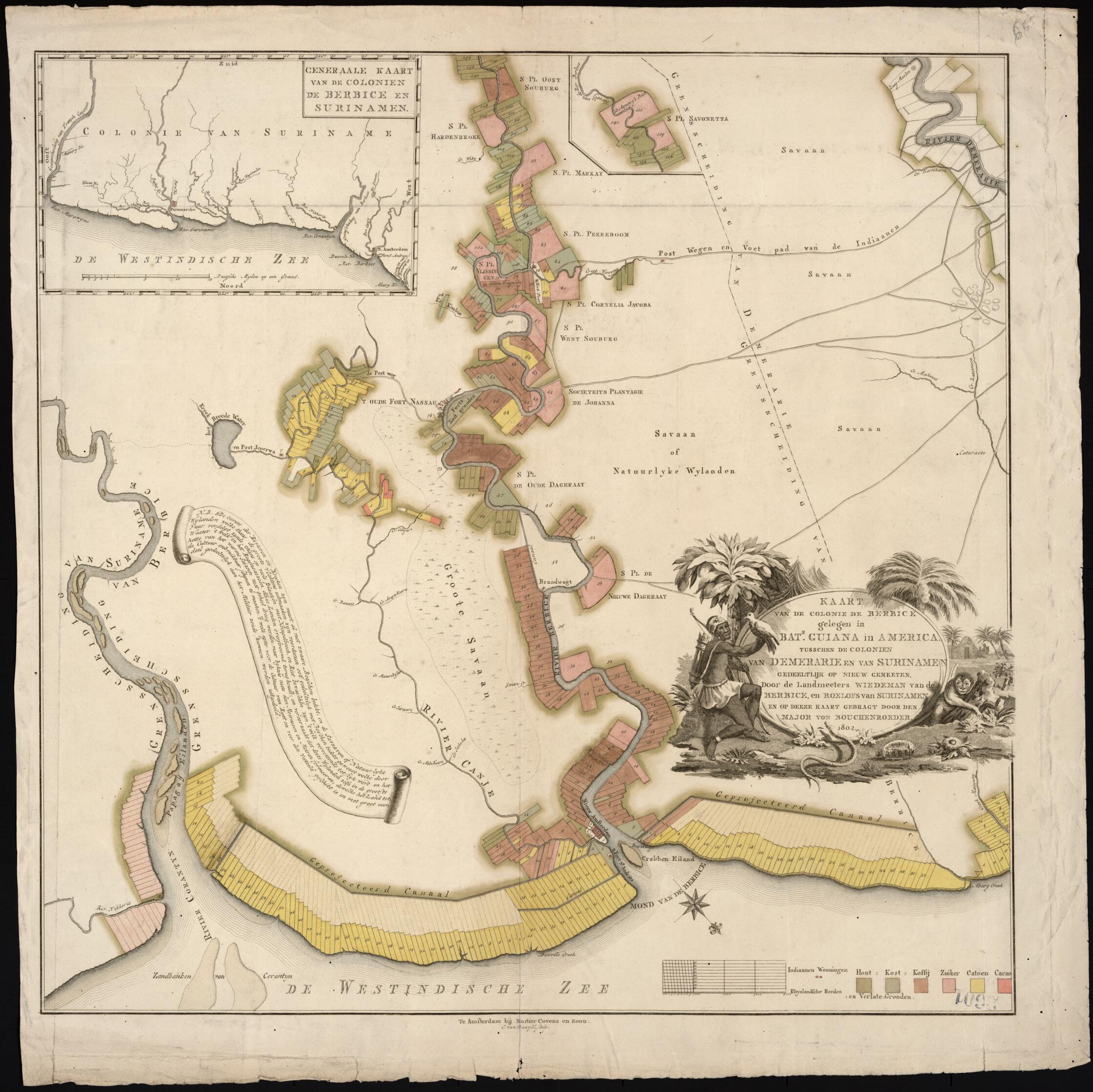
Map of the Colony of Berbice Located In Batavian Guiana In America Between the Colonies of Demerara and Suriname. (Kaart Van De Colonie De Berbice Gelegen In Bats. Guiana In America Tusschen De Colonien Van Demerarie En Van Surinamen) 1802
- Regular price
-
$125.95 - Regular price
-
$120.95 - Sale price
-
$125.95
Buy one map, get any other map in our collection for 50% OFF! Add to cart to see discount.
Couldn't load pickup availability
About This Map
Discover the timeless beauty of our fine art quality printed reproduction of this antique map. Perfect for history enthusiasts, collectors, and interior decorators.
Restored with meticulous attention to detail by our team with over a decade of experience, this stunning reproduction captures the intricate artistry and historical significance of the original map.
Whether you're a collector or seeking a unique decor piece, this archival-quality map reproduction is a timeless addition to any space. Order now to bring history to life!
Old map of Guyana, Suriname.day Guyana, Berbice was established in 1627 under the authority of the Dutch West India Company. The inset map in the upper left, oriented with north at the bottom, shows Berbice in relation to Suriname, its larger sister colony. The main map is oriented with north to the lower right. The names of the major plantations are given, with agricultural land indicated by the numbered, rectangular plots, which are located mainly along the river and the seacoast. Colors are used to show the different crops under cultivation, which include wood, coffee, sugar, cotton, and cacao. Also shown are savannas, post roads, Indian footpaths, a projected canal, Indian dwellings, forts, and the small settlement of New Amsterdam at the mouth of the Berbice River. In 1815, at the conclusion of the Napoleonic Wars, ownership of the colony passed to the British, who merged it with the neighboring colony of British Guiana (present-day Guyana).
Created by Cornelis Van Baarsel, Friedrich Von Bouchenroeder in 1802.
- Title devised, in English, by Library staff.
- Original resource at: Columbus Memorial Library, Organization of American States.
- Content in Dutch.
- Description based on data extracted from World Digital Library, which may be extracted from partner institutions.
- For the best legibility, order your map in the original size or larger. Most maps have intricate detail and small text that is best appreciated when the print size hasn't been reduced.
- Sizes labeled "Fits a Standard Frame" will drop right into any frame that you purchase in that size. The sizes that we offer are commonly available online and at most retail stores.
- Our standard sizes are recommendations based on the aspect ratio of the original map, but still may require some added "white space" in one dimension to fit.
- Non-standard sizes will require custom framing, and we suggest taking your print to the frame shop of your choice after you receive it for the best results.
- Custom sizes are available, simply contact us for a quote.
Below is an approximation of the scale of a few standard sizes, and how they might appear in your space.

