
Kandahar, Afghanistan 1880
- Regular price
-
$49.95 - Regular price
-
$34.95 - Sale price
-
$49.95
Buy one map, get any other map in our collection for 50% OFF! Add to cart to see discount.
Couldn't load pickup availability
About This Map
Discover the timeless beauty of our fine art quality printed reproduction of this antique map. Perfect for history enthusiasts, collectors, and interior decorators.
Restored with meticulous attention to detail by our team with over a decade of experience, this stunning reproduction captures the intricate artistry and historical significance of the original map.
Whether you're a collector or seeking a unique decor piece, this archival-quality map reproduction is a timeless addition to any space. Order now to bring history to life!
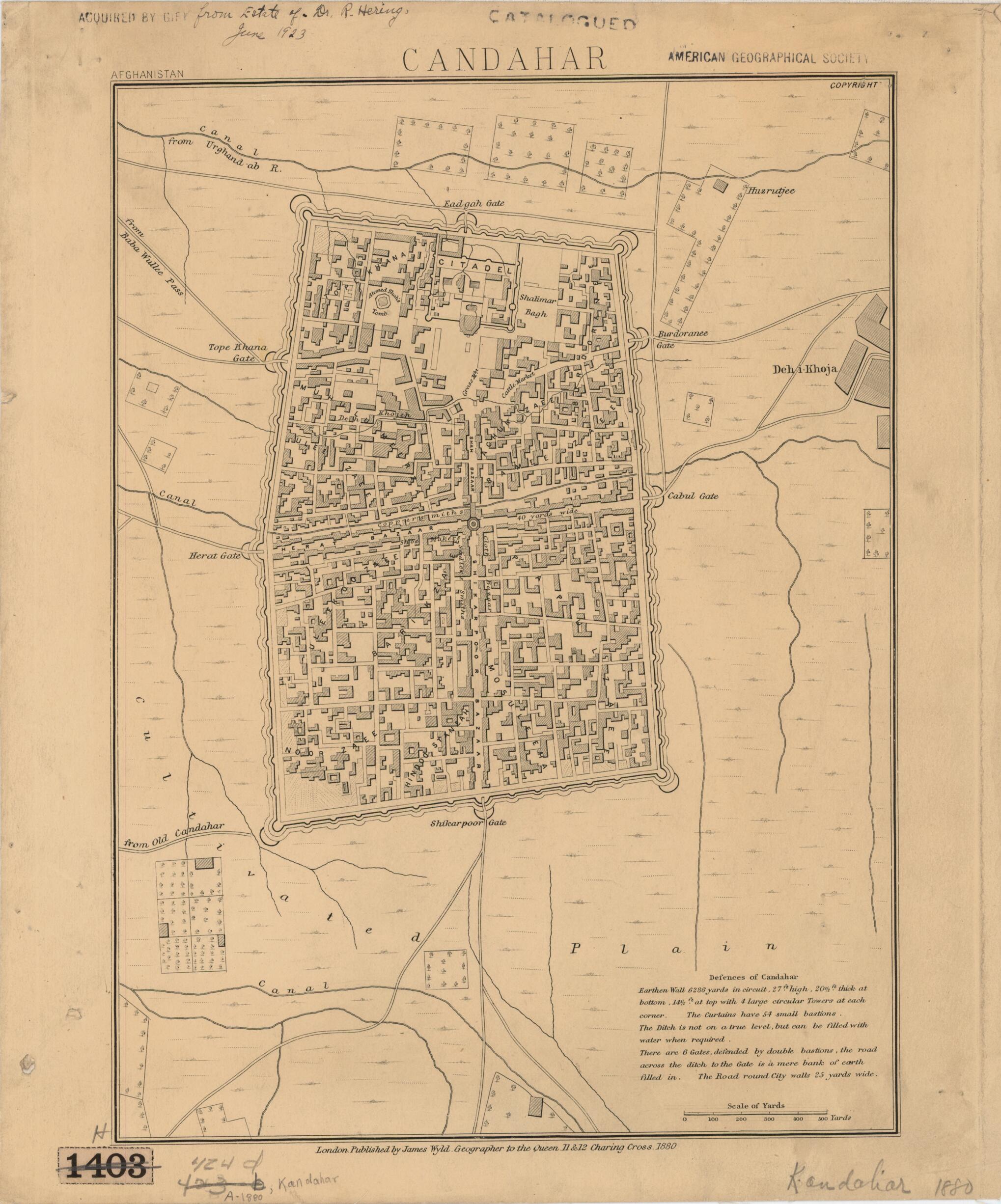
Old map of Afghanistan, Kandahar, Qandahār.Afghan War (1878--80). Soldiers stationed at the British garrison at Kandahar met Afghan forces at nearby Maiwand, where on July 27, 1880, the two British and Indian brigades suffered a calamitous defeat. Retreating to Kandahar, the surviving British soldiers drove away the local population and took shelter behind the protective walls in preparation for the defense of city. Ayub Khan, the ruler of Herat and the victor at Maiwand, proceeded to lay siege to Kandahar in early August 1880. The Battle of Kandahar, which lasted until September 1, resulted in the defeat of the Afghan forces, thanks in part to fresh British reinforcements from Kabul. This map, by the famous British mapmaker James Wyld the younger (1812--87), dates from 1880 and includes text describing the city's defenses. It is extremely detailed, showing individual groups of houses, the areas of the different trades, and markets. The fortified walls of the city, behind which the British forces took shelter during the battle, remained standing in parts until the early 20th century. The roughly rectangular layout of these fortifications can be traced in the modern city, where the walls have been replaced by streets and boulevards. Also noted on the map are the citadel (at the approximate site of the present-day governor's and police compound of Kandahar) and the nearby tomb of Ahmad Shah Durrani (circa 1722--72), the founder of modern Afghanistan. Kandahar is an ancient and storied city that was frequently fought over by warring empires. Its recorded history goes back at least to the sixth century BC, when the city served as the administrative capital of the province of Arachosia in the Persian Empire.
Created by James Wyld in 1880.
- Title devised, in English, by Library staff.
- "Scale 1:12,000"--Note extracted from World Digital Library.
- Original resource extent: 1 map ; 35 x 29 centimeters.
- Original resource at: University of Wisconsin-Milwaukee Libraries.
- Content in English.
- Description based on data extracted from World Digital Library, which may be extracted from partner institutions.
- For the best legibility, order your map in the original size or larger. Most maps have intricate detail and small text that is best appreciated when the print size hasn't been reduced.
- Sizes labeled "Fits a Standard Frame" will drop right into any frame that you purchase in that size. The sizes that we offer are commonly available online and at most retail stores.
- Our standard sizes are recommendations based on the aspect ratio of the original map, but still may require some added "white space" in one dimension to fit.
- Non-standard sizes will require custom framing, and we suggest taking your print to the frame shop of your choice after you receive it for the best results.
- Custom sizes are available, simply contact us for a quote.
Below is an approximation of the scale of a few standard sizes, and how they might appear in your space.

