
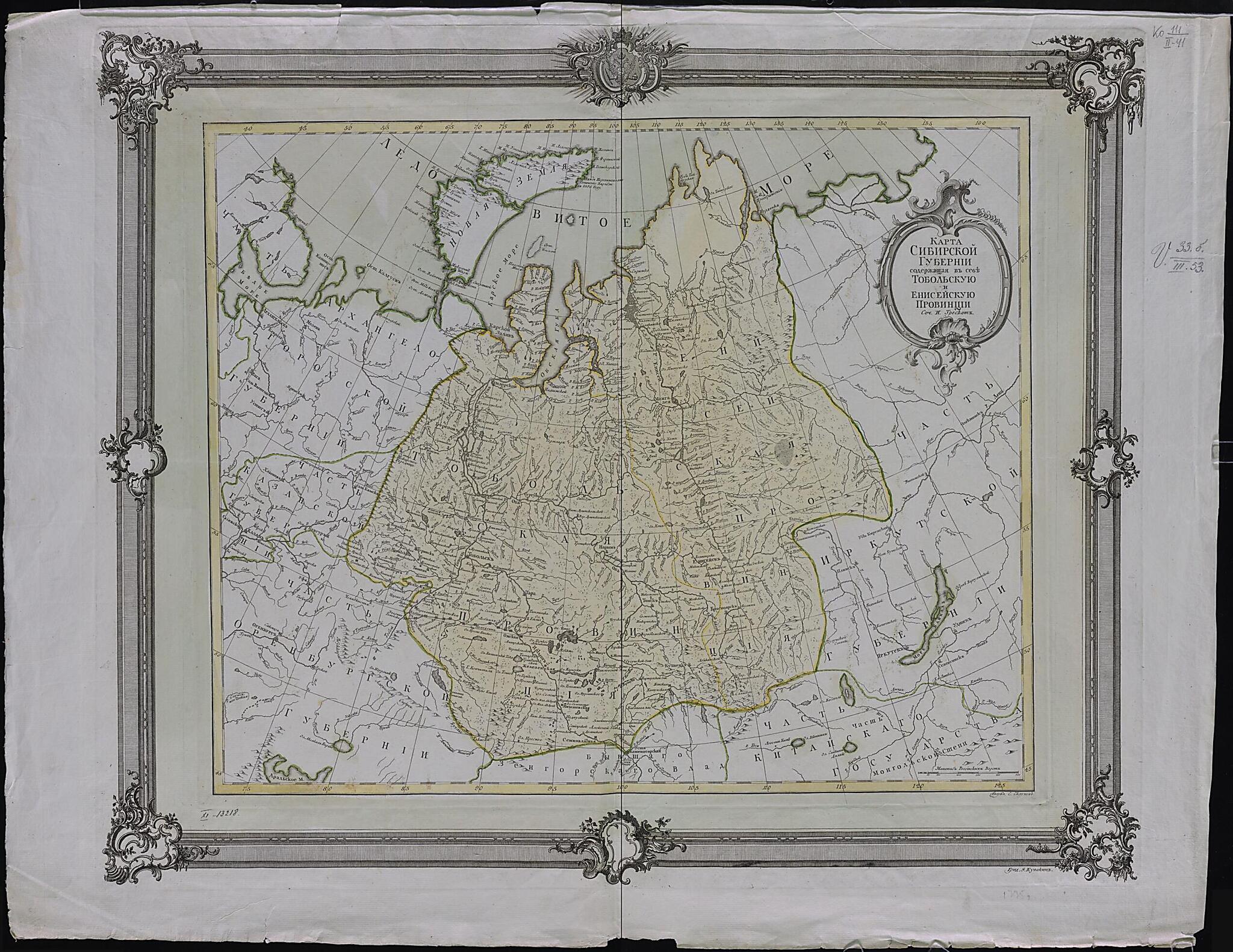
Karta Sibirskoĭ Gubernii, Soderzhashchai︠a︡ V Sebe Tobol'skui︠u︡ I Eniseĭskui︠u︡ Provint︠s︡ii. (Карта Сибирской губернии, содержащая в себе Тобольскую и Енисейскую прови�...
- Regular price
-
$88.95 - Regular price
-
$83.95 - Sale price
-
$88.95
Buy one map, get any other map in our collection for 50% OFF! Add to cart to see discount.
Couldn't load pickup availability
About This Map
Discover the timeless beauty of our fine art quality printed reproduction of this antique map. Perfect for history enthusiasts, collectors, and interior decorators.
Restored with meticulous attention to detail by our team with over a decade of experience, this stunning reproduction captures the intricate artistry and historical significance of the original map.
Whether you're a collector or seeking a unique decor piece, this archival-quality map reproduction is a timeless addition to any space. Order now to bring history to life!
Old map of Khanty, Mansi Autonomous Okrug, Nenetskiy Autonomous Okrug, Russian Federation, Yamalo, Yugra.86) and engraved by S. Sklunov in 1775. Gradients on the map were included by I. Kuvakin. Treskot was a talented geodesist, affiliated with the Geographical Department of the Russian Academy of Sciences. The symbol of Imperial Russia, the crest of a double-headed eagle holding the orb and scepter, adorns the center top of the map. Rivers, populated places, vegetation, and mountains are shown in detail for both Tobolsk and Yeniseysk Provinces, which are shaded in yellow and surrounded by a solid yellow borderline. Most rivers and tributaries, as well as lakes and other bodies of water, are named if located within these two provinces. Cities, towns, and other geographic points of interest are also extensively identified within Tobolsk and Yeniseysk Provinces. Similar cartographic indications are made for adjoining Russian regions shown in white rather than yellow, but are far fewer in number or detail. The shoreline of the Arctic Ocean along northern Russia is provided with a geographic specificity unusual for its era. The map indicates distance in versts, a tsarist-era unit of length equal to 1.07 kilometers. World Digital Library.
Created by Ivan Kuvakin, Johann Treskot in 1775.
- Obshchegeograficheskai︠a︡ karta, na kotoroĭ pobrobno pokazany reki, naselennye punkty, beregovai︠a︡ linii︠a︡ Severnogo Ledovitogo okeana. Karta pomeshchena v ramku i ukrashena gerbom Rossiĭskoĭ Imperii.
- Sochinil I. Truskot, vyrezyval S. Sklonov, gradiroval I. Kuvakin.
- Original map at: Russian State Library
- Общегеографическая карта, на которой побробно показаны реки, населенные пункты, береговая линия Северного Ледовитого океана. Карта помещена в рамку и украшена гербом Российской Империи.
- Сочинил И. Трускот, вырезывал С. Склонов, градировал И. Кувакин.
Map Subjects
Arctic Regions
Mansi Autonomous Okrug-Yugra
Russian Federation
Nenetskiy Autonomous Okrug
Khanty
Mansi Autonomous Okrug
Yamalo
Yugra
Ivan Kuvakin
Johann Treskot
1775
- For the best legibility, order your map in the original size or larger. Most maps have intricate detail and small text that is best appreciated when the print size hasn't been reduced.
- Sizes labeled "Fits a Standard Frame" will drop right into any frame that you purchase in that size. The sizes that we offer are commonly available online and at most retail stores.
- Our standard sizes are recommendations based on the aspect ratio of the original map, but still may require some added "white space" in one dimension to fit.
- Non-standard sizes will require custom framing, and we suggest taking your print to the frame shop of your choice after you receive it for the best results.
- Custom sizes are available, simply contact us for a quote.
Below is an approximation of the scale of a few standard sizes, and how they might appear in your space.

