
Kingdom of Galicia. (Gallæcia Regnum) 1619
- Regular price
-
$54.95 - Regular price
-
$30.95 - Sale price
-
$54.95
Buy one map, get any other map in our collection for 50% OFF! Add to cart to see discount.
Couldn't load pickup availability
About This Map
Discover the timeless beauty of our fine art quality printed reproduction of this antique map. Perfect for history enthusiasts, collectors, and interior decorators.
Restored with meticulous attention to detail by our team with over a decade of experience, this stunning reproduction captures the intricate artistry and historical significance of the original map.
Whether you're a collector or seeking a unique decor piece, this archival-quality map reproduction is a timeless addition to any space. Order now to bring history to life!
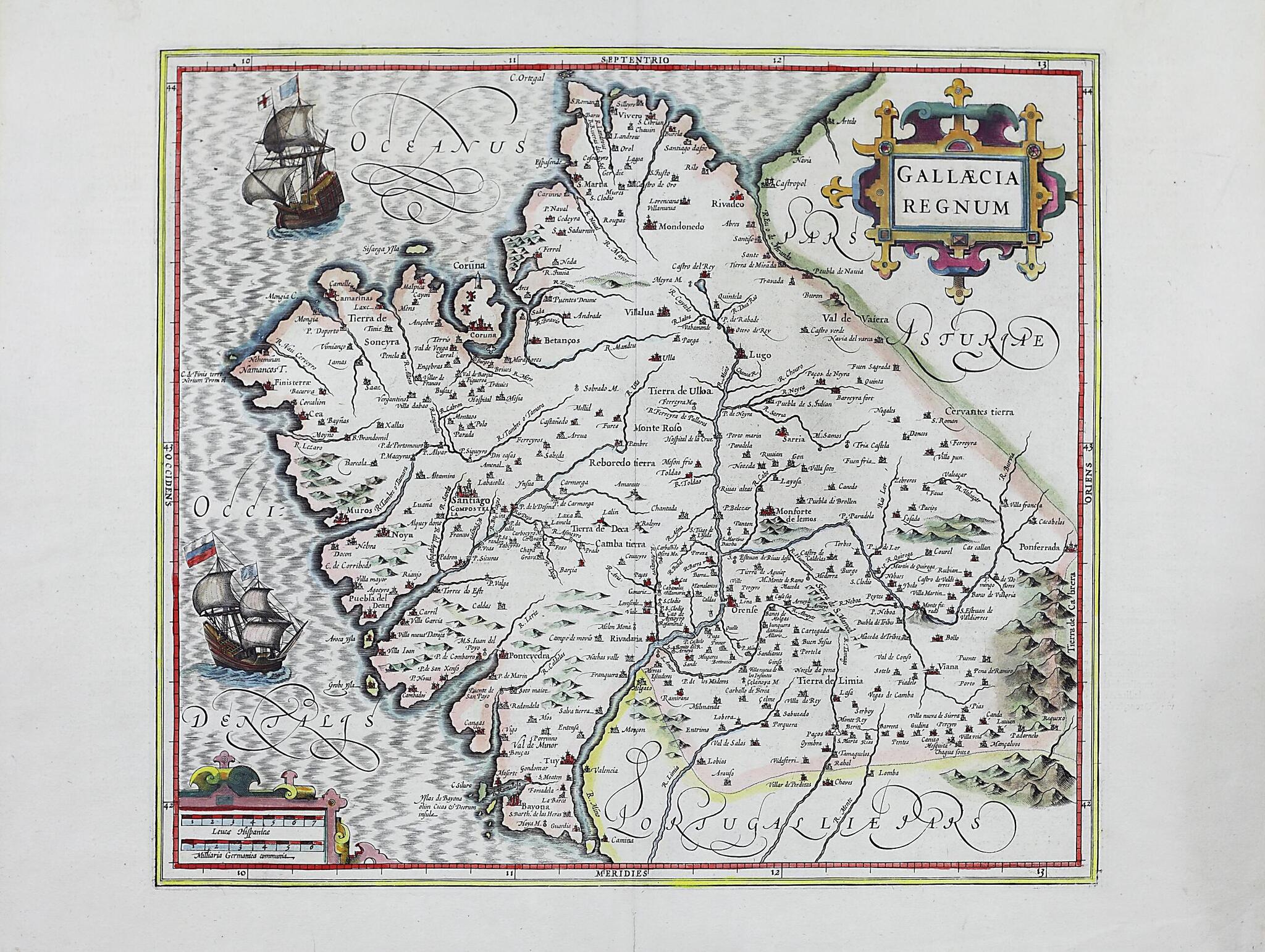
Old map of Galicia, Spain.1615). That map appeared in the Theatrum Orbis Terrarum (Theater of the world) of Abraham Ortelius (1527-98), in the edition by Antwerp publisher Jan Baptista Vrients of 1603. The map, despite its many errors, was not soon improved on, and was copied many times, giving rise to a long well-documented history. The version of the map presented here, "Gallaecia Regnum" (Kingdom of Gallicia), comes from the fourth edition of the Gerardi Mercatoris Atlas Sive Cosmographicae Meditationes De Fabrica Mundi et Fabricati Figura (Atlas of the world by Gerard Mercator: finely engraved and drawn), published around 1611 by Jodocus Hondius (1563-1612) following the work of Gerhard Mercator (1512-94). It is on a scale similar to the original and maintains the general configuration and the disproportion of some areas, but some slight changes are introduced in the profile of the western coast of Galicia, and in the larger number of mountains. The map title, legend, cardinal directions, and neighboring territories are given in Latin; the Atlantic is labeled Oceanus Occidentalis (Western Ocean). Place-names are in Spanish. Two of the most significant buildings shown are the Cathedral of Santiago de Compostela and the Tower of Hercules at La Coruña--the only fully preserved Roman lighthouse still in use for maritime signaling and a UNESCO World Heritage site. Scale is expressed in the legend in two units of measurement: seven Spanish leagues, and six German common miles, each equal to 6.2 centimeters. The verso, pages 117-18 from the Hondius-Mercator atlas, shows text in French entitled "Galice," with an ornate capital, and marginal headings. The text gives information about Galicia's climate, livestock, politics and government, towns, rivers, ports, mountains, and the major churches and public figures of Santiago de Compostela.
Created by Jodocus Hondius, Gerhard Mercator in 1619.
- Title devised, in English, by Library staff.
- Original resource extent: 1 map : hand colored ; 50 x 60 centimeters.
- Original resource at: Library of Galicia.
- Content in Latin and Spanish.
- Description based on data extracted from World Digital Library, which may be extracted from partner institutions.
Map Subjects
Atlantic Ocean
Galicia
Galleons
Sailing Ships
Ships
Spain
Jodocus Hondius
Gerhard Mercator
1619
- For the best legibility, order your map in the original size or larger. Most maps have intricate detail and small text that is best appreciated when the print size hasn't been reduced.
- Sizes labeled "Fits a Standard Frame" will drop right into any frame that you purchase in that size. The sizes that we offer are commonly available online and at most retail stores.
- Our standard sizes are recommendations based on the aspect ratio of the original map, but still may require some added "white space" in one dimension to fit.
- Non-standard sizes will require custom framing, and we suggest taking your print to the frame shop of your choice after you receive it for the best results.
- Custom sizes are available, simply contact us for a quote.
Below is an approximation of the scale of a few standard sizes, and how they might appear in your space.

