
Kyōto Pictorial 1686
- Regular price
-
$130.95 - Regular price
-
$125.95 - Sale price
-
$130.95
Buy one map, get any other map in our collection for 50% OFF! Add to cart to see discount.
Couldn't load pickup availability
About This Map
Discover the timeless beauty of our fine art quality printed reproduction of this antique map. Perfect for history enthusiasts, collectors, and interior decorators.
Restored with meticulous attention to detail by our team with over a decade of experience, this stunning reproduction captures the intricate artistry and historical significance of the original map.
Whether you're a collector or seeking a unique decor piece, this archival-quality map reproduction is a timeless addition to any space. Order now to bring history to life!
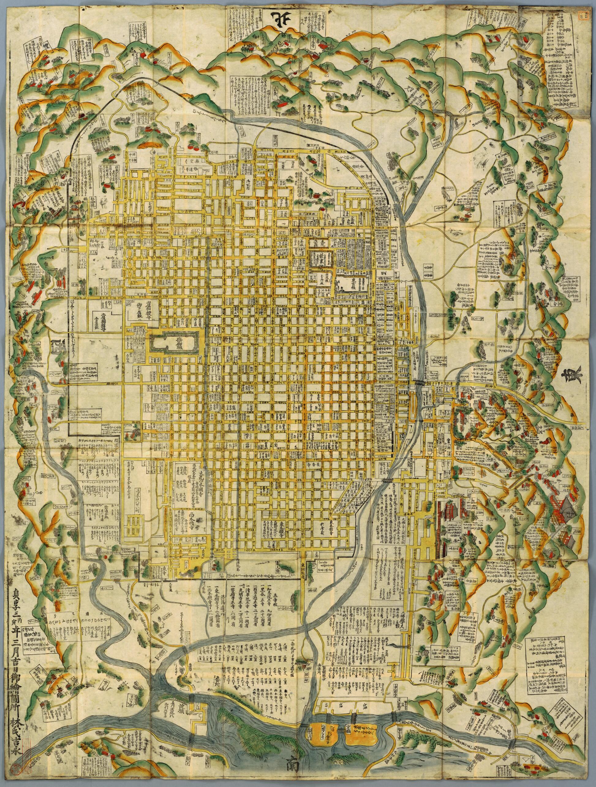
Old map of Japan, Kyoto.-1867). The publication of maps in Japan started in Kyōto at the beginning of the Edo period, and the first city map to be published was a map of Kyōto. The first Kyōto maps depicted just the urban area, but the scope of the maps gradually expanded to include suburban areas as well. This map depicts the peripheral suburban areas as well as the central urban area. The main feature of the map is the ingenuity with which the information displayed has been maximized while maintaining easy readability. In previous Kyōto maps the urban areas delimited by roads were painted in black. This was the first map to leave these areas blank, allowing for the inclusion of more information, such as temple names and the names of the owners of houses. As writing all the street names in the map would have required minute handwriting, the streets were marked with a character symbol in a circle and a list of the symbols with their corresponding street names was inserted in blank spaces on the map. The map could also be used as a tourist guidebook. The mountains and rivers outside the city are depicted in color and detailed explanations of famous places, such as Kiyomizudera (Kiyomizu Temple), are included along with pictorial depictions of the buildings. The size of the map would have made it awkward to carry around and the direction of the text varies, allowing it to be read from all sides. These factors suggest that it was intended to be spread out on the floor and viewed from any side.
- Title devised, in English, by Library staff.
- Original resource extent: 1 sheet ; 166 x 125 centimeters.
- Original resource at: National Diet Library.
- Content in Japanese.
- Description based on data extracted from World Digital Library, which may be extracted from partner institutions.
- For the best legibility, order your map in the original size or larger. Most maps have intricate detail and small text that is best appreciated when the print size hasn't been reduced.
- Sizes labeled "Fits a Standard Frame" will drop right into any frame that you purchase in that size. The sizes that we offer are commonly available online and at most retail stores.
- Our standard sizes are recommendations based on the aspect ratio of the original map, but still may require some added "white space" in one dimension to fit.
- Non-standard sizes will require custom framing, and we suggest taking your print to the frame shop of your choice after you receive it for the best results.
- Custom sizes are available, simply contact us for a quote.
Below is an approximation of the scale of a few standard sizes, and how they might appear in your space.

