
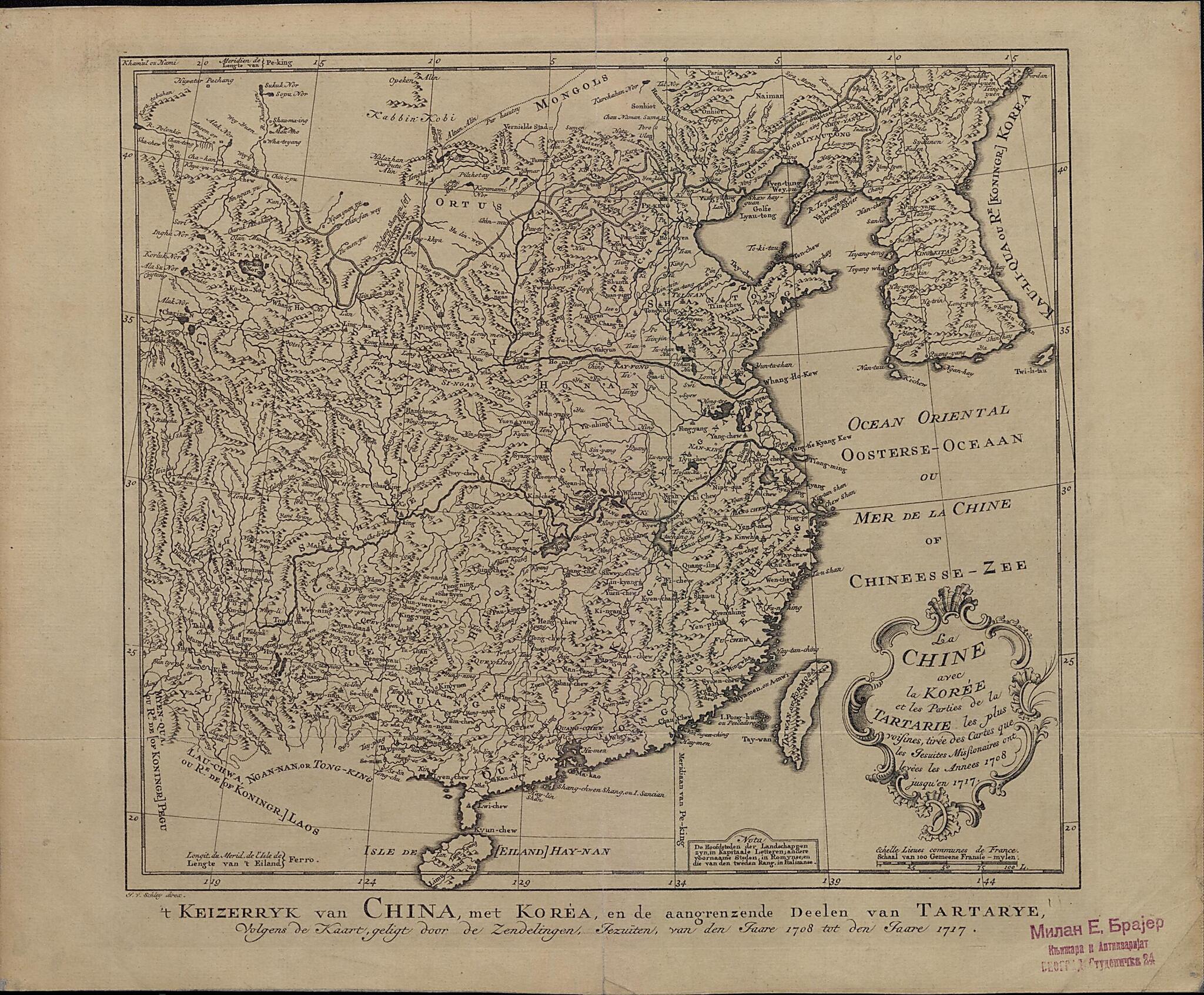
China, With Korea and Parts of Tartarstan: the Closest Parts, from the Maps Drawn by Jesuit Missionaries In the Years 1708 to 1717. (La Chine Avec La Korée Et Les Parties De La Tartarie : Les Plus Voisines, Tirée Des Cartes Que Les Jesuites Missiona...
- Regular price
-
$49.95 - Regular price
-
$34.95 - Sale price
-
$49.95
Buy one map, get any other map in our collection for 50% OFF! Add to cart to see discount.
Couldn't load pickup availability
About This Map
Discover the timeless beauty of our fine art quality printed reproduction of this antique map. Perfect for history enthusiasts, collectors, and interior decorators.
Restored with meticulous attention to detail by our team with over a decade of experience, this stunning reproduction captures the intricate artistry and historical significance of the original map.
Whether you're a collector or seeking a unique decor piece, this archival-quality map reproduction is a timeless addition to any space. Order now to bring history to life!
Old map of China, Democratic People's Republic of Korea, Mongolia, Republic of Korea.Baptiste Bourguignon d'Anville (1697-1782), the great cartographer, geographer, and map collector, to compile his Nouvel atlas de la Chine, de la Tartarie Chinoise et du Thibet (New atlas of China, Chinese Tartary, and Tibet). This atlas was published in Holland in 1737 as a companion work to Father J.-B. Du Halde's Description géographique, historique, chronologique, politique, et physique de l'empire de la Chine (Geographic, historical, chronological, political, and physical description of the Chinese Empire), published in 1735. The map presented here, of China, Korea, and the neighboring parts of Central Asia then known as Tartary, in Dutch and French, is an adaptation of one of D'Anville's maps. The subtitle, in Dutch at the bottom and in French in the cartouche, states that it is based on the Jesuit surveys. Place-names are in French and Dutch, with the Dutch translations sometimes given in brackets. The Great Wall, in northern China, is shown. The scale is in French leagues, and the prime meridian is set at Ferro Island, the southwestern-most of the Canary Islands.
Created by Baptiste Bourguignon D in 1737.
- Title devised, in English, by Library staff.
- "Linear scale 10,000,000"--Note extracted from World Digital Library.
- Original resource extent: 1 map ; 40 x 33 centimeters.
- Original resource at: National and University Library "St Kliment Ohridski" -- Skopje.
- Content in French and Dutch.
- Description based on data extracted from World Digital Library, which may be extracted from partner institutions.
Map Subjects
1708 To 1717
China
Democratic People's Republic Of Korea
Jesuits
Mongolia
Republic Of Korea
Baptiste Bourguignon D
1737
- For the best legibility, order your map in the original size or larger. Most maps have intricate detail and small text that is best appreciated when the print size hasn't been reduced.
- Sizes labeled "Fits a Standard Frame" will drop right into any frame that you purchase in that size. The sizes that we offer are commonly available online and at most retail stores.
- Our standard sizes are recommendations based on the aspect ratio of the original map, but still may require some added "white space" in one dimension to fit.
- Non-standard sizes will require custom framing, and we suggest taking your print to the frame shop of your choice after you receive it for the best results.
- Custom sizes are available, simply contact us for a quote.
Below is an approximation of the scale of a few standard sizes, and how they might appear in your space.

