
Lake Titicaca. (Lago Titicaca) 1893
- Regular price
-
$83.95 - Regular price
-
$78.95 - Sale price
-
$83.95
Buy one map, get any other map in our collection for 50% OFF! Add to cart to see discount.
Couldn't load pickup availability
About This Map
Discover the timeless beauty of our fine art quality printed reproduction of this antique map. Perfect for history enthusiasts, collectors, and interior decorators.
Restored with meticulous attention to detail by our team with over a decade of experience, this stunning reproduction captures the intricate artistry and historical significance of the original map.
Whether you're a collector or seeking a unique decor piece, this archival-quality map reproduction is a timeless addition to any space. Order now to bring history to life!
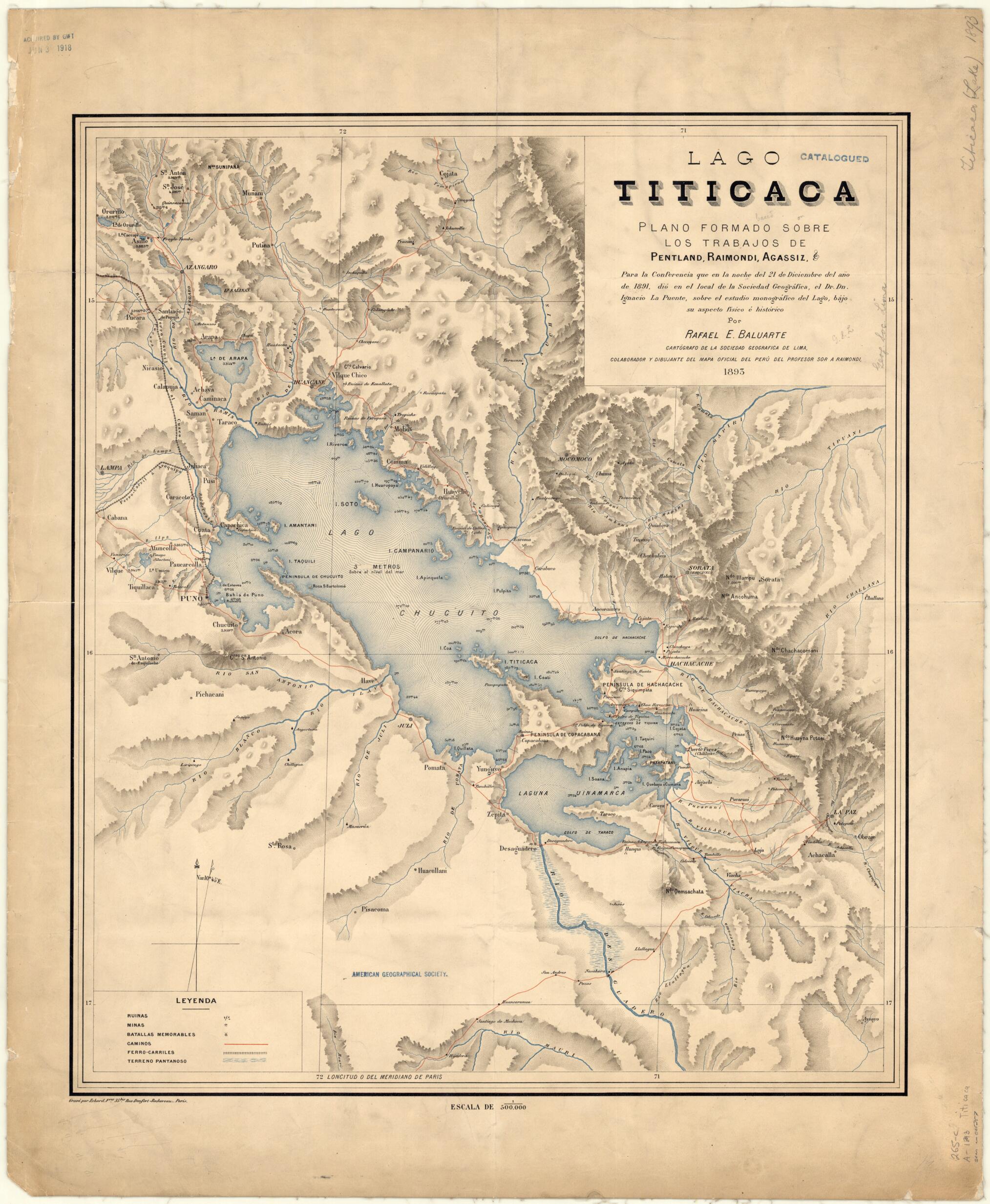
Old map of Bolivia, Peru.-1873), the Italian-Peruvian geographer and naturalist Antonio Raimondi (1826--90), the Swiss-born naturalist Louis Agassiz (1807--73), and others. The map shows ancient ruins, mines, the sites of noteworthy battles, roads, and railroads. Depths in the lake are indicated in meters. Relief is shown by hachures. The prime meridian is Paris, where the map was engraved. Located partly in Peru and partly in Bolivia, Titicaca is the largest freshwater lake in South America. At 3,810 meters above sea level, it is the highest of the world's large lakes. It covers 8,300 square kilometers, and extends in a northwest-to-southeast direction for a distance of 190 kilometers. At its widest point the lake is 80 kilometers across. The lake averages between 140 and 180 meters in depth, and reaches its greatest recorded depth of 280 meters off Isla Soto in its northeastern corner. (This map shows a depth of 256.49 meters at a location just east of the island.) More than 25 rivers flow into Lake Titicaca. Archeological ruins and other evidence indicate that different peoples have lived around the lake continuously since as early as 10,000 BC. These peoples have included the Pukara, Tiwanaku, Colla Lupaka, and Inca.
Created by Rafael E. Baluarte, Erhard (Firm), D. Ignacio La Puente in 1893.
- Title devised, in English, by Library staff.
- "Scale 1:500,000"--Note extracted from World Digital Library.
- Original resource extent: 1 map : color ; 59 x 50 centimeters.
- Original resource at: University of Wisconsin-Milwaukee Libraries.
- Content in Spanish.
- Description based on data extracted from World Digital Library, which may be extracted from partner institutions.
- For the best legibility, order your map in the original size or larger. Most maps have intricate detail and small text that is best appreciated when the print size hasn't been reduced.
- Sizes labeled "Fits a Standard Frame" will drop right into any frame that you purchase in that size. The sizes that we offer are commonly available online and at most retail stores.
- Our standard sizes are recommendations based on the aspect ratio of the original map, but still may require some added "white space" in one dimension to fit.
- Non-standard sizes will require custom framing, and we suggest taking your print to the frame shop of your choice after you receive it for the best results.
- Custom sizes are available, simply contact us for a quote.
Below is an approximation of the scale of a few standard sizes, and how they might appear in your space.

