
Map of the Colonies of Suriname and Berbice. (Landkaart Van De Volkplantingen Suriname En Berbice) 1700
- Regular price
-
$58.95 - Regular price
-
$53.95 - Sale price
-
$58.95
Buy one map, get any other map in our collection for 50% OFF! Add to cart to see discount.
Couldn't load pickup availability
About This Map
Discover the timeless beauty of our fine art quality printed reproduction of this antique map. Perfect for history enthusiasts, collectors, and interior decorators.
Restored with meticulous attention to detail by our team with over a decade of experience, this stunning reproduction captures the intricate artistry and historical significance of the original map.
Whether you're a collector or seeking a unique decor piece, this archival-quality map reproduction is a timeless addition to any space. Order now to bring history to life!
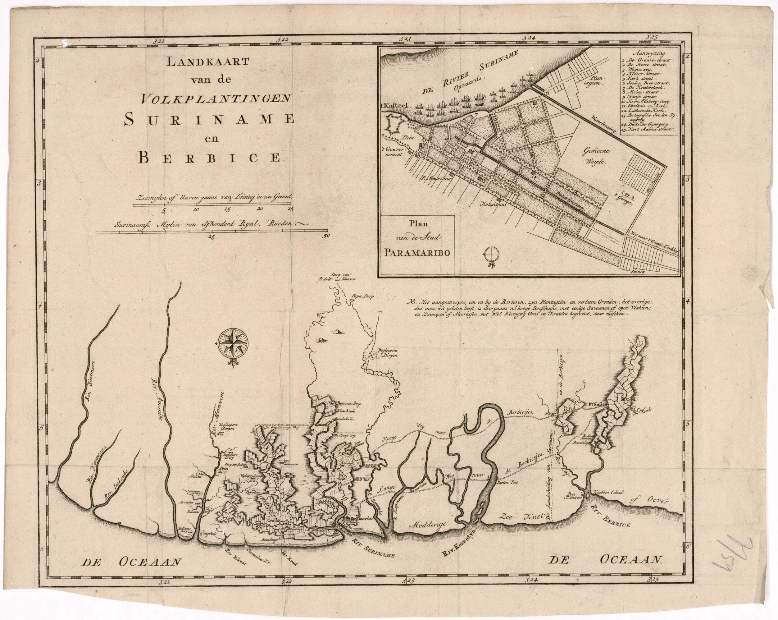
Old map of Guyana, Paramaribo, Suriname.century map shows the Dutch plantations in Suriname and Berbice. The map is oriented with the north at the bottom. The names ascribed to locations outside the neatly demarcated plantations suggest resistance to Dutch domination by local Indians, indentured servants, and slaves imported from Africa. They include several places marked "rebel villages," "village of runaways," and "village of rebel slaves." The inset map in the upper right gives a detailed view of Paramaribo, the chief city and port of Suriname. The numbered key lists the main streets, along with the locations of the city hall and main (Dutch Reformed) church, the Lutheran church, and Portuguese and German synagogues. Berbice, located along the Berbice River, was established in 1627 as a Dutch colony under the authority of the Dutch West India Company. In 1814, during the Napoleonic Wars, ownership of the colony passed to the British, who merged it with the neighboring colony of British Guiana. The country gained its independence as Guyana in 1966. Suriname, which bordered Berbice to the east, was seized by Dutch forces from England in 1667, during the Second Anglo-Dutch War (1665--67). It remained a Dutch possession until 1975, when it became an independent country.
- Title devised, in English, by Library staff.
- Original resource extent: 1 map ; 40 x 33 centimeters.
- Original resource at: Columbus Memorial Library, Organization of American States.
- Content in Dutch.
- Description based on data extracted from World Digital Library, which may be extracted from partner institutions.
- For the best legibility, order your map in the original size or larger. Most maps have intricate detail and small text that is best appreciated when the print size hasn't been reduced.
- Sizes labeled "Fits a Standard Frame" will drop right into any frame that you purchase in that size. The sizes that we offer are commonly available online and at most retail stores.
- Our standard sizes are recommendations based on the aspect ratio of the original map, but still may require some added "white space" in one dimension to fit.
- Non-standard sizes will require custom framing, and we suggest taking your print to the frame shop of your choice after you receive it for the best results.
- Custom sizes are available, simply contact us for a quote.
Below is an approximation of the scale of a few standard sizes, and how they might appear in your space.

