
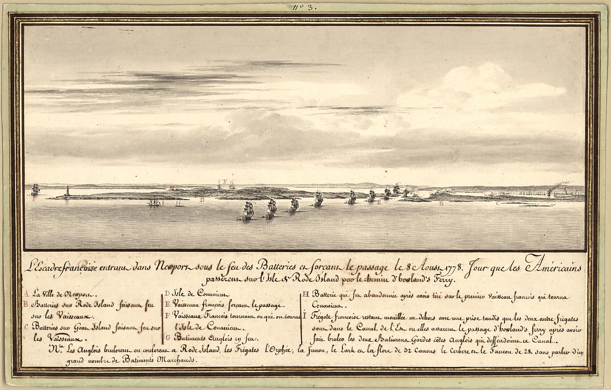
L'escadre Françoise Entrant Dans Newport Sous Le Feu Des Batteries Et Forcant Le Passage Le 8 Aoust 1778 : Jour Que Les Américains Passerent Sur L'Isle De Rode Island Par Le Chemin D'howland's Ferry
- Regular price
-
$51.95 - Regular price
-
$35.95 - Sale price
-
$51.95
Buy one map, get any other map in our collection for 50% OFF! Add to cart to see discount.
Couldn't load pickup availability
About This Map
Discover the timeless beauty of our fine art quality printed reproduction of this antique map. Perfect for history enthusiasts, collectors, and interior decorators.
Restored with meticulous attention to detail by our team with over a decade of experience, this stunning reproduction captures the intricate artistry and historical significance of the original map.
Whether you're a collector or seeking a unique decor piece, this archival-quality map reproduction is a timeless addition to any space. Order now to bring history to life!
Old early map / manuscript map / aerial view of Island, Newport Region, Rhode Island, United States.Created by Pierre Ozanne in 1778.
- Relief shown pictorially.
- Oriented with north to the left.
- Pen-and-ink, watercolor, and gilt.
- Includes index to defenses and points of interest.
- Note at bottom: Nta. les anglois brulereus ou coulereus a Rode Island, les frigates l'Orphée, le Lark en la flore de 32 canons, le Cerbere en le Faucon de 28 sans parler d'un grand nombre de batiments Marchands.
- This map has some imperfections: mostly indecipherable pencil annotation on verso. We'll do our best to restore the image before printing.
Map Subjects
Aerial Views
Defenses
Early Maps
Early Works To 1800
Manuscript Maps
Newport Region
Newport Region (R.I.)
Rhode Island
Rhode Island (R.I. : Island)
Rhode Island Battle Of R.I.
United States
Island
Pierre Ozanne
1778
- For the best legibility, order your map in the original size or larger. Most maps have intricate detail and small text that is best appreciated when the print size hasn't been reduced.
- Sizes labeled "Fits a Standard Frame" will drop right into any frame that you purchase in that size. The sizes that we offer are commonly available online and at most retail stores.
- Our standard sizes are recommendations based on the aspect ratio of the original map, but still may require some added "white space" in one dimension to fit.
- Non-standard sizes will require custom framing, and we suggest taking your print to the frame shop of your choice after you receive it for the best results.
- Custom sizes are available, simply contact us for a quote.
Below is an approximation of the scale of a few standard sizes, and how they might appear in your space.
