

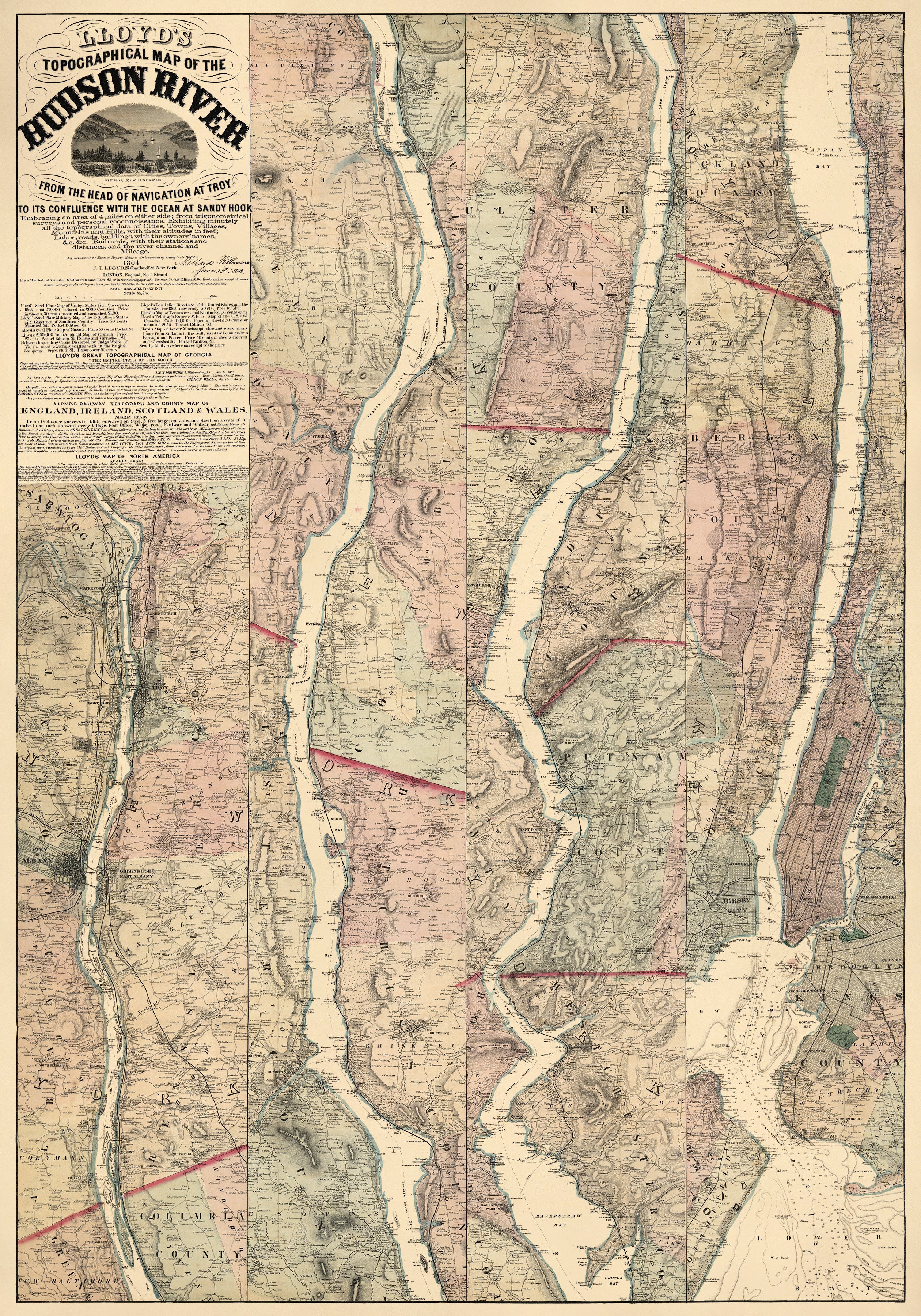
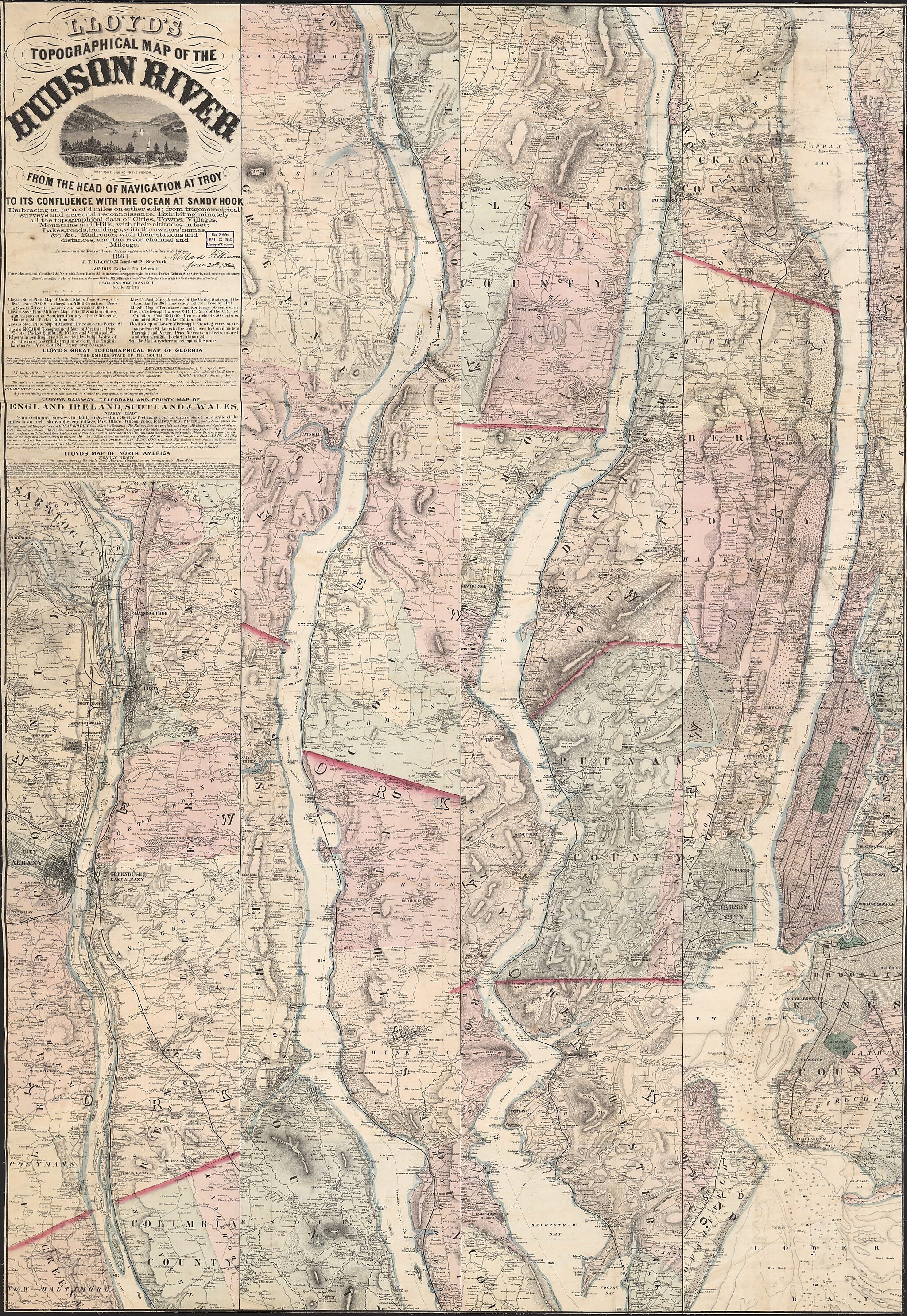
Lloyd's Topographical Map of the Hudson River : from the Head of Navigation at Troy to Its Confluence With the Ocean at Sandy Hook : Embracing an Area of 4 Miles On Either Side ... and the River Channel and Mileage. (Topographical Map of the Hudson Ri...
- Regular price
-
$172.95 - Regular price
-
$167.95 - Sale price
-
$172.95
Buy one map, get any other map in our collection for 50% OFF! Add to cart to see discount.
Couldn't load pickup availability
About This Map
Discover the timeless beauty of our fine art quality printed reproduction of this antique map. Perfect for history enthusiasts, collectors, and interior decorators.
Restored with meticulous attention to detail by our team with over a decade of experience, this stunning reproduction captures the intricate artistry and historical significance of the original map.
Whether you're a collector or seeking a unique decor piece, this archival-quality map reproduction is a timeless addition to any space. Order now to bring history to life!
Old topographic map of Hudson River, Hudson River Valley, New Jersey, New York, New York (State), New York Harbor, New York Metropolitan Area, United States.Created by Millard Fillmore, James T. Lloyd in 1864.
- In the rural land areas the map shows all buildings and householders' names.
- Relief shown by hachures; harbor depths shown by hachures and soundings.
- Hand colored to distinguish towns (townships), urban municipalities, and county boundaries.
- Signed in ink script in title area on recto: Millard Fillmore, June 20th 1864; on verso on cloth backing: Millard Fillmore, June 20, 1864; on large paper label affixed to verso: Millard Fillmore, June 26, 1864; on small paper label affixed to verso: Hudson River, 110. E--1864, Millard Fillmore, June 24 1864.
- "Entered, according to Act of Congress, in the year 1864 by J.L.Lloyd in the Clerk's Office of the Dis't Court of the U.S. for the Sth'n Dis't of New York."
- Printed in 4 side-by-side segments: [Northern] -- [North-central] -- [South-central] -- [Southern including New York city metro-area and New York Harbor].
- Includes text, notes, and advertisements for other Lloyd publications.
Map Subjects
Administrative And Political Divisions
Harbors
Hudson River
Hudson River (N.Y. And N.J.)
Hudson River Valley
Hudson River Valley (N.Y. And N.J.)
Landowners
New Jersey
New York (State)
New York Harbor (N.Y. And N.J.)
New York Metropolitan Area
Topographic Maps
United States
New York
New York Harbor
Millard Fillmore
James T. Lloyd
1864
- For the best legibility, order your map in the original size or larger. Most maps have intricate detail and small text that is best appreciated when the print size hasn't been reduced.
- Sizes labeled "Fits a Standard Frame" will drop right into any frame that you purchase in that size. The sizes that we offer are commonly available online and at most retail stores.
- Our standard sizes are recommendations based on the aspect ratio of the original map, but still may require some added "white space" in one dimension to fit.
- Non-standard sizes will require custom framing, and we suggest taking your print to the frame shop of your choice after you receive it for the best results.
- Custom sizes are available, simply contact us for a quote.
Below is an approximation of the scale of a few standard sizes, and how they might appear in your space.

