
Luxemburg, Eine Vortressliche Festung Des Herzogth. Gleiches Nahmens In Niederl in 1730
- Regular price
-
$59.95 - Regular price
-
$54.95 - Sale price
-
$59.95
Buy one map, get any other map in our collection for 50% OFF! Add to cart to see discount.
Couldn't load pickup availability
About This Map
Discover the timeless beauty of our fine art quality printed reproduction of this antique map. Perfect for history enthusiasts, collectors, and interior decorators.
Restored with meticulous attention to detail by our team with over a decade of experience, this stunning reproduction captures the intricate artistry and historical significance of the original map.
Whether you're a collector or seeking a unique decor piece, this archival-quality map reproduction is a timeless addition to any space. Order now to bring history to life!
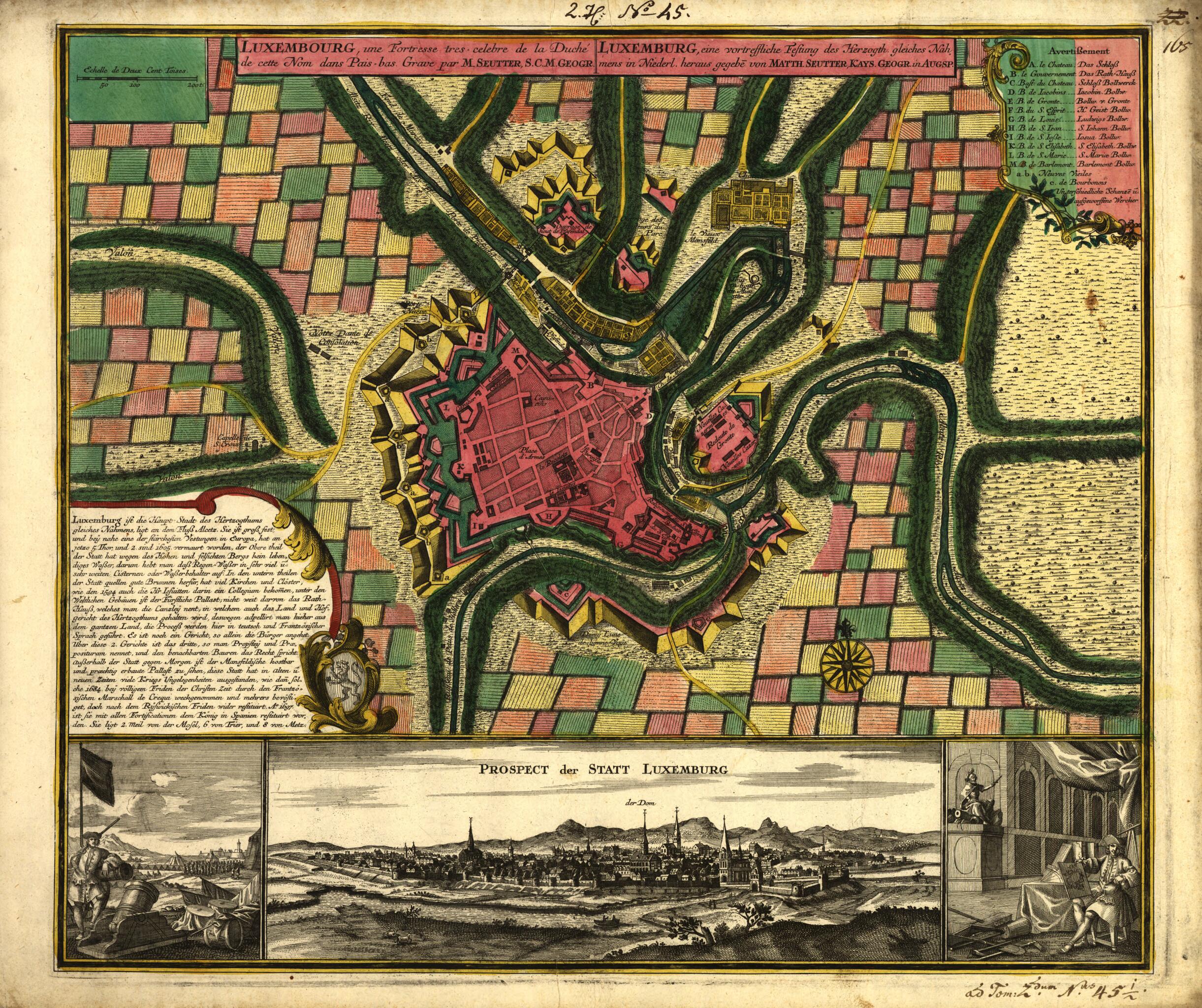
Old map of Luxembourg.1756), shows both the fortifications and, in the inset at the bottom, a pictorial view of the city. Seutter was an engraver, map publisher, and globe maker from Augsburg, Germany. He was apprenticed to the Nuremberg map publisher Johann Baptist Homann in 1697, but returned to Augsburg around 1707 to set up his own firm. In 1731, Emperor Karl VI awarded him the title of Imperial Geographer. This map is from Seutter's Grosser Atlas worinnen enthalten alle die jenige geographisches Universal-Special- und Particular-Mappen, mit über die mehresten gedrukten alphabetischen Registern (Large atlas, wherein are contained all the recent geographic universal, special, and particular maps, with the largest number of published alphabetical registers), published in 1734." World Digital Library.
Created by Matthaeus Seutter in 1730.
- Annotated in ink in upper margin: 2.H. No. 45; and in lower margin: ad Tom. 2'dum N'us 45i/s.
- Appears in Seutter's Grosser Atlas worinnen enthalten alle die jenige geographisches Universal-Special- und Particular-Mappen, mit über die mehresten gedrukten alphabetischen Registern, 1734.
- Includes text, index to points of interest, inset panoramic "Prospect der Statt Luxemburg" at bottom, bar "Echelle de deux cent toises", ill., and coat-of-arms.
- Relief shown by hachures.
- Title and index in French and German; text in German.
- For the best legibility, order your map in the original size or larger. Most maps have intricate detail and small text that is best appreciated when the print size hasn't been reduced.
- Sizes labeled "Fits a Standard Frame" will drop right into any frame that you purchase in that size. The sizes that we offer are commonly available online and at most retail stores.
- Our standard sizes are recommendations based on the aspect ratio of the original map, but still may require some added "white space" in one dimension to fit.
- Non-standard sizes will require custom framing, and we suggest taking your print to the frame shop of your choice after you receive it for the best results.
- Custom sizes are available, simply contact us for a quote.
Below is an approximation of the scale of a few standard sizes, and how they might appear in your space.

