
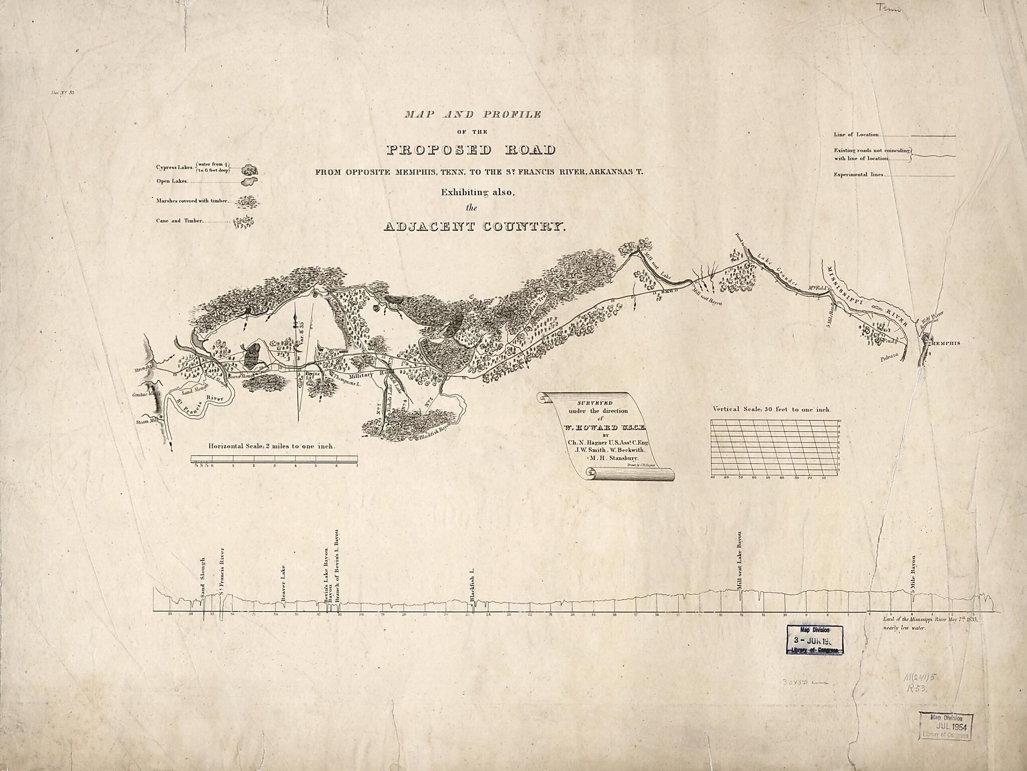
Map and Profile of the Proposed Road from Opposite Memphis, Tennessee to the St. Francis River, Arkansas T. : Exhibiting Also, the Adjacent Country 1833
- Regular price
-
$80.95 - Regular price
-
$75.95 - Sale price
-
$80.95
Buy one map, get any other map in our collection for 50% OFF! Add to cart to see discount.
Couldn't load pickup availability
About This Map
Discover the timeless beauty of our fine art quality printed reproduction of this antique map. Perfect for history enthusiasts, collectors, and interior decorators.
Restored with meticulous attention to detail by our team with over a decade of experience, this stunning reproduction captures the intricate artistry and historical significance of the original map.
Whether you're a collector or seeking a unique decor piece, this archival-quality map reproduction is a timeless addition to any space. Order now to bring history to life!
Old map of Arkansas, Missouri, Saint Francis River, United States.Created by W. Beckwith, Charles N. Hagner, W. (William) Howard, John W. A. Smith, M. H. Stansbury, United States. Army. Corps of Engineers in 1833.
- Relief shown in hachures.
- "Level of the Mississippi River May 7th, 1833, nearly low water."
- From map in U.S. House Doc. no. 83, 23rd Congress, 2nd Session, 1834-1835, vol. 3.
- The route is shown by line symbol with "Military Road" alongside. An "Indian Track" is indicated. Legend contains symbols for cypress and open lakes, marshes covered with timber, can and timber.
- Includes inset of profile with vertical scale of 1:360.
Map Subjects
Arkansas
Roads
Saint Francis River
Saint Francis River (Mo. And Ark.)
United States
Missouri
W. Beckwith
Charles N. Hagner
W. (William) Howard
John W. A. Smith
M. H. Stansbury
United States. Army. Corps Of Engineers
1833
- For the best legibility, order your map in the original size or larger. Most maps have intricate detail and small text that is best appreciated when the print size hasn't been reduced.
- Sizes labeled "Fits a Standard Frame" will drop right into any frame that you purchase in that size. The sizes that we offer are commonly available online and at most retail stores.
- Our standard sizes are recommendations based on the aspect ratio of the original map, but still may require some added "white space" in one dimension to fit.
- Non-standard sizes will require custom framing, and we suggest taking your print to the frame shop of your choice after you receive it for the best results.
- Custom sizes are available, simply contact us for a quote.
Below is an approximation of the scale of a few standard sizes, and how they might appear in your space.

