
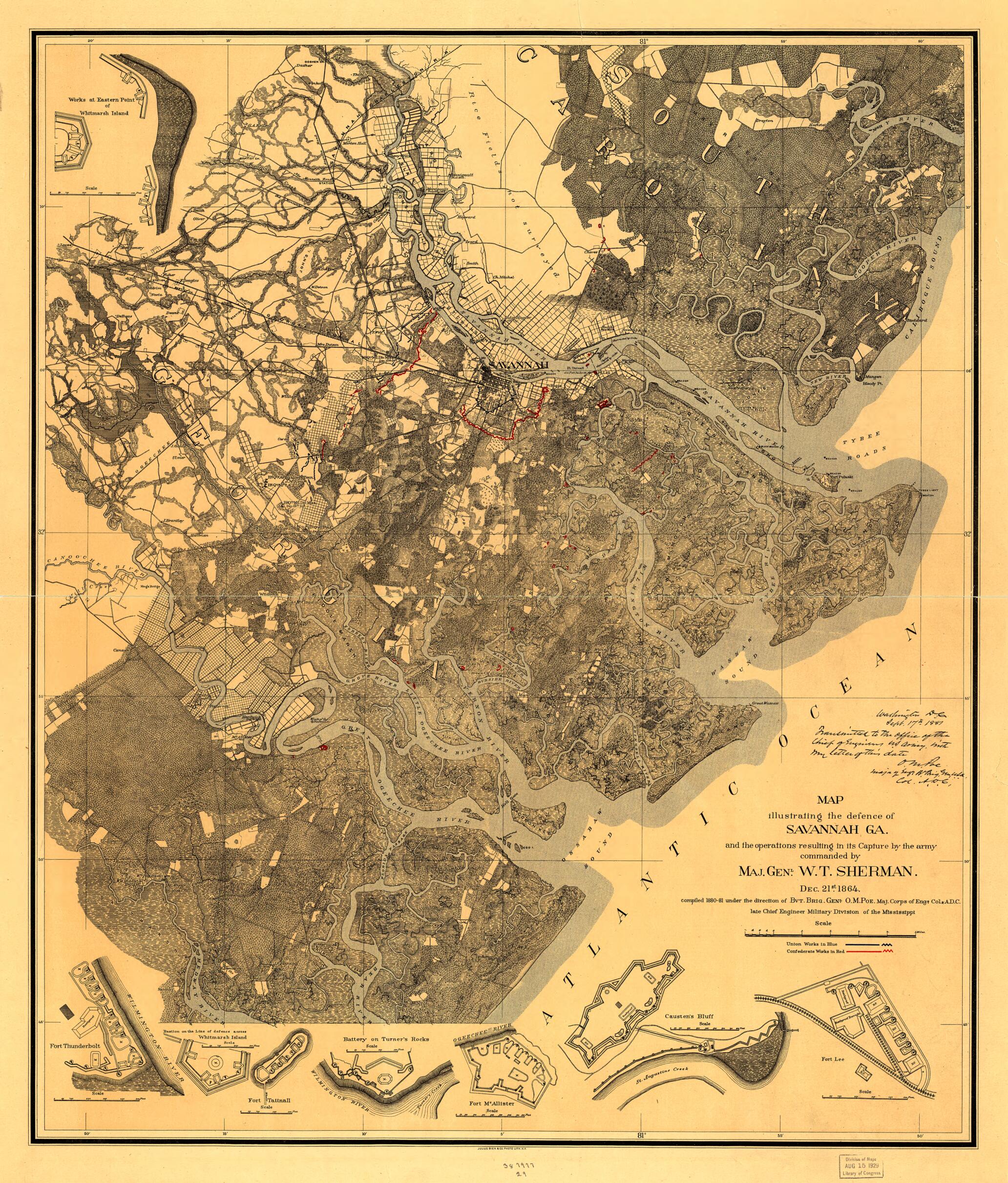
Map Illustrating the Defence of Savannah, Georgia and the Operations Resulting In Its Capture by the Army Commanded by Maj. Genl. W. T. Sherman. Dec. 21st 1864 in 1881
- Regular price
-
$86.95 - Regular price
-
$81.95 - Sale price
-
$86.95
Buy one map, get any other map in our collection for 50% OFF! Add to cart to see discount.
Couldn't load pickup availability
About This Map
Discover the timeless beauty of our fine art quality printed reproduction of this antique map. Perfect for history enthusiasts, collectors, and interior decorators.
Restored with meticulous attention to detail by our team with over a decade of experience, this stunning reproduction captures the intricate artistry and historical significance of the original map.
Whether you're a collector or seeking a unique decor piece, this archival-quality map reproduction is a timeless addition to any space. Order now to bring history to life!
Old map of Georgia, Savannah, United States.Created by O. M. (Orlando Metcalfe) Poe in 1881.
- Scale ca. 1:85,000.
- Civil War Map
- The following inscription in the author's handwriting is reproduced above the title: Washington, D.C., Sept 17th 1881. Transmitted to the office of the Chief of Engineers, U.S. Army, with my letter of this date. [Signed] O. M. Poe, Major of Engrs., B. Brig. Gen., U.S.A., Col. A.D.C.
- Detailed map of Savannah and vicinity, showing "Union works in blue," "Confederate works in red," roads, railroads, vegetation, drainage, houses, names of a few residents in outlying areas, fences, and geographic coordinates.
- Includes plans of the following fortifications: Works at eastern point of Whitmarsh Island; Fort Thunderbolt; Bastion on the line of defence across Whitmarsh Island; Fort Tattnall; Battery on Turner's Rocks; Fort McAllister; Causten's Bluff; and Fort Lee.
- Description derived from published bibliography.
- For the best legibility, order your map in the original size or larger. Most maps have intricate detail and small text that is best appreciated when the print size hasn't been reduced.
- Sizes labeled "Fits a Standard Frame" will drop right into any frame that you purchase in that size. The sizes that we offer are commonly available online and at most retail stores.
- Our standard sizes are recommendations based on the aspect ratio of the original map, but still may require some added "white space" in one dimension to fit.
- Non-standard sizes will require custom framing, and we suggest taking your print to the frame shop of your choice after you receive it for the best results.
- Custom sizes are available, simply contact us for a quote.
Below is an approximation of the scale of a few standard sizes, and how they might appear in your space.

