
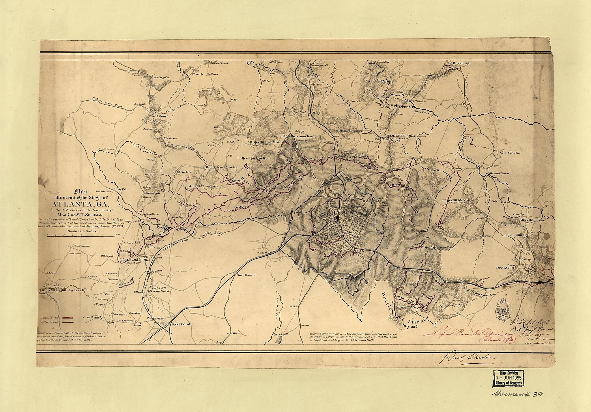
Map Illustrating the Siege of Atlanta, Georgia, by the U.S. Forces Under Command of Maj. Gen. W.T. Sherman, from the Passage of Peach Tree Creek, July 19th 1864, to the Commencement of the Movement Upon the Enemy's Lines of Communication South of Atla...
- Regular price
-
$57.95 - Regular price
-
$40.95 - Sale price
-
$57.95
Buy one map, get any other map in our collection for 50% OFF! Add to cart to see discount.
Couldn't load pickup availability
About This Map
Discover the timeless beauty of our fine art quality printed reproduction of this antique map. Perfect for history enthusiasts, collectors, and interior decorators.
Restored with meticulous attention to detail by our team with over a decade of experience, this stunning reproduction captures the intricate artistry and historical significance of the original map.
Whether you're a collector or seeking a unique decor piece, this archival-quality map reproduction is a timeless addition to any space. Order now to bring history to life!
Old map of Atlanta, Atlanta Metropolitan Area, Georgia, United States.Created by Richard Delafield, E. Molitor, O. M. (Orlando Metcalfe) Poe, William T. (William Tecumseh) Sherman, United States. War Department in 1864.
- Partial cadastral map showing selected buildings and householders' names beyond city limits.
- Covers area extending from Mt. Gilead Church in west to Decatur in east and from Buckhead in north to East Point in south.
- Relief shown by hachures and spot heights.
- Shows troop positions, Union and Confederate works, roads, railroads, vegetation, drainage, and names, dates, and sites of battles connected with Atlanta Campaign.
- "Note. The red figures indicate elevation at these points above the plan [sic] of reference, which is taken at 50 ft. below the water-table of the City Hall."
- Civil War Map
- Annotated in red ink at lower right: Engineer Bureau, War Department, December 28/'65.
- Annotated in black ink at lower right: Richd. Delafield, Bvt. Major General Chief Engineer.
- Annotated in black ink in lower right margin: Proof sheet.
- This map has some imperfections: soiled, stained, mounted on paper backing, portions of left and right sides of map cut off. We'll do our best to restore the image before printing.
Map Subjects
Atlanta
Atlanta Campaign
Atlanta Metropolitan Area
Georgia
Landowners
United States
Richard Delafield
E. Molitor
O. M. (Orlando Metcalfe) Poe
William T. (William Tecumseh) Sherman
United States. War Department
1864
- For the best legibility, order your map in the original size or larger. Most maps have intricate detail and small text that is best appreciated when the print size hasn't been reduced.
- Sizes labeled "Fits a Standard Frame" will drop right into any frame that you purchase in that size. The sizes that we offer are commonly available online and at most retail stores.
- Our standard sizes are recommendations based on the aspect ratio of the original map, but still may require some added "white space" in one dimension to fit.
- Non-standard sizes will require custom framing, and we suggest taking your print to the frame shop of your choice after you receive it for the best results.
- Custom sizes are available, simply contact us for a quote.
Below is an approximation of the scale of a few standard sizes, and how they might appear in your space.
