
Map of Alexandria, Virginia 1861
- Regular price
-
$49.95 - Regular price
-
$29.95 - Sale price
-
$49.95
Buy one map, get any other map in our collection for 50% OFF! Add to cart to see discount.
Couldn't load pickup availability
About This Map
Discover the timeless beauty of our fine art quality printed reproduction of this antique map. Perfect for history enthusiasts, collectors, and interior decorators.
Restored with meticulous attention to detail by our team with over a decade of experience, this stunning reproduction captures the intricate artistry and historical significance of the original map.
Whether you're a collector or seeking a unique decor piece, this archival-quality map reproduction is a timeless addition to any space. Order now to bring history to life!
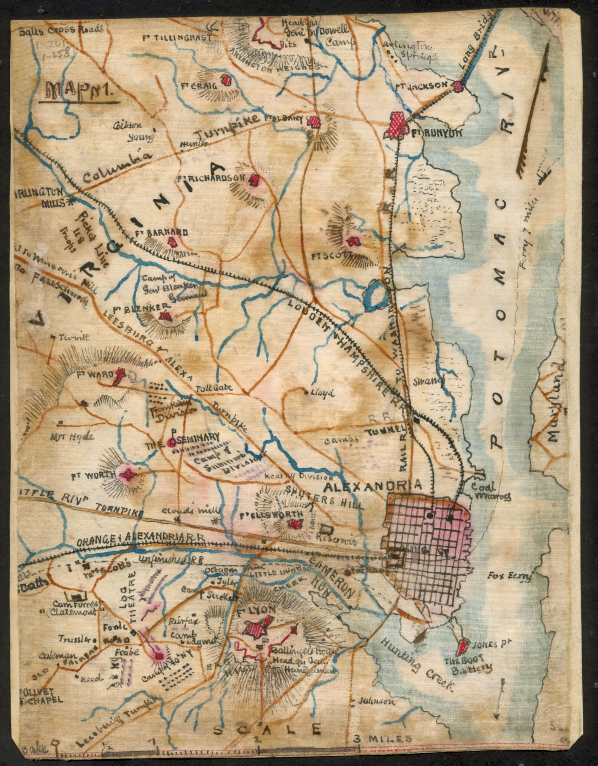
Old map of Alexandria, District of Columbia, Fort Lyon, United States, Virginia, Washington, Washington D.C..Illustrates Alexandria's central position in the defense of Washington, where at least 12 outlying forts surrounded the city. Military camps of various Union officers such as Samuel Peter Heintzelman are indicated on this map.
Created by Robert Knox Sneden in 1861.
- Samuel Peter Heintzelman, whom Sneden served under, was headquartered at Fort Lyon, southwest of Alexandria. Heintzelman was in charge of the defense of Washington from 27 October 1862-13 October 1863.
- This item is from the collections of the Virginia Historical Society; please contact the institution for more information.
- Robert Knox Sneden scrapbook (Mss5:7 Sn237:1), Virginia Historical Society.
- In the Robert Knox Sneden diary, 1861-1865 (v. 1, p. 261).
- Manuscripts
- For the best legibility, order your map in the original size or larger. Most maps have intricate detail and small text that is best appreciated when the print size hasn't been reduced.
- Sizes labeled "Fits a Standard Frame" will drop right into any frame that you purchase in that size. The sizes that we offer are commonly available online and at most retail stores.
- Our standard sizes are recommendations based on the aspect ratio of the original map, but still may require some added "white space" in one dimension to fit.
- Non-standard sizes will require custom framing, and we suggest taking your print to the frame shop of your choice after you receive it for the best results.
- Custom sizes are available, simply contact us for a quote.
Below is an approximation of the scale of a few standard sizes, and how they might appear in your space.

