
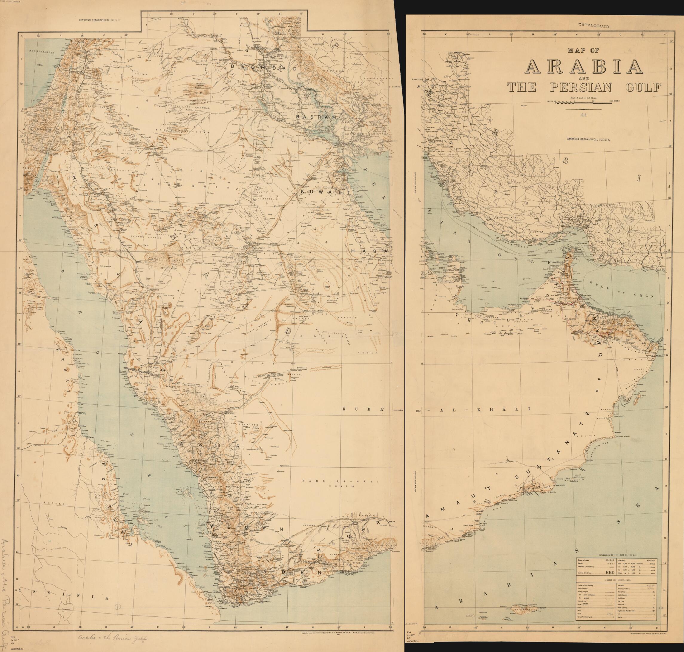
Map of Arabia and the Persian Gulf 1917
- Regular price
-
$143.95 - Regular price
-
$138.95 - Sale price
-
$143.95
Buy one map, get any other map in our collection for 50% OFF! Add to cart to see discount.
Couldn't load pickup availability
About This Map
Discover the timeless beauty of our fine art quality printed reproduction of this antique map. Perfect for history enthusiasts, collectors, and interior decorators.
Restored with meticulous attention to detail by our team with over a decade of experience, this stunning reproduction captures the intricate artistry and historical significance of the original map.
Whether you're a collector or seeking a unique decor piece, this archival-quality map reproduction is a timeless addition to any space. Order now to bring history to life!
Old map of Bahrain, Iran, Islamic Republic of, Israel, Jordan, Oman, Qatar, Saudi Arabia, United Arab Emirates, Yemen.This map of the Arabian Peninsula and the Persian Gulf emphasizes the physical terrain and transportation routes as surveyed in 1916 by the Survey of India, the cartographic branch of the British government of India. It was prepared at the beginning of the British campaign against the Ottoman Empire during the First World War. The map provided a general view of the Middle East Theater and was not intended for any particular army operation. It shows the Hejaz Railway, undersea telegraph cables, pilgrimage routes, and the location of oil installations in southwestern Iran. International boundaries are absent from the map. It does show Babylon and the Sasanian ruins at Ctesiphon near Baghdad, two famous sites of archeological interest. The map key on the second of the two sheets explains the abbreviations and symbols used. Relief is shown by hachures and spot elevations. The Survey of India was established in 1767 to assist the British East India Company, and later the British government, in administering its south Asian empire. The map was published in 1917 under the direction of Colonel Sir Sidney Burrard, surveyor general of India. The printing technique was heliozincography, a photographic process using zinc plates that was developed in Britain and that enabled accurate reproduction of images and text. It was printed at the Survey's factory in Dehra Dun, India.
Created by Sidney Gerald Burrard, Survey of India in 1917.
- Title devised, in English, by Library staff.
- "Scale: 1 inch = 48 miles."--Note extracted from World Digital Library.
- Original resource extent: 1 map on 2 sheets : color ; sheets 88 x 39 centimeters and 93 x 58 centimeters.
- Original resource at: University of Wisconsin-Milwaukee Libraries.
- Content in English.
- Description based on data extracted from World Digital Library, which may be extracted from partner institutions.
- For the best legibility, order your map in the original size or larger. Most maps have intricate detail and small text that is best appreciated when the print size hasn't been reduced.
- Sizes labeled "Fits a Standard Frame" will drop right into any frame that you purchase in that size. The sizes that we offer are commonly available online and at most retail stores.
- Our standard sizes are recommendations based on the aspect ratio of the original map, but still may require some added "white space" in one dimension to fit.
- Non-standard sizes will require custom framing, and we suggest taking your print to the frame shop of your choice after you receive it for the best results.
- Custom sizes are available, simply contact us for a quote.
Below is an approximation of the scale of a few standard sizes, and how they might appear in your space.

