
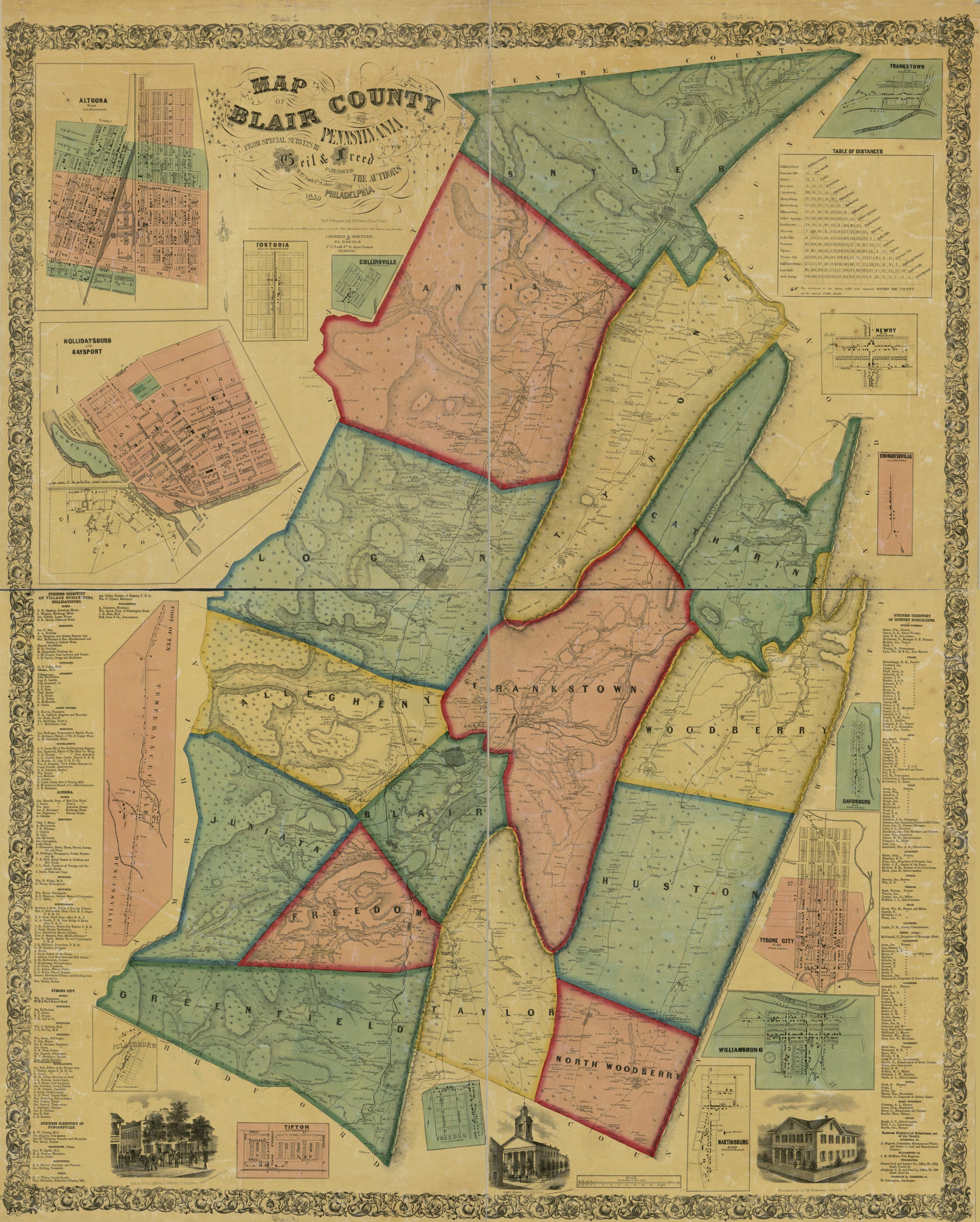
Map of Blair County, Pennsylvania : From Special Surveys in 1859
- Regular price
-
$217.95 - Regular price
-
$212.95 - Sale price
-
$217.95
Buy one map, get any other map in our collection for 50% OFF! Add to cart to see discount.
Couldn't load pickup availability
About This Map
Discover the timeless beauty of our fine art quality printed reproduction of this antique map. Perfect for history enthusiasts, collectors, and interior decorators.
Restored with meticulous attention to detail by our team with over a decade of experience, this stunning reproduction captures the intricate artistry and historical significance of the original map.
Whether you're a collector or seeking a unique decor piece, this archival-quality map reproduction is a timeless addition to any space. Order now to bring history to life!
Old cadastral map of Altoona, Blair County, Hollidaysburg, Pennsylvania, Tyrone, United States.Created by Rufus L. Barnes, Isaac G. Freed, Geil & Freed, Thos. S. Wagner's Lith in 1859.
- General-content county map also showing buildings in rural areas, householders' names, and forested areas; real-property tracts, lot numbers, and building coverage also are shown in all the town/village insets (but esp. for Altoona, Hollidaysburg, and Tyrone).
- Relief shown by hachures.
- Hand col. to emphasize township boundaries and territories.
- At foot of statement of attribution: Published by the authors.
- "Entered according to act of Congress in the year 1859 by Isaac G. Freed in the ... Eastern District of Penn'a."
- Originally printed on 4 sheets.
- This map has some imperfections: shellacked, halved to enable folding, trimmed, north sheet annotated in brown ink on cloth backing: no. 129. deposited july 7th 18[2 ciphers trimmed off] isaac g. freed; copy 2 not shellacked, not annotated, missing small sections along fold lines. We'll do our best to restore the image before printing.
- Includes business directories, table of road distances, and ill. of principal buildings.
- Town and village insets: Altoona -- Hollidaysburg and Gaysport -- Fostoria -- Collinsville -- Frankstown -- Newry -- Charlotteville -- Davidsburg -- Tyrone City -- Williamsburg -- Martinsburg -- Freedom -- Tipton -- Claysburg -- Foot of Ten, Temperanceville, Duncansville.
- Land Ownership Map
- 3 copies
- For the best legibility, order your map in the original size or larger. Most maps have intricate detail and small text that is best appreciated when the print size hasn't been reduced.
- Sizes labeled "Fits a Standard Frame" will drop right into any frame that you purchase in that size. The sizes that we offer are commonly available online and at most retail stores.
- Our standard sizes are recommendations based on the aspect ratio of the original map, but still may require some added "white space" in one dimension to fit.
- Non-standard sizes will require custom framing, and we suggest taking your print to the frame shop of your choice after you receive it for the best results.
- Custom sizes are available, simply contact us for a quote.
Below is an approximation of the scale of a few standard sizes, and how they might appear in your space.

