
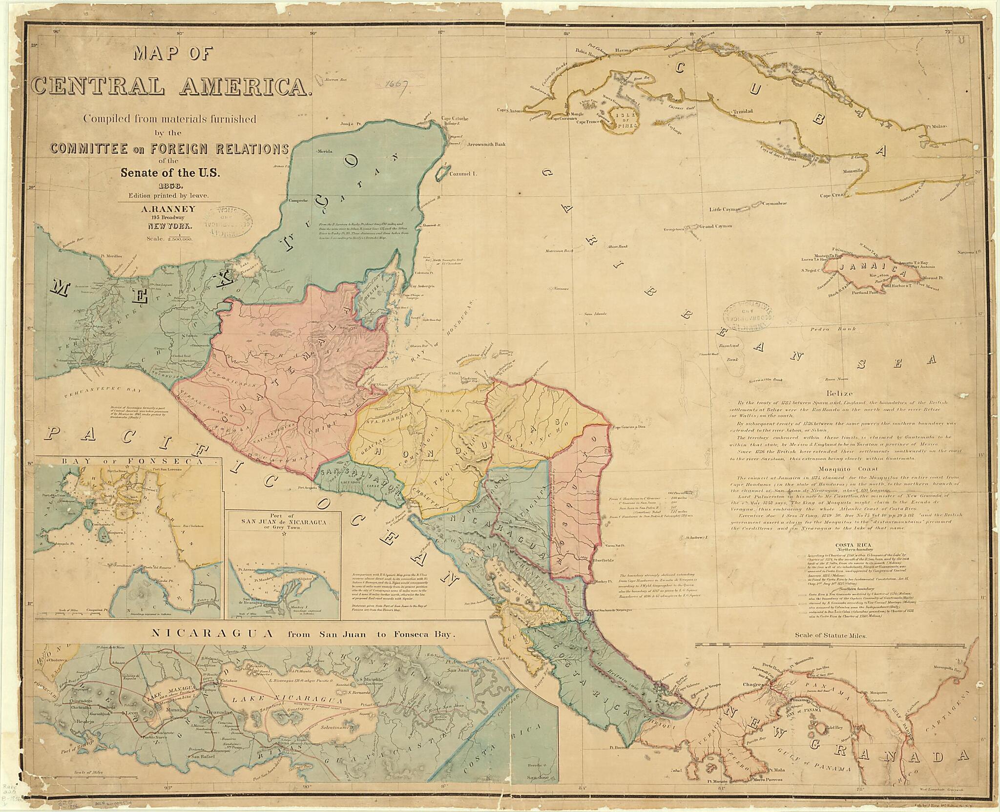
Map of Central America, 1856. (Map of Central America)
- Regular price
-
$118.95 - Regular price
-
$113.95 - Sale price
-
$118.95
Buy one map, get any other map in our collection for 50% OFF! Add to cart to see discount.
Couldn't load pickup availability
About This Map
Discover the timeless beauty of our fine art quality printed reproduction of this antique map. Perfect for history enthusiasts, collectors, and interior decorators.
Restored with meticulous attention to detail by our team with over a decade of experience, this stunning reproduction captures the intricate artistry and historical significance of the original map.
Whether you're a collector or seeking a unique decor piece, this archival-quality map reproduction is a timeless addition to any space. Order now to bring history to life!
Old map of Belize, Costa Rica, Cuba, El Salvador, Guatemala, Honduras, Jamaica, Mexico, Nicaragua, Panama.74). It shows the extreme southern part of Mexico and the six countries of Central America: Guatemala, Honduras, San Salvador (El Salvador), Nicaragua, Costa Rica, and the Mosquito Coast (later British Honduras, today Belize). Panama is still part of Colombia, which at this time is called New Granada. Relief is shown by hachures, contours, and spot elevations in feet. Depths are shown by soundings in feet. Three inset maps at the lower left show the Bay of Fonseca, the Port of San Juan de Nicaragua, and the southern part of Nicaragua from San Juan to the Bay of Fonseca, i.e., from the Atlantic to the Pacific coasts. The main line of the proposed canal route, running through Lake Nicaragua, is marked on the latter map. In the 1850s, Nicaragua was thought to be the most likely route of an isthmian canal, with Panama not yet seriously considered. Notes on the main map provide information about distances and geographic features, information found on other maps, and competing territorial claims and the status of various boundaries in the region. Under the Clayton-Bulwer Treaty, signed by Great Britain and the United States in April 1850, the two powers agreed not to seek exclusive control of the proposed isthmian canal or territory on either side of such a canal, not to fortify any position in the canal area, and not to establish colonies in Central America. The Mosquito Coast, where the British already had settlements, was an exception. The scale of the map is in statute miles.
Created by Julius Bien and Company, Adolphus Ranney, United States Coast and Geodetic Survey, United States. Congress. Senate. Committee on Foreign Relations in 1856.
- Title devised, in English, by Library staff.
- "Scale 1:2,500,000"--Note extracted from World Digital Library.
- Original resource extent: 1 map : color ; 73 x 93 centimeters.
- Original resource at: University of Wisconsin-Milwaukee Libraries.
- Content in English.
- Description based on data extracted from World Digital Library, which may be extracted from partner institutions.
Map Subjects
Administrative And Political Divisions
Belize
Boundaries
Costa Rica
Cuba
El Salvador
Expeditions And Surveys
Guatemala
Honduras
Jamaica
Mexico
Nicaragua
Panama
Topographic Maps
Treaties
Julius Bien And Company
Adolphus Ranney
United States Coast And Geodetic Survey
United States. Congress. Senate. Committee On Foreign Relations
1856
- For the best legibility, order your map in the original size or larger. Most maps have intricate detail and small text that is best appreciated when the print size hasn't been reduced.
- Sizes labeled "Fits a Standard Frame" will drop right into any frame that you purchase in that size. The sizes that we offer are commonly available online and at most retail stores.
- Our standard sizes are recommendations based on the aspect ratio of the original map, but still may require some added "white space" in one dimension to fit.
- Non-standard sizes will require custom framing, and we suggest taking your print to the frame shop of your choice after you receive it for the best results.
- Custom sizes are available, simply contact us for a quote.
Below is an approximation of the scale of a few standard sizes, and how they might appear in your space.

