
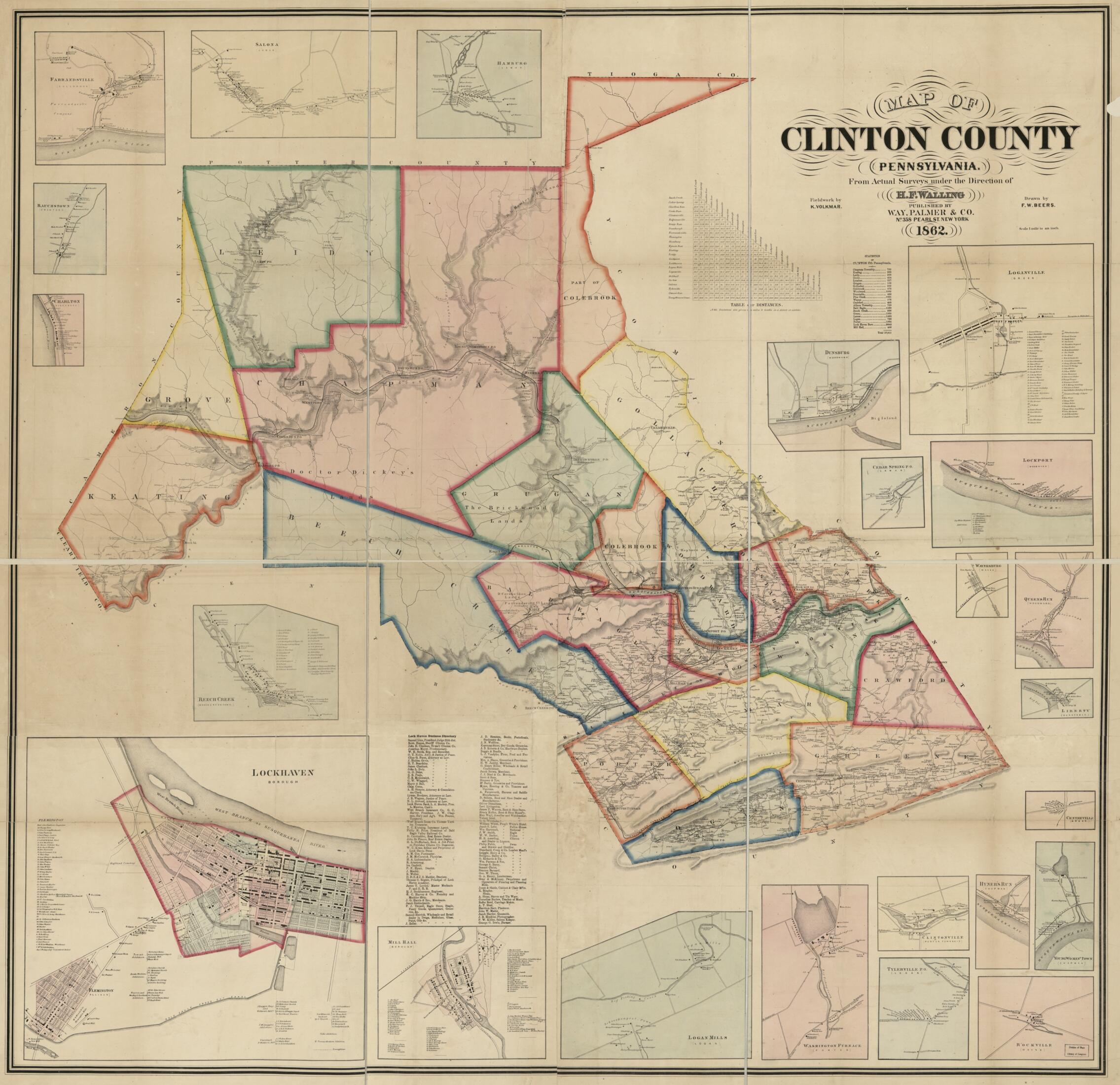
Map of Clinton County, Pennsylvania : From Actual Surveys in 1862
- Regular price
-
$202.95 - Regular price
-
$197.95 - Sale price
-
$202.95
Buy one map, get any other map in our collection for 50% OFF! Add to cart to see discount.
Couldn't load pickup availability
About This Map
Discover the timeless beauty of our fine art quality printed reproduction of this antique map. Perfect for history enthusiasts, collectors, and interior decorators.
Restored with meticulous attention to detail by our team with over a decade of experience, this stunning reproduction captures the intricate artistry and historical significance of the original map.
Whether you're a collector or seeking a unique decor piece, this archival-quality map reproduction is a timeless addition to any space. Order now to bring history to life!
Old cadastral map of Clinton County, Lock Haven, Mill Hall, Pennsylvania, United States.Created by F. W. (Frederick W.) Beers, K. Volkmar, Henry Francis Walling, Palmer & Co Way in 1862.
- General-content county map also showing rural buildings and householders' names; the Lock Haven and Mill Hall borough insets also show real-property tracts, landowners' names, and building coverage.
- Relief shown by hachures.
- Hand col. to emphasize township boundaries and territories.
- Printed in northern/southern segments (sheets).
- Originally printed on 4 sheets (later conjoined on cloth backing).
- This map has some imperfections: copy 1 sheets thirded to enable folding, fold-lined; copy 2 sheets shellacked, hemmed at edges. We'll do our best to restore the image before printing.
- Land Ownership Map
- Includes statistical table, strait-line distance table, Lock Haven business directory, and indexes of landowners' names for the Lock Haven and Mill Hall insets.
- Town and village insets (with township names as qualifiers): Lockhaven borough [sic] -- Mill Hall (borough) -- Beech Creek (Beech Creek Town.) -- Charlton (Pine Creek) -- Rauchstown (Crawford) -- Farrandsville (Colebrook) -- Salona (Lamar) -- Hamburg (Lamar) -- Loganville (Green) -- Dunsburg (Woodward) -- Cedar Spring P.O. (Lamar) -- Lockport (Woodward) -- Waynesburg (Wayne) -- Queens Run (Woodward) -- Liberty (Dunstable) -- Centreville (Green) -- YoungWomans Town [sic] (Chapman) -- Hyner's Run (Chapman) -- Rockville (Wayne) -- Tylerville P.O. (Logan) -- Clintonville (Porter Township) -- Washington Furnace (Porter) -- Logan Mills (Logan).
- 2 copies
- For the best legibility, order your map in the original size or larger. Most maps have intricate detail and small text that is best appreciated when the print size hasn't been reduced.
- Sizes labeled "Fits a Standard Frame" will drop right into any frame that you purchase in that size. The sizes that we offer are commonly available online and at most retail stores.
- Our standard sizes are recommendations based on the aspect ratio of the original map, but still may require some added "white space" in one dimension to fit.
- Non-standard sizes will require custom framing, and we suggest taking your print to the frame shop of your choice after you receive it for the best results.
- Custom sizes are available, simply contact us for a quote.
Below is an approximation of the scale of a few standard sizes, and how they might appear in your space.

