
Map of Delaware County and the City of Philadelphia 1876
- Regular price
-
$221.95 - Regular price
-
$216.95 - Sale price
-
$221.95
Buy one map, get any other map in our collection for 50% OFF! Add to cart to see discount.
Couldn't load pickup availability
About This Map
Discover the timeless beauty of our fine art quality printed reproduction of this antique map. Perfect for history enthusiasts, collectors, and interior decorators.
Restored with meticulous attention to detail by our team with over a decade of experience, this stunning reproduction captures the intricate artistry and historical significance of the original map.
Whether you're a collector or seeking a unique decor piece, this archival-quality map reproduction is a timeless addition to any space. Order now to bring history to life!
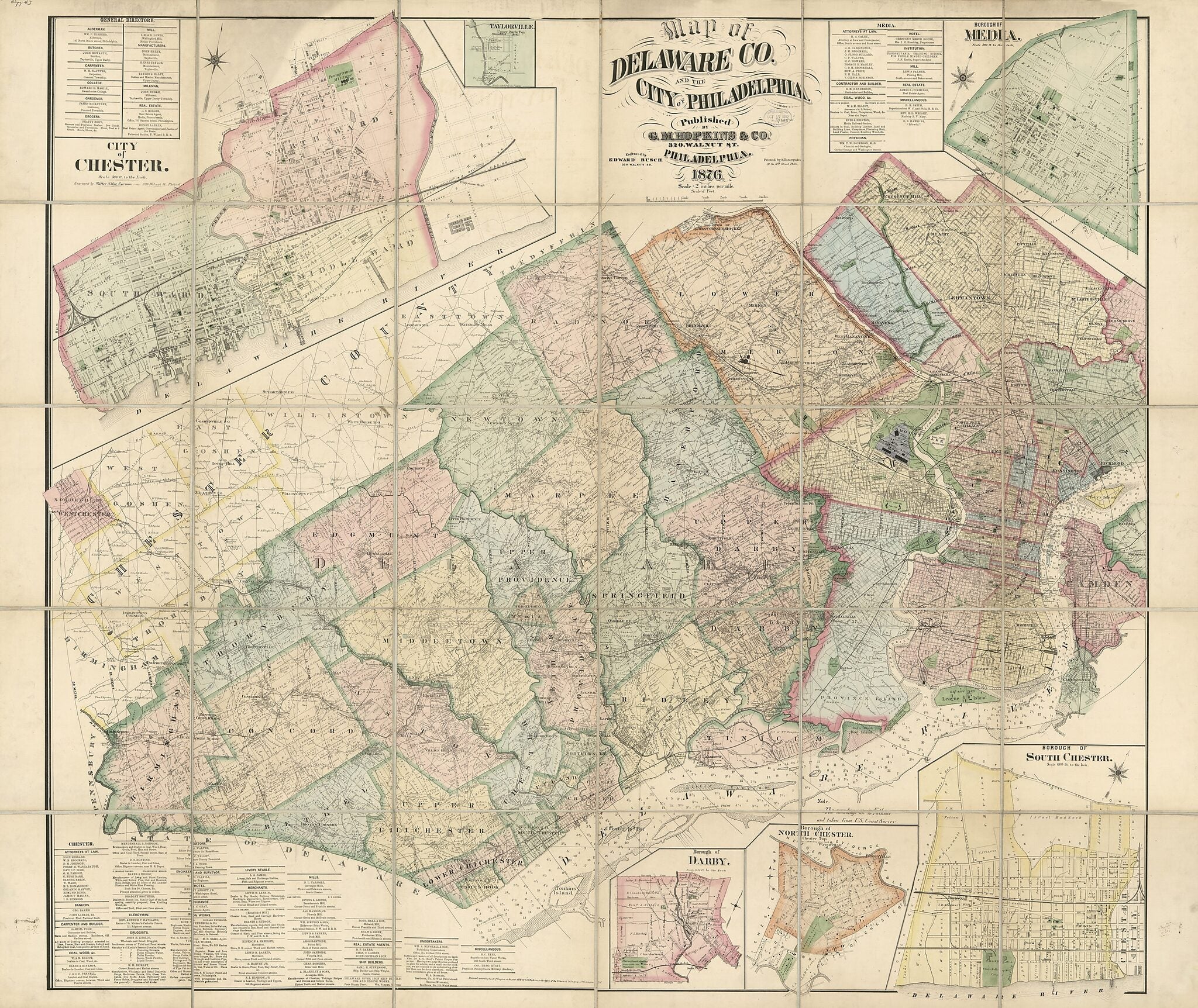
Old cadastral map of Chester, Darby, Delaware County, Drexel Hill, Media, Pennsylvania, Philadelphia, United States.Created by F. (Frederick) Bourquin, Edward Busch, G.M. Hopkins & Co, Griffith Morgan Hopkins in 1876.
- Shows real-property tracts and landowners' names in rural areas of the county and in the Province Island district of Philadelphia.
- Radial distances shown from Philadelphia City Hall.
- Depths shown by soundings.
- Hand col. to distinguish minor civil divisions (townships, boroughs, cities) and numbered wards in Philadelphia.
- Also shows grounds of "International Exposition" in Fairmount Park, Philadelphia.
- "Entered according to act of Congress in the year 1876 by G.M. Hopkins in the Office of the Librarian of Congress at Washington D.C."
- Includes notes and business directories.
- Street-map insets: Borough of Media -- Borough of South Chester [now part of Chester city] -- Borough of North Chester, Chester Twp. [now part of Chester city] -- Borough of Darby -- City of Chester -- Taylorville, Upper Darby Twp. [now part of Drexel Hill].
- Land Ownership Map
- 3 copies
Map Subjects
Administrative And Political Divisions
Cadastral Maps
Chester
Chester (Pa.)
Darby
Darby (Pa.)
Delaware County
Delaware County (Pa.)
Drexel Hill
Drexel Hill (Pa.)
Landowners
Media
Media (Pa.)
Pennsylvania
Philadelphia
Philadelphia (Pa.)
Real Property
United States
Cadastral Maps
F. (Frederick) Bourquin
Edward Busch
G.M. Hopkins & Co
Griffith Morgan Hopkins
1876
- For the best legibility, order your map in the original size or larger. Most maps have intricate detail and small text that is best appreciated when the print size hasn't been reduced.
- Sizes labeled "Fits a Standard Frame" will drop right into any frame that you purchase in that size. The sizes that we offer are commonly available online and at most retail stores.
- Our standard sizes are recommendations based on the aspect ratio of the original map, but still may require some added "white space" in one dimension to fit.
- Non-standard sizes will require custom framing, and we suggest taking your print to the frame shop of your choice after you receive it for the best results.
- Custom sizes are available, simply contact us for a quote.
Below is an approximation of the scale of a few standard sizes, and how they might appear in your space.

