
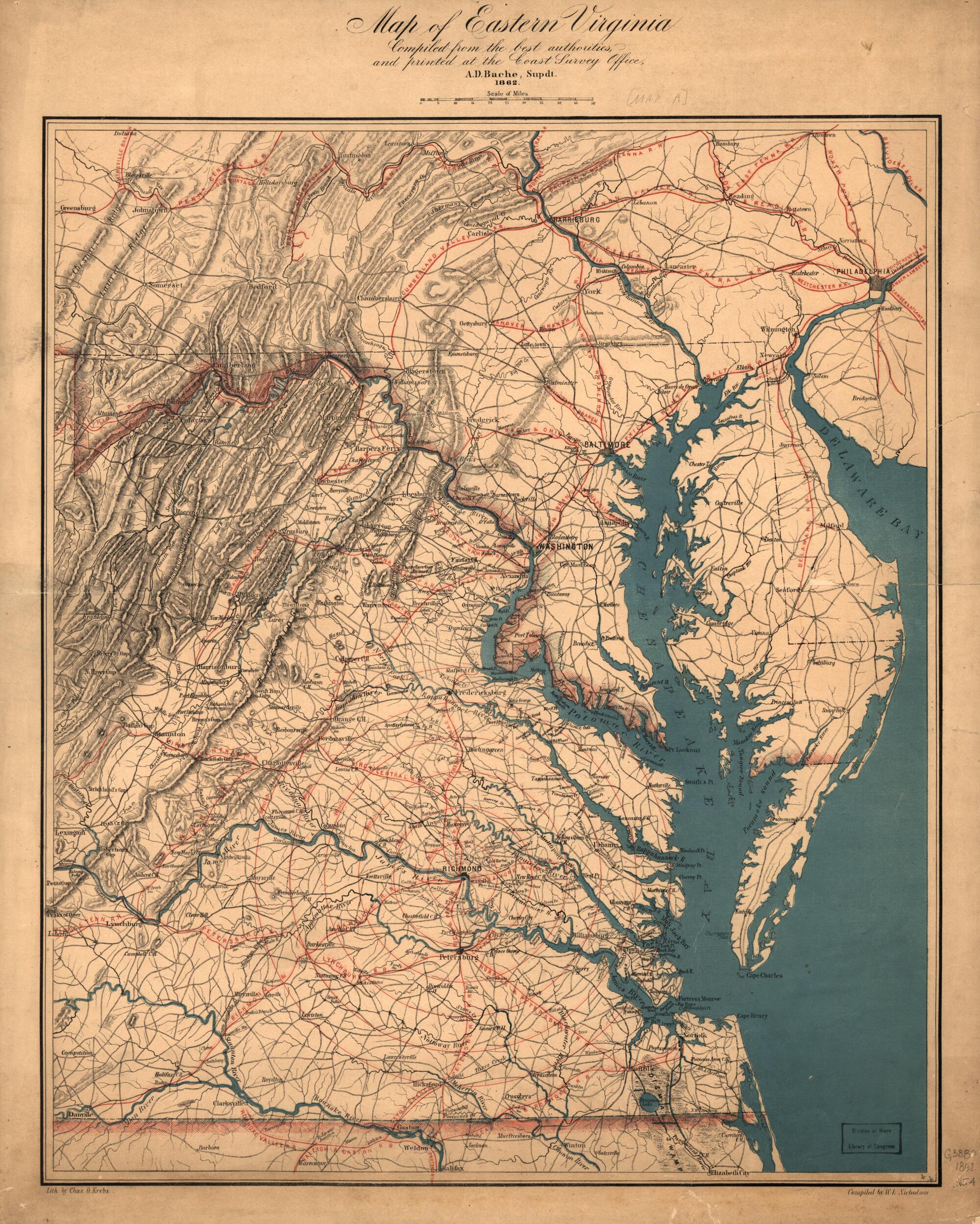
Map of Eastern Virginia 1862
- Regular price
-
$60.95 - Regular price
-
$55.95 - Sale price
-
$60.95
Buy one map, get any other map in our collection for 50% OFF! Add to cart to see discount.
Couldn't load pickup availability
About This Map
Discover the timeless beauty of our fine art quality printed reproduction of this antique map. Perfect for history enthusiasts, collectors, and interior decorators.
Restored with meticulous attention to detail by our team with over a decade of experience, this stunning reproduction captures the intricate artistry and historical significance of the original map.
Whether you're a collector or seeking a unique decor piece, this archival-quality map reproduction is a timeless addition to any space. Order now to bring history to life!
Old map of United States, Virginia.Created by W. L. Nicholson in 1862.
- Scale ca. 1:887,040.
- Civil War Map
- General map of eastern Virginia showing cities and towns, roads, rivers, and relief by hachures. The map is overprinted in red to indicate railroads and concentric circles centered on Richmond. Circles are at intervals of ten miles.
- In his report to the Superintendent of the Coast survey dated November 1, 1862, Nicholson notes that "In addition to the printing of our charts proper, a map representing the seat of war in Virginia was, at the suggestion of the Superintendent, compiled by myself during the past year, and printed in colors, partly as an experiment in that class of work, and partly to meet the popular demand for information on the movements of our armies. This map has met with unexpected success, and has been much called for, and copies quite freely distributed; but, in order to cover the expenses of its getting up and printing, a number of copies have been placed in the hands of our sale agents, the proceeds of which have more than covered expenses; in all, some five thousand five hundred copies have been printed, over twenty-five hundred sold, and nearly three thousand copies gratuitously distributed." (Report of the Superintendent of the Coast Survey, showing the Progress of the Survey during the Year 1862 (Washington: Government Printing Office, 1864). p. 151.)
- This is the first of seven issues in the Library of Congress published in 1862. Distinguishing characteristics include the depiction of the "Blairsville Branch" railroad, the "Manassas Gap R. R." extending to Harrisonburg, Virginia, and the "Delaware R.R." on the Eastern Shore extending to Seaford.
- Description derived from published bibliography.
- For the best legibility, order your map in the original size or larger. Most maps have intricate detail and small text that is best appreciated when the print size hasn't been reduced.
- Sizes labeled "Fits a Standard Frame" will drop right into any frame that you purchase in that size. The sizes that we offer are commonly available online and at most retail stores.
- Our standard sizes are recommendations based on the aspect ratio of the original map, but still may require some added "white space" in one dimension to fit.
- Non-standard sizes will require custom framing, and we suggest taking your print to the frame shop of your choice after you receive it for the best results.
- Custom sizes are available, simply contact us for a quote.
Below is an approximation of the scale of a few standard sizes, and how they might appear in your space.

