
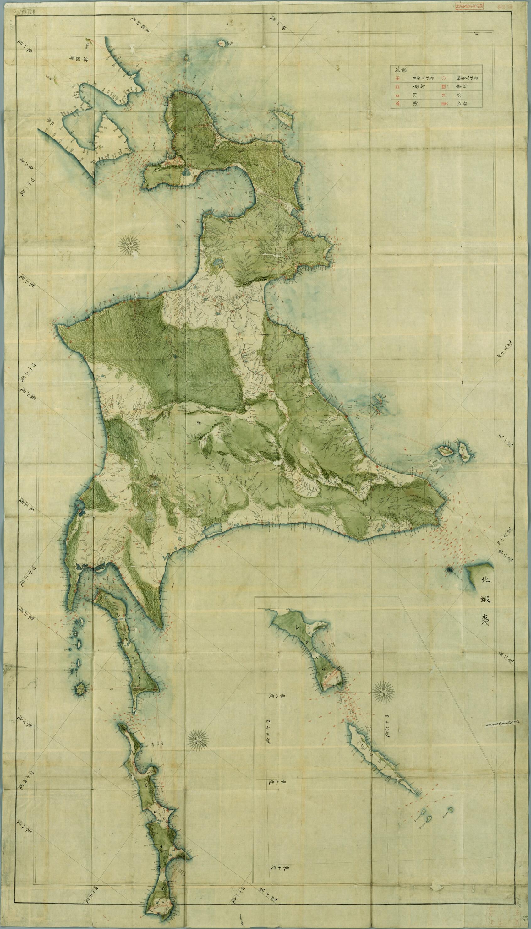
Map of Ezo 1826
- Regular price
-
$207.95 - Regular price
-
$202.95 - Sale price
-
$207.95
Buy one map, get any other map in our collection for 50% OFF! Add to cart to see discount.
Couldn't load pickup availability
About This Map
Discover the timeless beauty of our fine art quality printed reproduction of this antique map. Perfect for history enthusiasts, collectors, and interior decorators.
Restored with meticulous attention to detail by our team with over a decade of experience, this stunning reproduction captures the intricate artistry and historical significance of the original map.
Whether you're a collector or seeking a unique decor piece, this archival-quality map reproduction is a timeless addition to any space. Order now to bring history to life!
Old map of Hokkaido, Japan.-1867) Japan prohibited foreign travel by Japanese people and trade and traffic with other countries, apart from Korea, China, and Holland. In 1828, Philipp Franz Balthasar von Siebold, a German who had come to Japan to work as a doctor at the Dutch trading post, tried to take some prohibited items, including maps of Japan, back to Holland when he completed his posting. Siebold was deported and barred from returning to Japan, while Takahashi Kageyasu (1785-1829, popularly known as Sakuzaemon), the Japanese official from the Astronomy Bureau of the Shogunate who had given Siebold the maps, was executed. All in all, 50 more people were punished for the incident. This map of Ezo (present-day Hokkaido, also seen as Yezo) is believed to be the original of the map that Takahashi gave Siebold. It is almost identical to "Die Insel Jezo und die Japanischen Kurilen, nach einer Originalkarte von Takahasi Sakusaimon, Hofastronomen zu Jedo" (Ezoshima and the Japanese Kuril Islands, based on an original map by Takahashi Sakuzaemon, court astronomer at Edo), which was published as an accompanying map in Nippon, a seven-volume work about Japan by Siebold. There is also a label, believed to date from the investigation of the incident, bearing an inscription asserting that the map (that Takahashi gave Siebold) was an exact copy of this one. The map is affixed with an ownership stamp of the Shōheizaka Academy, which was the educational institution of the Edo Shogunate.
Created by Kageyasu Takahashi in 1826.
- Title devised, in English, by Library staff.
- Original resource extent: 1 sheet ; 112 x 196 centimeters.
- Original resource at: National Diet Library.
- Content in Japanese.
- Description based on data extracted from World Digital Library, which may be extracted from partner institutions.
- For the best legibility, order your map in the original size or larger. Most maps have intricate detail and small text that is best appreciated when the print size hasn't been reduced.
- Sizes labeled "Fits a Standard Frame" will drop right into any frame that you purchase in that size. The sizes that we offer are commonly available online and at most retail stores.
- Our standard sizes are recommendations based on the aspect ratio of the original map, but still may require some added "white space" in one dimension to fit.
- Non-standard sizes will require custom framing, and we suggest taking your print to the frame shop of your choice after you receive it for the best results.
- Custom sizes are available, simply contact us for a quote.
Below is an approximation of the scale of a few standard sizes, and how they might appear in your space.

