
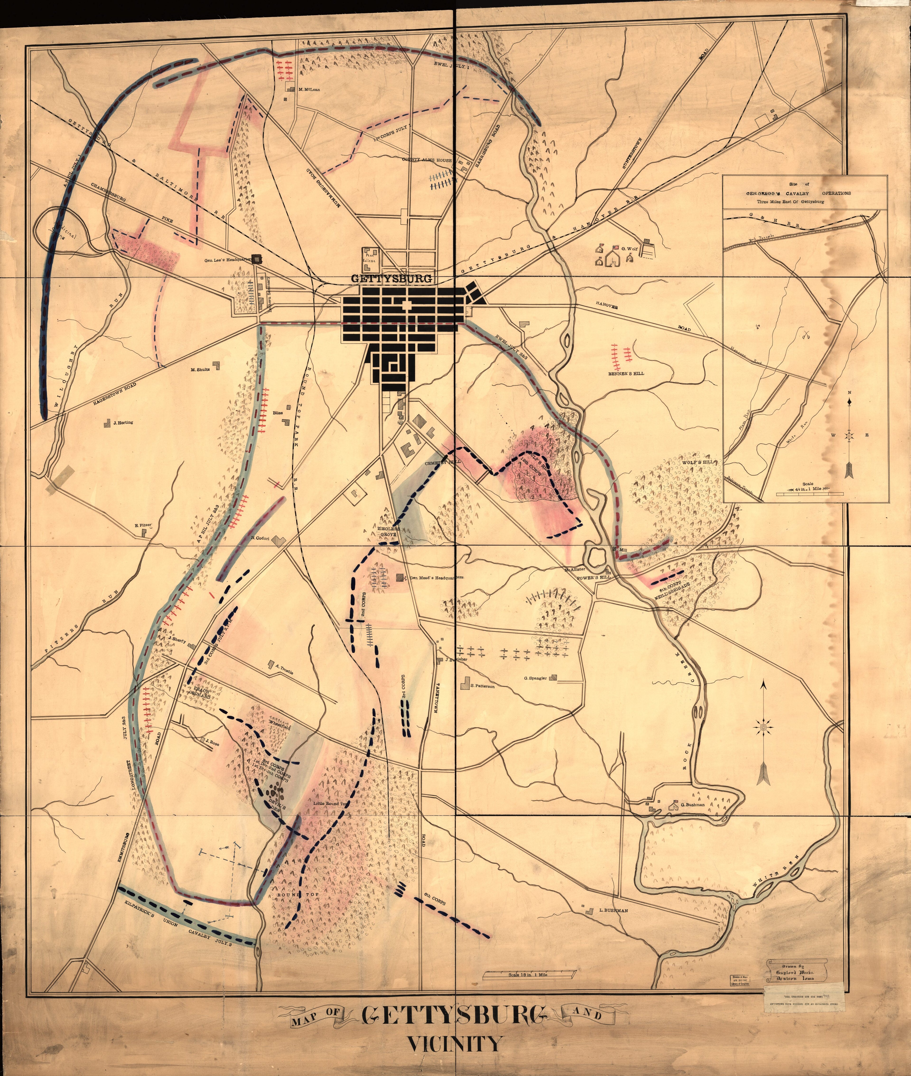
Map of Gettysburg and Vicinity in 1863
- Regular price
-
$200.95 - Regular price
-
$195.95 - Sale price
-
$200.95
Buy one map, get any other map in our collection for 50% OFF! Add to cart to see discount.
Couldn't load pickup availability
About This Map
Discover the timeless beauty of our fine art quality printed reproduction of this antique map. Perfect for history enthusiasts, collectors, and interior decorators.
Restored with meticulous attention to detail by our team with over a decade of experience, this stunning reproduction captures the intricate artistry and historical significance of the original map.
Whether you're a collector or seeking a unique decor piece, this archival-quality map reproduction is a timeless addition to any space. Order now to bring history to life!
Old map of Gettysburg Region, Pennsylvania, United States.Created by Gaylord Weeks in 1863.
- Shows Civil-War battle positions in rural districts surrounding Gettysburg (Pa.). Union lines are shown by blue dashes and Confederate lines by red ones. Also shows locations of artillery, significant features of the battlefield, some dwellings with names of residents, vegetation, drainage, roads, and railways.
- Pen-and-ink, watercolors, and rubber-stamped names.
- Typewritten label affixed at lower right corner reads: Under direction of Mrs. Georgia Wade McClellan 1898 for her personal use.
- Rubber-stamped on cloth backing: Exch., Iowa State Dept. of History & Archives, 4/10/42.
- This map has some imperfections: water-stained along right side. We'll do our best to restore the image before printing.
- Includes inset: Site of Gen. Gregg's cavalry operations, three miles east of Gettysburg. Scale 4 1/2 in. = 1 mile.
- Civil War Map
- For the best legibility, order your map in the original size or larger. Most maps have intricate detail and small text that is best appreciated when the print size hasn't been reduced.
- Sizes labeled "Fits a Standard Frame" will drop right into any frame that you purchase in that size. The sizes that we offer are commonly available online and at most retail stores.
- Our standard sizes are recommendations based on the aspect ratio of the original map, but still may require some added "white space" in one dimension to fit.
- Non-standard sizes will require custom framing, and we suggest taking your print to the frame shop of your choice after you receive it for the best results.
- Custom sizes are available, simply contact us for a quote.
Below is an approximation of the scale of a few standard sizes, and how they might appear in your space.

