
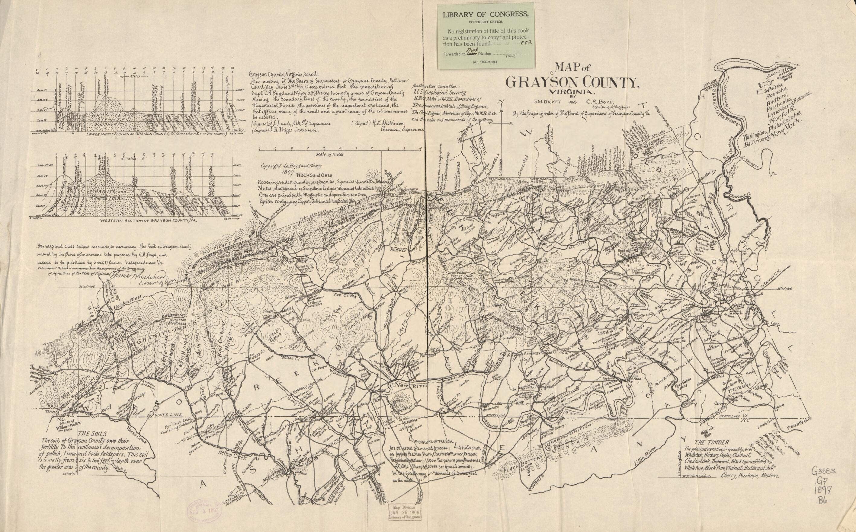
Map of Grayson County, Virginia 1897
- Regular price
-
$52.95 - Regular price
-
$47.95 - Sale price
-
$52.95
Buy one map, get any other map in our collection for 50% OFF! Add to cart to see discount.
Couldn't load pickup availability
About This Map
Discover the timeless beauty of our fine art quality printed reproduction of this antique map. Perfect for history enthusiasts, collectors, and interior decorators.
Restored with meticulous attention to detail by our team with over a decade of experience, this stunning reproduction captures the intricate artistry and historical significance of the original map.
Whether you're a collector or seeking a unique decor piece, this archival-quality map reproduction is a timeless addition to any space. Order now to bring history to life!
Old cadastral map of Grayson County, United States, Virginia.Created by Charles Rufus Boyd, Samuel Dickey in 1897.
- Relief shown by hachures.
- Shows economic and geologic cross section information and the names of some residents.
- "Authorities consulted: U.S. Geological Survey, H.B.C. Nitze in vol XXI, Transactions of the American Institute of Mining Engineers, The Chief Engineer, maintenance of way, N & W. RR Co., and the notes and memoranda of the authors."
- "This map and cross sections are made to accompany the book on Grayson County ordered by the Board of Supervisors to be prepared by C.R. Boyd and ordered to be published by Greek D. Brown, Independence, Va."
- Land Ownership Map
- Includes text and geologic cross sections: Lower middle section of Grayson County, Va. (Eastern half of the county) and Western Section of Grayson County, Va.
- Copy This map has some imperfections: torn in half along vertical fold. green sticky note from library of congress copyright office attached to recto. We'll do our best to restore the image before printing.
- For the best legibility, order your map in the original size or larger. Most maps have intricate detail and small text that is best appreciated when the print size hasn't been reduced.
- Sizes labeled "Fits a Standard Frame" will drop right into any frame that you purchase in that size. The sizes that we offer are commonly available online and at most retail stores.
- Our standard sizes are recommendations based on the aspect ratio of the original map, but still may require some added "white space" in one dimension to fit.
- Non-standard sizes will require custom framing, and we suggest taking your print to the frame shop of your choice after you receive it for the best results.
- Custom sizes are available, simply contact us for a quote.
Below is an approximation of the scale of a few standard sizes, and how they might appear in your space.
