
Map of Lehigh County, Pennsylvania : from Original Surveys 1862
- Regular price
-
$206.95 - Regular price
-
$201.95 - Sale price
-
$206.95
Buy one map, get any other map in our collection for 50% OFF! Add to cart to see discount.
Couldn't load pickup availability
About This Map
Discover the timeless beauty of our fine art quality printed reproduction of this antique map. Perfect for history enthusiasts, collectors, and interior decorators.
Restored with meticulous attention to detail by our team with over a decade of experience, this stunning reproduction captures the intricate artistry and historical significance of the original map.
Whether you're a collector or seeking a unique decor piece, this archival-quality map reproduction is a timeless addition to any space. Order now to bring history to life!
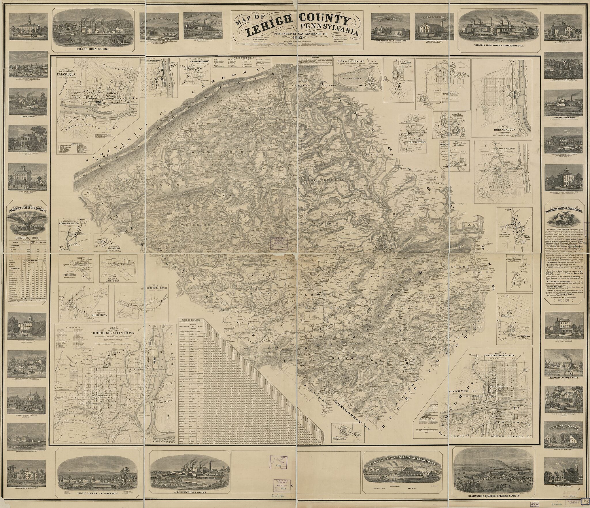
Old cadastral map of Allentown, Bethlehem, Catasauqua, Hokendauqua, Lehigh County, Pennsylvania, Slatington, United States.Created by G. A. Aschbach, M. H. (Morris H.) Traubel in 1862.
- General-content county map also showing buildings in rural areas and householders' names; some insets also show relief with contours, real-property tracts, landowners' names, and building coverage.
- Relief shown by hachures and spot heights.
- Differs from other 1862 ed. in not having a low-angle view of Allentown at the bottom margin.
- "Entered according to Act of Congress by G.A. Aschenbach in the year 1962 in ... the eastern District of Pennsylvania."
- This map has some imperfections: copy 1 rubber-stamped, annotated in black ink/blue pencil/lead pencil; copy 2 missing small edge sections, rubber-stamped, annotated in blue pencil, adhesive labels affixed. We'll do our best to restore the image before printing.
- Includes text (historical), notes, table of road distances, statistical table (1860 census), and ill. of industrial plants, business enterprises, and selected residences.
- Borough and village insets (titles abbreviated): Borough of Allentown -- Millerstown -- Emaus [sic] -- Fogelsville -- New Texas -- Steinsville -- Germansville P.O. -- Borough of Catasauqua -- Lehigh Valley Iron Works and Copley Station -- Saegersville -- Guthsville -- Schnecksville P.O. -- Ironton & vicinity -- Trexlertown -- Orefield and the Orefield mines -- Slatedale P.O. late Labarsville -- Hokendauqua -- Slatington and the adjacent slate quarries -- Siegersville P.O. -- Coopersburg -- Friedensville and the zinc mines -- Bethlehem and vicinity -- Centre Valley.
- 2 copies
Map Subjects
Allentown
Allentown (Pa.)
Bethlehem
Bethlehem (Pa.)
Cadastral Maps
Catasauqua
Catasauqua (Pa.)
Cities And Towns
Hokendauqua
Hokendauqua (Pa.)
Landowners
Lehigh County
Lehigh County (Pa.)
Pennsylvania
Real Property
Slatington
Slatington (Pa.)
United States
Villages
G. A. Aschbach
M. H. (Morris H.) Traubel
1862
- For the best legibility, order your map in the original size or larger. Most maps have intricate detail and small text that is best appreciated when the print size hasn't been reduced.
- Sizes labeled "Fits a Standard Frame" will drop right into any frame that you purchase in that size. The sizes that we offer are commonly available online and at most retail stores.
- Our standard sizes are recommendations based on the aspect ratio of the original map, but still may require some added "white space" in one dimension to fit.
- Non-standard sizes will require custom framing, and we suggest taking your print to the frame shop of your choice after you receive it for the best results.
- Custom sizes are available, simply contact us for a quote.
Below is an approximation of the scale of a few standard sizes, and how they might appear in your space.

