
Panama (Map of Proposed Railroad Line, Panama) 1838
- Regular price
-
$54.95 - Regular price
-
$38.95 - Sale price
-
$54.95
Shipping calculated at checkout.
Buy one map, get any other map in our collection for 50% OFF! Add to cart to see discount.
Couldn't load pickup availability
About This Map
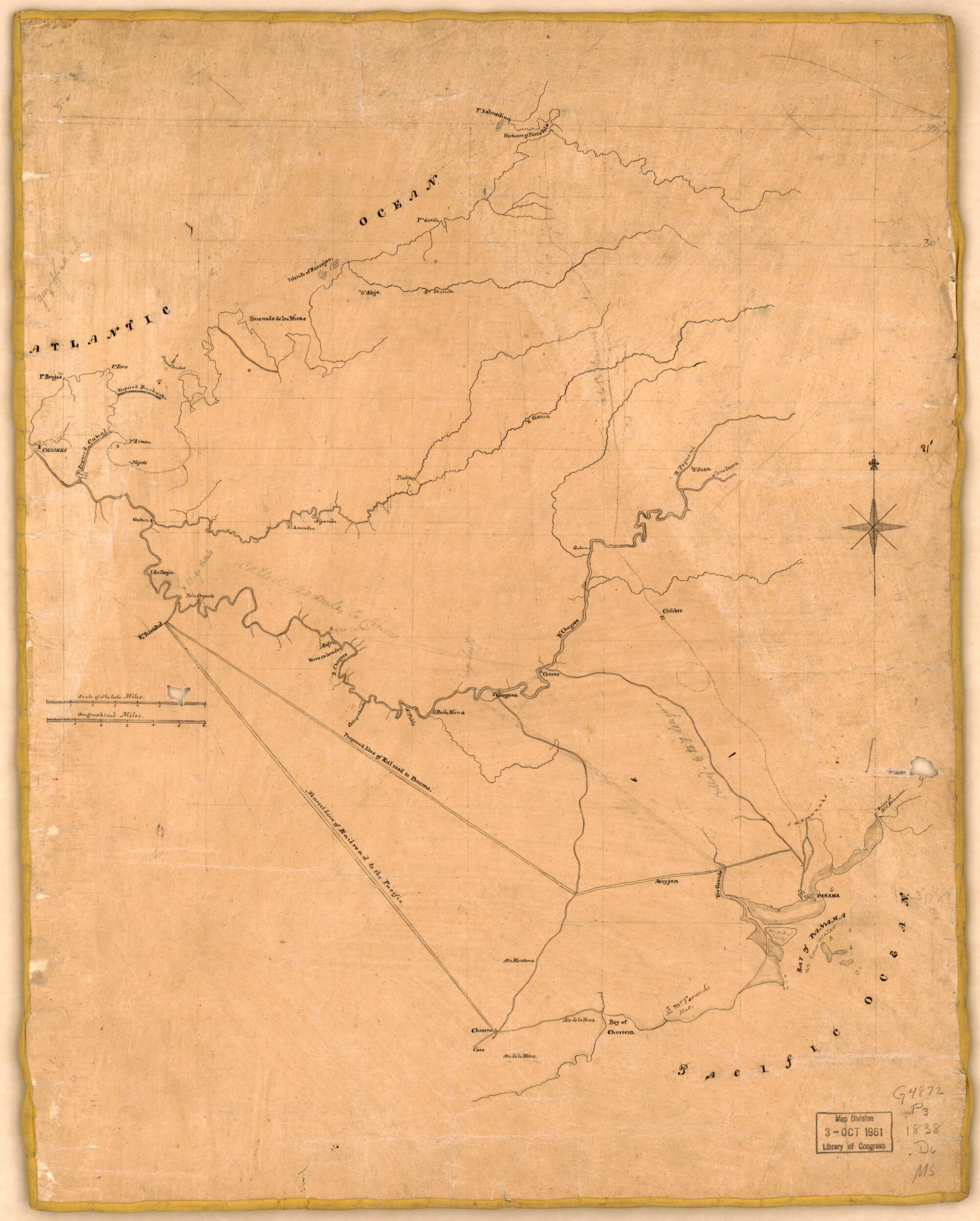
Old manuscript map of Isthmus of, Panama, Panama, Isthmus of (Panama).
Created by David Bates Douglass in 1838.
Created by David Bates Douglass in 1838.
- Covers the Isthmus of Panama from Panama City and Chorera on the Pacific Coast to Chagres and Portobelo Harbor on the Caribbean Coast.
- Also shows rivers, streams, settlements, an existing rail line, a proposed rail line to Panama City, a proposed canal, roads, a trail, coastline, coastal features, and anchorages.
- Title written in ink from verso.
- Pencil, pen-and-ink and wash.
- On verso at top in script and black ink: To: J.B. Feraud, esq.
- On verso in ink in bottom right corner: No.17 Coll. of Major DB Douglass, abt. 1838.
- This map has some imperfections: crack-lined, darkened, water-stained, holes throughout with minor losses, gold stitched along edges, and mounted on cloth. We'll do our best to restore the image before printing.
Map Sizing Information
- For the best legibility, order your map in the original size or larger. Most maps have intricate detail and small text that is best appreciated when the print size hasn't been reduced.
- Sizes labeled "Fits a Standard Frame" will drop right into any frame that you purchase in that size. The sizes that we offer are commonly available online and at most retail stores.
- Our standard sizes are recommendations based on the aspect ratio of the original map, but still may require some added "white space" in one dimension to fit.
- Non-standard sizes will require custom framing, and we suggest taking your print to the frame shop of your choice after you receive it for the best results.
- Custom sizes are available, simply contact us for a quote.
Below is an approximation of the scale of a few standard sizes, and how they might appear in your space.

