
Map of Russian America Or Alaska Territory. Compiled from Russian Charts and Surveys by J. F. Lewis 1867
- Regular price
-
$98.95 - Regular price
-
$93.95 - Sale price
-
$98.95
Buy one map, get any other map in our collection for 50% OFF! Add to cart to see discount.
Couldn't load pickup availability
About This Map
Discover the timeless beauty of our fine art quality printed reproduction of this antique map. Perfect for history enthusiasts, collectors, and interior decorators.
Restored with meticulous attention to detail by our team with over a decade of experience, this stunning reproduction captures the intricate artistry and historical significance of the original map.
Whether you're a collector or seeking a unique decor piece, this archival-quality map reproduction is a timeless addition to any space. Order now to bring history to life!
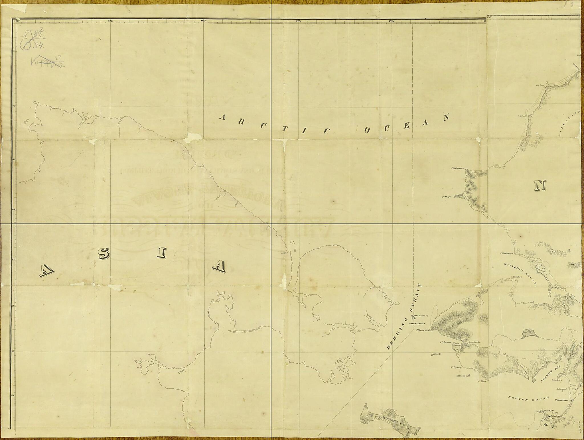
Old map of Alaska, United States.part American map, preserved in the collections of the Russian State Library in Moscow, was produced in 1867 at the time of the Alaska Purchase, when the United States acquired Russia's colonial possessions in North America. The map was mostly compiled from charts and surveys utilized by the Western Union Telegraph Company in its effort to build a telegraph line from North America to Asia across the Bering Strait. Few other Americans had such detailed knowledge of Alaskan geography at that time as the members of this famous endeavor. From 1865-67, the Western Union Telegraph Expedition (or Russian-American Telegraph) worked on a project to lay a telegraph line through Alaska and Siberia that ultimately would link San Francisco to Moscow and there connect to existing lines from Russia to Western Europe. This approach was seen at the time as an alternative to the transatlantic cable from the east coast of North America to Europe, the viability of which had not yet been established. Colonel Charles Bulkley was the chief engineer of the Western Union effort. J.F. Lewis was the chief draughtsman for this map. Place-names on the map are written in English, even though the original sources were often Russian. The four sections of the map show different parts of Alaska and the Aleutian Islands as well as a part of Chukotka on the Russian mainland. The Alaska-Canada border in the second and fourth sections is highlighted prominently in light blue. The fourth section also contains five insets at the bottom, for the Alaskan settlements at Captain Harbor (Unalaska Island), Coal Harbor (Unga Island), Saint Paul Harbor (Kodiak Island), Port Mulgrave (Yakutat Bay), and Sitka Harbor (Novo-Arkhangelsk). The scale for the insets is in nautical miles (one nautical mile = 1.85 kilometers); soundings are given in fathoms. Relief throughout is shown by hachures and shading. World Digital Library.
Created by Charles S. Bulkley, J. F. Lewis, Western Union Telegraph Company in 1867.
- Setka geograficheskikh koordinat. Dolgota ot Grinvicha.
- Rel'ef shtrikhovkoĭ. Naneseny gosudarstvennye granit︠s︡y. Pokazany forty, bol'shie i malye naselennye punkty.
- Original map at: Russian State Library
- Сетка географических координат. Долгота от Гринвича.
- Рельеф штриховкой. Нанесены государственные границы. Показаны форты, большие и малые населенные пункты.
Map Subjects
Alaska
Colonies
Russia
United States Of America
Western Union Telegraph Expedition
United States
Charles S. Bulkley
J. F. Lewis
Western Union Telegraph Company
1867
- For the best legibility, order your map in the original size or larger. Most maps have intricate detail and small text that is best appreciated when the print size hasn't been reduced.
- Sizes labeled "Fits a Standard Frame" will drop right into any frame that you purchase in that size. The sizes that we offer are commonly available online and at most retail stores.
- Our standard sizes are recommendations based on the aspect ratio of the original map, but still may require some added "white space" in one dimension to fit.
- Non-standard sizes will require custom framing, and we suggest taking your print to the frame shop of your choice after you receive it for the best results.
- Custom sizes are available, simply contact us for a quote.
Below is an approximation of the scale of a few standard sizes, and how they might appear in your space.

