
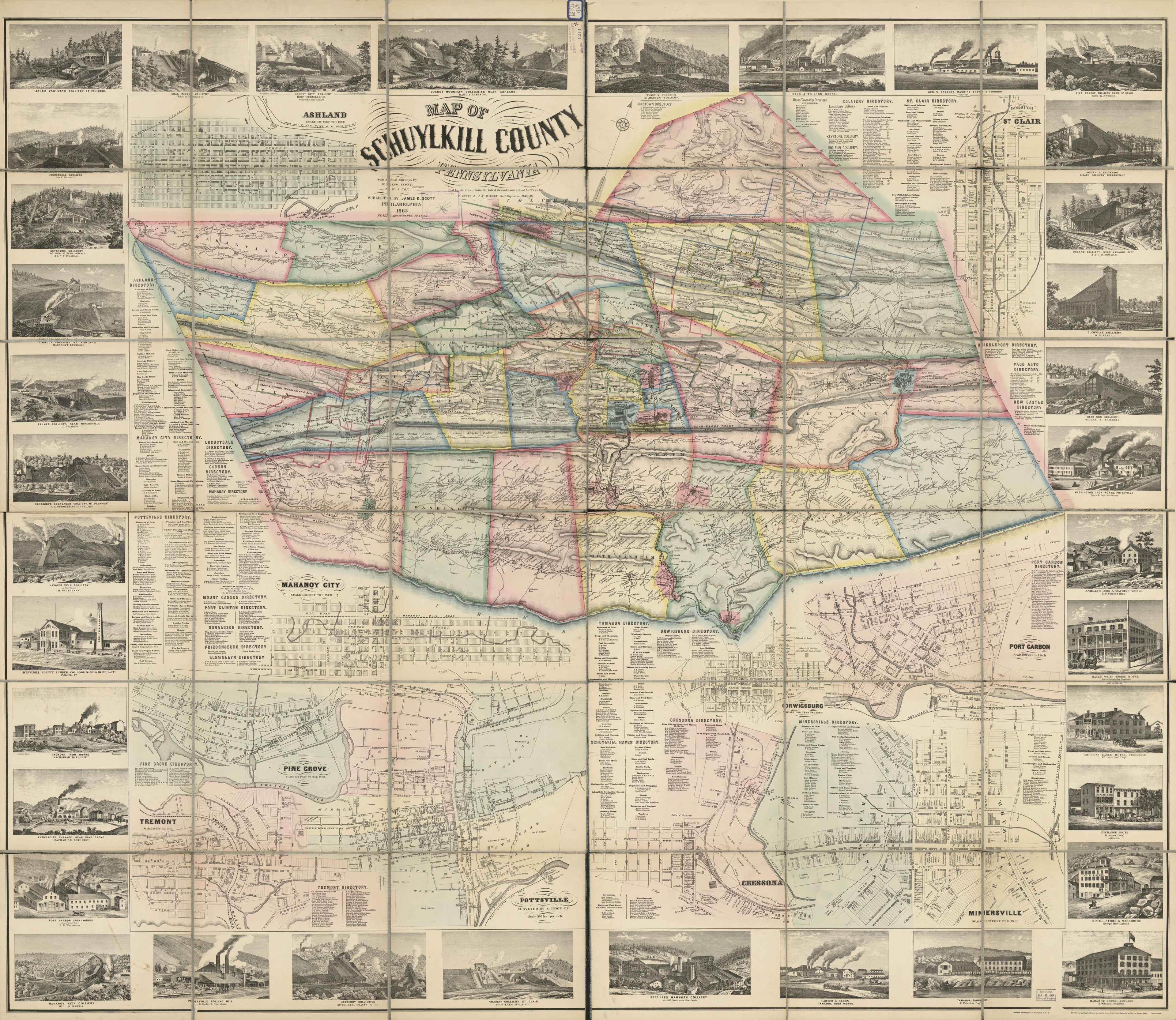
Map of Schuylkill County, Pennsylvania : From Actual Surveys in 1863
- Regular price
-
$204.95 - Regular price
-
$199.95 - Sale price
-
$204.95
Buy one map, get any other map in our collection for 50% OFF! Add to cart to see discount.
Couldn't load pickup availability
About This Map
Discover the timeless beauty of our fine art quality printed reproduction of this antique map. Perfect for history enthusiasts, collectors, and interior decorators.
Restored with meticulous attention to detail by our team with over a decade of experience, this stunning reproduction captures the intricate artistry and historical significance of the original map.
Whether you're a collector or seeking a unique decor piece, this archival-quality map reproduction is a timeless addition to any space. Order now to bring history to life!
Old cadastral map of Ashland, Cressona, Mahanoy City, Minersville, Orwigsburg, Pennsylvania, Pine Grove, Pine Grove (Schuylkill County), Port Carbon, Pottsville, Saint Clair, Schuylkill County, St. Clair (Schuylkill County), Tremont, United States.Created by W. J. Cox, S. Lewis & J.S. Hawley Civil Engineers, James D. Scott, Walter Scott in 1863.
- Shows householders' names in rural areas, real-property tracts in mining townships, coal mining lands, colliery locations, and anthracite coal seams in gray tint; also shows lot lines, buildings, and owners' names in the borough insets.
- Relief shown by hachures.
- Hand col. to distinguish townships, boroughs, anthracite-mining company lands, and railroad company lands.
- "Entered according to Act of Congress in the year [words not printed] Scott in ... and for the Eastern District of Pennsylvania."
- Sectioned to 36 panels to enable folding.
- Land Ownership Map
- Includes borough business directories and ill. of collieries/industries/hotels.
- Borough insets: Ashland -- St. Clair -- Port Carbon -- Orwigsburg -- Minersville -- Cressona -- Pottsville -- Pine Grove -- Tremont -- Mahanoy City.
- For the best legibility, order your map in the original size or larger. Most maps have intricate detail and small text that is best appreciated when the print size hasn't been reduced.
- Sizes labeled "Fits a Standard Frame" will drop right into any frame that you purchase in that size. The sizes that we offer are commonly available online and at most retail stores.
- Our standard sizes are recommendations based on the aspect ratio of the original map, but still may require some added "white space" in one dimension to fit.
- Non-standard sizes will require custom framing, and we suggest taking your print to the frame shop of your choice after you receive it for the best results.
- Custom sizes are available, simply contact us for a quote.
Below is an approximation of the scale of a few standard sizes, and how they might appear in your space.

