


1
/
of
1
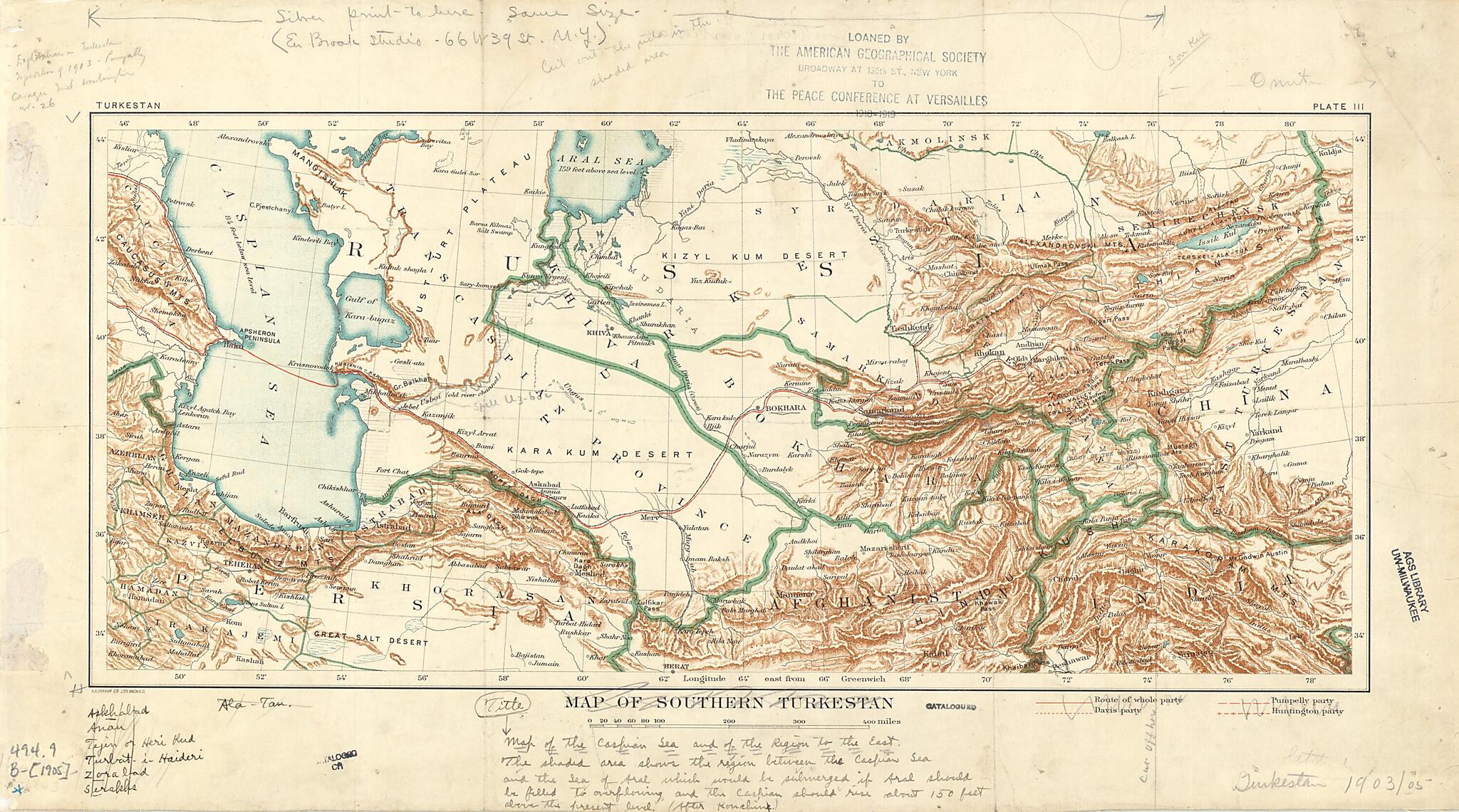
Map of Southern Turkestan 1905
- Regular price
-
$27.95 - Regular price
-
$42.95 - Sale price
-
$27.95
Couldn't load pickup availability
90-Day Satisfaction Guarantee & Free Returns
About This Map
Discover the timeless beauty of our fine art quality printed reproduction of this antique map. Perfect for history enthusiasts, collectors, and interior decorators.
Restored with meticulous attention to detail by our team with over a decade of experience, this stunning reproduction captures the intricate artistry and historical significance of the original map.
Whether you're a collector or seeking a unique decor piece, this archival-quality map reproduction is a timeless addition to any space. Order now to bring history to life!
Old map of Kazakhstan, Russian Federation, Tajikistan, Turkmenistan, Uzbekistan.Generalship of Turkestan. Of note on this map are the Emirate of Bokhara and the Khanate of Khiva, which were not included in the governor-generalship. Both were made Russian protectorates, following their defeats at the hand of Russia. The Khanate of Kokand (corresponding roughly to the area marked as Ferghana) was conquered in 1876 and, rather than being afforded protectorate status, was annexed into the vast domains of the Governor-Generalship of Turkestan. Today the portion of this map that corresponds to Central Asia falls within the borders of the states of Turkmenistan, Tajikistan, Kazakhstan, Uzbekistan, and Kyrgyzstan, all former Soviet republics that gained independence following the dissolution of the Soviet Union in 1991. A handwritten note describes the consequences of the rising of the Aral and Caspian Seas, a process that would be dramatically reversed in the latter part of the 20th century, when the Aral Sea all but disappeared as a consequence of ill-conceived Soviet irrigation projects. The map is marked "Loaned by the American Geographical Society to the Peace Conference at Versailles, 1918-1919."
Created by Carnegie Institution of Washington, United States. Department of State in 1905.
- Title devised, in English, by Library staff.
- "Scale about 1:5,645,600"--Note extracted from World Digital Library.
- Original resource extent: 1 map : annotated, color, mounted on linen ; 21 x 47 centimeters.
- Original resource at: University of Wisconsin-Milwaukee Libraries.
- Content in English.
- Description based on data extracted from World Digital Library, which may be extracted from partner institutions.
Map Subjects
1903 To 1919
Carnegie Institution Of Washington
Davis William Morris
Expeditions And Surveys
Huntington Ellsworth
Kazakhstan
Library Of Congress Afghanistan Project
Pumpelly Raphael
Russian Federation
Tajikistan
Treaty Of Versailles (1919)
Turkmenistan
Uzbekistan
World War
Carnegie Institution Of Washington
United States. Department Of State
1905
Map Tags
1903 To 1919
1905
Carnegie Institution Of Washington
Davis William Morris
Expeditions And Surveys
Huntington Ellsworth
Kazakhstan
Library Of Congress Afghanistan Project
Map
Pumpelly Raphael
Russian Federation
Tajikistan
Treaty Of Versailles (1919)
Turkmenistan
United States. Department Of State
Uzbekistan
World War
Secure Checkout
Lifetime Warranty
Money-Back Guarantee
Map Sizing Information
- For the best legibility, order your map in the original size or larger. Most maps have intricate detail and small text that is best appreciated when the print size hasn't been reduced.
- Sizes labeled "Fits a Standard Frame" will drop right into any frame that you purchase in that size. The sizes that we offer are commonly available online and at most retail stores.
- Our standard sizes are recommendations based on the aspect ratio of the original map, but still may require some added "white space" in one dimension to fit.
- Non-standard sizes will require custom framing, and we suggest taking your print to the frame shop of your choice after you receive it for the best results.
- Custom sizes are available, simply contact us for a quote.
Below is an approximation of the scale of a few standard sizes, and how they might appear in your space.
